Chicago Storm
-
Posts
19,232 -
Joined
-
Last visited
Content Type
Profiles
Blogs
Forums
American Weather
Media Demo
Store
Gallery
Everything posted by Chicago Storm
-
Still looks like a close call for the IL/WI border area, very dependent on dynamic cooling. Much of WI still set to do decently, though.
-
This is right up you alley...
-
tth.
-
While Minnesota/Duluth/Bo-land were always expected to experience something significant, odds have been increasing for more of Wisconsin to have a shot at something meaningful now as well. Another wave rounds the main trough, with secondary development Wed/Thur. Something to watch for the Southern Wisconsin crowd (Maybe even IL/WI border area?). Outside of that, other areas could pick up some snow showers and minor accumulation with wrap around activity on Thur/Fri.
-
-

2022 Short/Medium Range Severe Weather Discussion
Chicago Storm replied to Chicago Storm's topic in Lakes/Ohio Valley
but are we though? -

-
Winter 2022/23 Short/Medium Range Discussion
Chicago Storm replied to Chicago Storm's topic in Lakes/Ohio Valley
but is it though?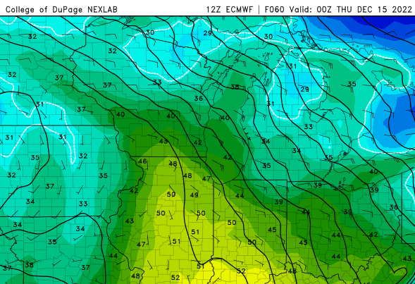
-
but has there really been zero snow?
-
how'd that go?
-
where's cromartie? need an update on the torch incoming heading into the christmas period.
-
Winter 2022/23 Medium/Long Range Discussion
Chicago Storm replied to Chicago Storm's topic in Lakes/Ohio Valley
. -
Winter 2022/23 Medium/Long Range Discussion
Chicago Storm replied to Chicago Storm's topic in Lakes/Ohio Valley
re-read what the post said. . -
Winter 2022/23 Medium/Long Range Discussion
Chicago Storm replied to Chicago Storm's topic in Lakes/Ohio Valley
Running a day or two later than I wanted to get this out, but nonetheless... The middle 1/3rd of December (10-20th) will sort of be a transitional period. The well advertised Plains storm system for next week will be a rainer for many (Backside snow potential?), though there will most definitely be some accumulating snow across MN/WI/MI. That snow potential and the fact that any push of mild temperatures will be very muted/confined to the southern half of the sub-forum, will be thanks to the continued significant -NAO/Greenland block and associated 50/50 low that will be in place across the Northeast/Southeast Canada/adjacent Atlantic. So anyone that was onboard the mild for days or super mild temperatures train, be prepared to be derailed. Beyond the aforementioned storm system for next week, the final half of this middle 1/3rd of December is when see things start to take shape. We will slide into an -EPO/-AO/-NAO/N to -PNA pattern, with a SWE occurring as well (SPV on the move from Siberia to Greenland. This should lead to an overall colder temperature pattern for the closing days of this middle of the month period, but whether it's CAD or cold and active is still TBD. This pattern as of now would then continue into Christmas week. As mentioned in another thread post, this is probably one of the best looking patterns on paper that the GEFS/EPS have shown in years for December. However, after the 180 flip for the pattern in the current period we are in, caution should definitely be taken. We'll see how it goes.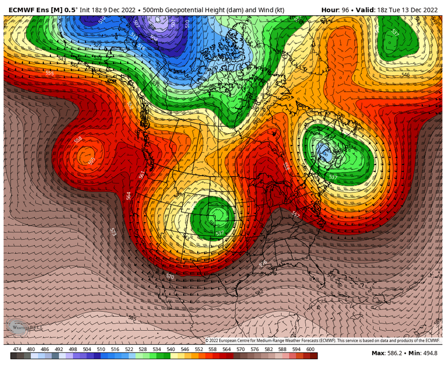
-
Winter 2022/23 Medium/Long Range Discussion
Chicago Storm replied to Chicago Storm's topic in Lakes/Ohio Valley
GEFS/EPS at face value, it's one of the best looking potential Dec patterns in years. But that's at face value, and we know how ENS ended up doing a 180 for the period we are in now. So maybe cautious optimism, but there's a fine line between cold/active and CAD. -
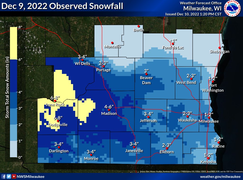
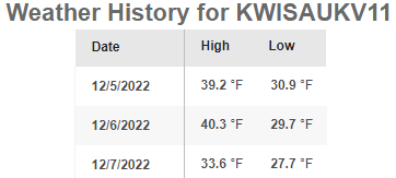
A range of wintry precip at ORD this morning, with SN, GS and PL at some point. Event snowfall total of 0.2” at ORD. Ended up with mostly rain at home, with just a few snow flakes/snow pellets mixed in towards the end.
-
Looks like dynamic cooling was a little less than what most guidance was showing, which was enough to have the snow and rain/snow mix end up about a county or so north of what was expected.
-
KFSD 090256Z COR 09009KT 1/2SM SN FG VV005 01/M01 A3010 RMK AO2 SLP213 SNINCR 4/6 P0019 60050 I3002 T00111011 58013 RVRNO
-
KFSD 090156Z 09007KT 1/2SM SN FG VV008 00/M02 A3011 RMK AO2 SLP219 SNINCR 2/2 P0027 T00001017 RVRNO
-
That's a questionable statement.
-
Winter 2022/23 Medium/Long Range Discussion
Chicago Storm replied to Chicago Storm's topic in Lakes/Ohio Valley
ricky lol'd at your thought that we have had a period of cad at any point so far. -
break out the gold bond and speedo.
-
Winter 2022/23 Medium/Long Range Discussion
Chicago Storm replied to Chicago Storm's topic in Lakes/Ohio Valley
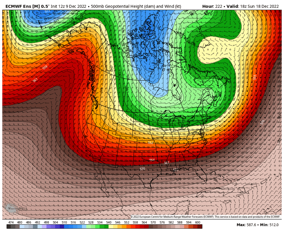
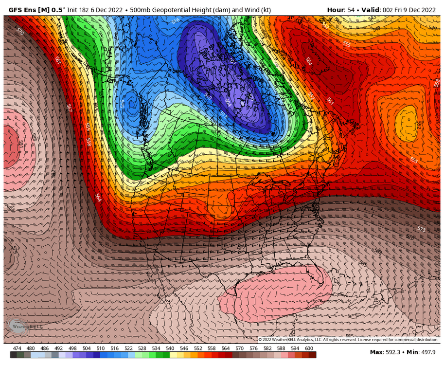
Should add an image comparison of the pattern, from what it looked like previously (Top) to what it is expected to look like now (Bottom).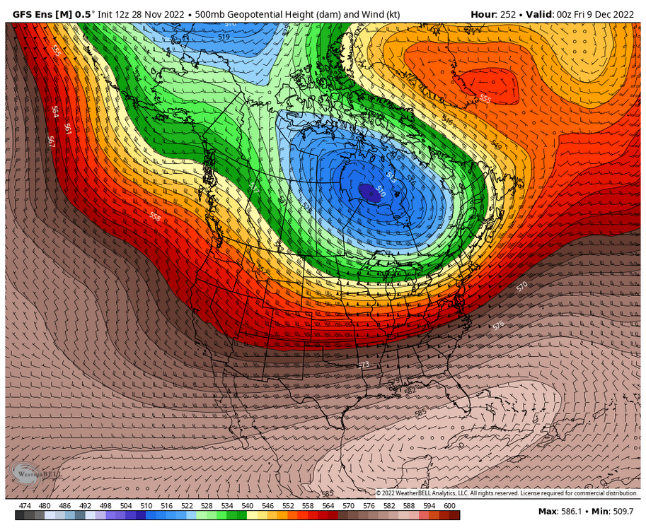
-
Winter 2022/23 Medium/Long Range Discussion
Chicago Storm replied to Chicago Storm's topic in Lakes/Ohio Valley
Portions of this first 1/3rd of the month are going as planned, and other portions are not (Bolded parts of the above quoted previous post are what will not be working out). As has been mentioned in other threads, a big fail point for the upcoming times is going to be medium/long range guidance failing horribly with the handling of things, especially the PV lobe in Canada. This is the first time medium/long range informaton has performed this badly since this past spring. The MJO movement, which has been a big signal for the pattern for far this season, has also not been as helpful in this case. Instead of the Canadian PV lobe parking on the south Hudson coast beneath the NAO block, we are seeing it instead make a brief appearance there, before quickly returning back north to the Arctic. What this means for late in this opening 1/3rd of the month and continuing into the middle 1/3rd of the month, is instead of a pattern featuring more consisently/widespread colder temps and a WNW/NW flow pattern that would likely not be as active or conducive to big storms... We end up with more a mild/cool temp pattern, and a pattern that is more active and supportive of bigger storm systems. Will have more thought on the middle 1/3rd of the month in its entirety soon.

-
Winter 2022/23 Medium/Long Range Discussion
Chicago Storm replied to Chicago Storm's topic in Lakes/Ohio Valley
There was nothing of note for most prior to Christmas last year. There were two threads created (One in early Dec & one in Nov), but both events faded well in advance. Outside of that, not much happened either, other than up north near Duluth/UP-land. Going back two winters ago, to the start of winter 2020/2021... We also only had two thread worthy events prior to Christmas, which did end up producing for areas of MN/WI/MI. So we are already ahead of where we were pretty much the last two winters. So far this season we have had that surprise event about a month ago across MO/IL/IN/KY, and then the lighter event further north up around here a few weeks ago. Minnesota/N WI/N MI have obviously had several events too. Then add in the upcoming Thur/Friday event for somewhere.