

Chicago Storm
-
Posts
19,239 -
Joined
-
Last visited
Content Type
Profiles
Blogs
Forums
American Weather
Media Demo
Store
Gallery
Everything posted by Chicago Storm
-
Storms keep re-developing off of the OFB, and just had 47MPH wind gusts once again with one of said storms.
-
47MPH wind gusts here at ORD with a storm developing overhead on the OFB.
-
97 at ex home, 96 at MDW, and 95 at ORD and RFD today.26 - Ex Home25 - RFD21 - MDW18 - ORD
-
Not a chance.
-
A few tor warned supercells in S WI now, though north of the southward moving OFB.
-
61MPH gusts at Waterloo on the southern edge of the line. Apex further north is probably producing 70MPH+. RIJ showing up well on KDVN.
-
I’ve seen enough to say an ENH is needed on the 20z update in a corridor across NE IA into N IL. .
-
To add to the above, SPC will need to add a slight risk to portions of IA/S WI/N IL with the the 20z SWODY1. If not for potential issues with the lead re-organizing complex in E WI and capping concerns, one could push for an ENH risk for that aforementioned corridor.
-
Fairly complex scenario/evolution of things today... The first two MCS that have been moving across MN/WI early this morning into early this afternoon have sort of merged/organized into one complex, now affecting E WI...and likely eventually pushing into MI as well. Further west, I had mentioned earlier this morning that any local potential would depend on festering activity on the southern edge of the morning MCS's. This activity survived the morning and also has organized into an MCS along the MN/IA border. This MCS has a fairly good environment ahead of it, characterized by a solid instability/moisture/theta-e reservoir, quality shear with multiple waves/MCV's riding the north edge of the ridge, and a nice thermal ridge nosing in. Should see this MCS ride E or ESE, near/along the OFB in place from earlier activity across N IA/S WI.
-
Unless the tail end festers, miss north. .
-
Also hit 91 at ex home and 90 at MDW yesterday. 25 - Ex Home 24 - RFD 20 - MDW 17 - ORD .
-
91 at RFD today. 24 - Ex Home24 - RFD19 - MDW16 - ORD
-

Spring/Summer 2021 Banter/Complaint Thread
Chicago Storm replied to madwx's topic in Lakes/Ohio Valley
The issue with your case is that you’re doubling down on the shade component. Most wx stations already have ventilated shields, which obviously shade and ventilate the thermometer. So by placing it in a heavily wooded/shaded area, you’re now getting an unrealistically too cool of temperature. . -
that's unfortunate.
-
93 yesterday and 92 on wednesday. .
-
August 9-12, 2021 Severe Threats
Chicago Storm replied to Chicago Storm's topic in Lakes/Ohio Valley
6-10” of rain the past several hours in the hardest hit corridor, around Gibson City. . -
August 9-12, 2021 Severe Threats
Chicago Storm replied to Chicago Storm's topic in Lakes/Ohio Valley
As mentioned before, the 0z DVN sounding shows capping is still in place.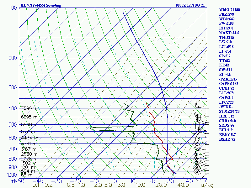
-
August 9-12, 2021 Severe Threats
Chicago Storm replied to Chicago Storm's topic in Lakes/Ohio Valley
Counting this morning, it was the 3rd quality day in a row... So it was bound to end at some point. -
August 9-12, 2021 Severe Threats
Chicago Storm replied to Chicago Storm's topic in Lakes/Ohio Valley
I believe they more-so meant it is a sign that the atmosphere is still somewhat stable to a degree, which meso-analysis supports (If you believe it). 0z DVN sounding coming in shows capping still in place as well, which is likely the reason the activity is struggling in the great environment across E IA. Edit: I'll add that obviously we are still destabilizing a bit more. . -
Figures home would get hit when you're not even there.
-
August 9-12, 2021 Severe Threats
Chicago Storm replied to Chicago Storm's topic in Lakes/Ohio Valley
can head up to the palm kingdom for that. -
August 9-12, 2021 Severe Threats
Chicago Storm replied to Chicago Storm's topic in Lakes/Ohio Valley
Seems evident that activity in WI has been struggling due to the modified/outflow environment that was advected north earlier...An add in maybe a bit of lingering capping as well. -
August 9-12, 2021 Severe Threats
Chicago Storm replied to Chicago Storm's topic in Lakes/Ohio Valley
Green County. Reasoning would have been... Better terrain, is still a quality environment as activity would work in. -
August 9-12, 2021 Severe Threats
Chicago Storm replied to Chicago Storm's topic in Lakes/Ohio Valley
If not for coming off a mid last night at ORD, I'd be sitting in Monroe, WI currently. -
August 9-12, 2021 Severe Threats
Chicago Storm replied to Chicago Storm's topic in Lakes/Ohio Valley
A well defined MCV was evident for a while on DVN/MKX/ILX/IWX.


