
CoalCityWxMan
-
Posts
677 -
Joined
-
Last visited
Content Type
Profiles
Blogs
Forums
American Weather
Media Demo
Store
Gallery
Posts posted by CoalCityWxMan
-
-
Just now, RCNYILWX said:
Not sure I've seen that big of a jump in near term before, but we also saw the large shift in 18z Euro, so something in the data getting into latest guidance. NAM had also been in general running south/colder.
Sent from my SM-G965U using Tapatalk
That is true. If the NAM ends up being right, parts of N IL would be in store for a snow/ice storm that looked to be mostly rain/frz rain
-
 1
1
-
-
What a huge jump south on the NAM. Odd it’s remained so consistent the last few days up till now
-
2 minutes ago, ChiTownSnow said:
NAM rolling in now. Looks like some signific6snt changes in SLP position so far
Way south
-
1
-
-
8 minutes ago, hlcater said:
The 18z Euro just came in and it's wayyyyy south. Like normal with the euro maps I post in here, this isn't mine. Seems that models are picking up on the widespread snowcover hanging things up? Whatever the cause, every 18z run has moved south in some capacity. In fact, it's so much of an outlier I'm almost tempted to ignore it and I probably would if it wasn't an outlier in my favor lol.
We all predicted there’d be a SE trend, just not this late in the game lol
-
Models seem to be coming in a little colder/wetter/south. Wonder if these trends continue with 00z
-
3
-
-
NAM looks to be south/weaker too
-
18z HRRR is a pretty decent bump south compared to 12z. As we know the long range hrrr sucks, but late trends are something to keep an eye on
-
00z NAM looks about the same as 18z so far.
-
Kind of surprised honestly. We’ll see what future trends do
-
Another thing to consider is that this system could potentially have an impact on the cold blast later this week, atleast this far south to some degree.
-
This will be an interesting storm, could be one of those cases where we see icing even if temps are above freezing as mentioned. Wonder what future runs will have to say
-
8 minutes ago, ChiTownSnow said:
Still looks to squeeze out 3-4 inches in N IL. I'll take that and run
Me too. I’d take nothing over a 34 degree snowpack depleting rain
-
The new NAM has bumped south and now keeps much of Chicagoland rain free
-
LOT highlights uncertainty with the system and its track in afternoon AFD, also shares concerns warm air may not make it as far north as some models think.
-
GEFS shifted SE too. GFS has it going from the single digits to 37 in just a few hours. It’s possible, but seems unlikely and I’d also bet on a SE shift
-
1
-
-
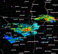
The hrrr just keeps beefing up totals in N IL...
-
Just now, mimillman said:
If the 22z HRRR is right the cut off is going to be extreme in Cook county
3” increase in totals says the HRRR over the last 3-4 runs. But like you said, southern Cook could only see 3” while northern Cook sees 7-8” (not including LE, just talking about the next 20 hours)
-
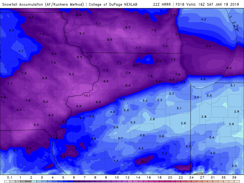
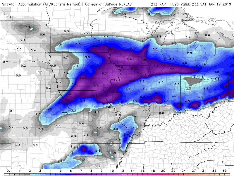
21z RAP looks good for N IL, the HRRR is showing an upward trend as well in recent runs.
-
16 minutes ago, SchaumburgStormer said:
HRRR looks to be a touch north with the FGEN placement at initialization. Probably noise, but makes a difference for those in extreme N IL riding the edge of the line
RAP too. I’ve noticed both the hrrr/RAP are bringing higher amounts further east into IL in recent runs
Edit: If anything, maybe it means the area just south of the band right now will fill in sooner than it’s showing later today
-
It looks like the fgen band may be a little further south than its being depicted by the hrrr/rap. Not sure if it’ll make a difference or not (probably won’t) but something to look at
-
51 minutes ago, DaveNay said:
@King James asked for some perspective on winter storms out in the rural areas of northern Illinois....
Jan 12, 2016
Jan 27, 2014
Feb 3, 2011 (GHD I)
Wow, I wish I had some pics from GHD I But I was only 13 at the time. In my location in rural Grundy there were several 6’ drifts and I remember getting actually stuck in a few of them lol
-
1 minute ago, RyanDe680 said:
LOT
As indicated above, just getting a quick look at the new 00Z NAM
guidance. Fairly similar to previous runs, and continues to
highlight areas along/north of the I-88 corridor across far
northern IL for the greatest snowfall potential with similar
timing going into Friday night. Perhaps a slight (half county)
shift southward with the main frontogentically-forced QPF axis
Friday evening, though basically little change to current
forecast. In collaboration with surrounding offices have made no
changes to going headlines at this time. Midnight shift will have
full suite of 00Z guidance available for possible upgrades.
Looks good from DKB-ORD in the Chicago area
-
1
-
 1
1
-
-
Just now, Hoosier said:
Well if nothing else, I think we can more confidently weight things toward the wetter models in the fgen band. There hasn't really been a significant backing off with that and they should handle it better. Question is exactly where it sets up.
NAM centers it around the I-88 corridor while the hrrr/rap has it further north. Would hate to be LOT tonight, tough call.
-
5 minutes ago, Chicago Storm said:
3km NAM is likely correctly depicting the right gradient with the FGEN band, though totals are still question for now...

.For northern IL:
NAM- 6-9”
3km NAM- 9-14” (lol)
36 hr hrrr- 2-4”
Yikes


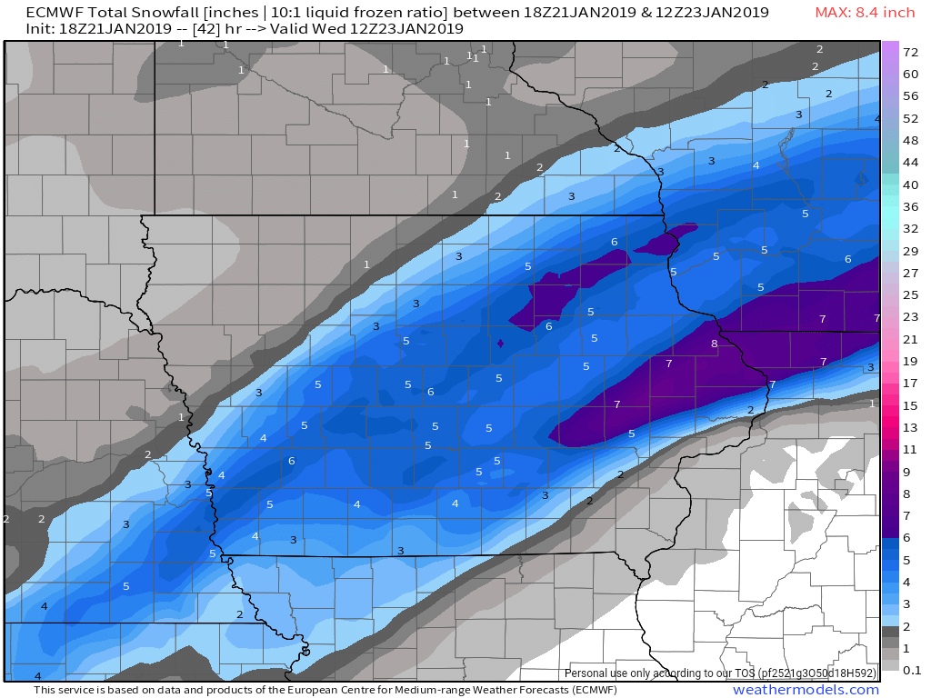
January 21-24 Winter Storm Potential
in Lakes/Ohio Valley
Posted
Can you tell how far south the southern edge of snow moved from 12z?