
CoalCityWxMan
-
Posts
677 -
Joined
-
Last visited
Content Type
Profiles
Blogs
Forums
American Weather
Media Demo
Store
Gallery
Posts posted by CoalCityWxMan
-
-
13 minutes ago, SchaumburgStormer said:

That’d be a nice event for much of the area, sharp cutoff along I-55
-
Closer look for N IL folks
-
 1
1
-
-
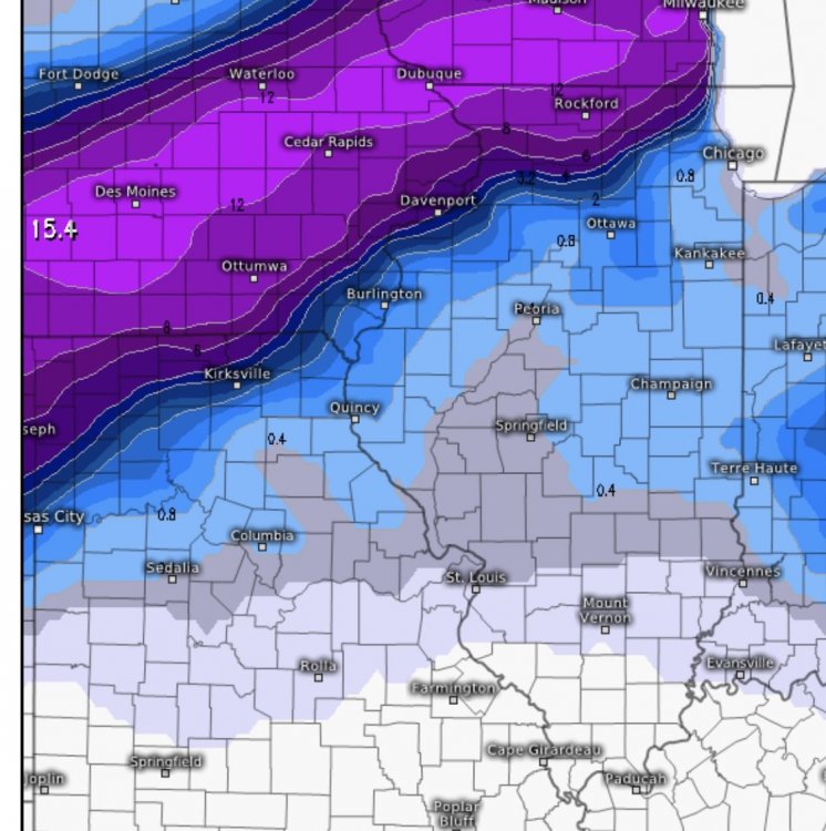
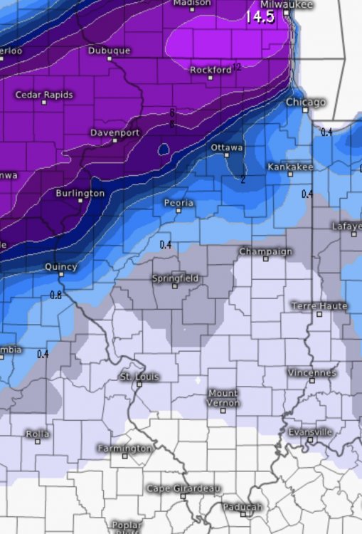
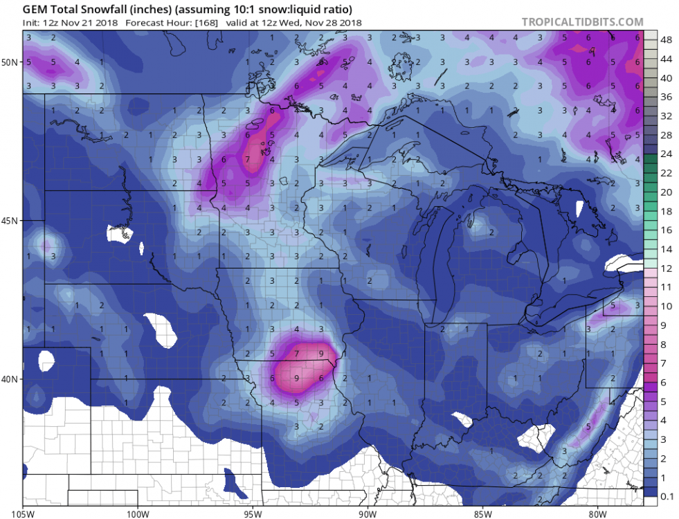
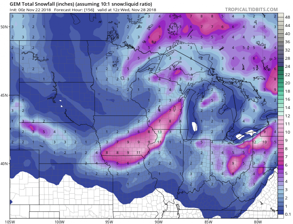
Most 12z runs thus far have bumped SE/are weaker.
-
For comparison, today’s 12z EURO run vs 00z
-
 2
2
-
-
Will be interesting to watch this over the next few days, gonna be nerve-wracking for some on the edge of the heavy totals.
-
1
-
-
Also, Sunday is a huge travel day with lots of people traveling back to college/home
-
The last 3 runs of the GEM have varied just a bit..

-
1
-
-
Gut tells me it’ll shift a *little* SE and slightly weaker than currently projected just based off trends/how these sort of events seem to usually evolve. Probably won’t see much here but wouldn’t be surprised if areas on the border right now (Dekalb-Mendota areas NW) see a good amount from this, especially if that feature Hoosier talked about continues to be more prominent.
-
5 minutes ago, Hoosier said:

Wow. Major snowstorm for Rockford/DVN and NW
-
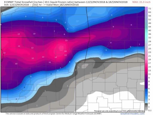
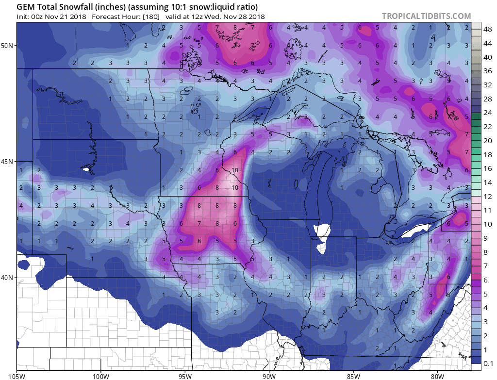
Although it’s still far out, seems to be increasing confidence in a storm system affecting the Midwest/Ohio Valley 5-6 days out. GFS is most aggressive for now but something to watch.
GFS/GEM currently has a 6-12” swath of snow through central Iowa up through southwestern Wisconsin, while the Euro is further SE with a narrower band of similar amounts.
-
1 hour ago, Paulie21 said:

Oh the things I’d do to have this happen
-
1
-
 2
2
-
-
Been a nasty cold drizzle here all day despite a few flakes mixed in here and there. Hoping to get an inch or two of snow tonight though, we’ll see
-
Some models (GFS, GEM, HRRR) are showing 2-3” along/south of the I-80 corridor tonight
-
1
-
-
7 hours ago, Hoosier said:
Almost hard to believe we had this 5 years ago with how this November has been.

I’ll never forget that day, you woke up that morning and went outside and knew something was not right. I’m not 100% sure on this, but I think I remember reading somewhere that the PDS tor watch that was issued for most of IL and some surrounding areas was the first ever issued PDS in the 6AM-9Am time frame or something like that. Again not sure exactly If that’s what it was but I remember reading something like that a couple years back.
-
2
-
-
20 minutes ago, hlcater said:
HRRR is fairly robust relative to the other models and even seems to suggest some convective elements near the changeover zone. Will be interesting to see how this evolves.

It has also been consistently shifting a little south with each run. Last night it kept everything in southern MN/WI
-
1
-
-
13 minutes ago, SchaumburgStormer said:
Short range models, especially the HRRR nailed the narrow pivoting defo band.
Sure did. I was very skeptical until the HRRR continuously was showing it last night. Probably overperformed even with some localized areas seeing 3”+ under the band
-
5 minutes ago, SchaumburgStormer said:
Yeah, looks to stall just west of here and begin to pivot back east a bit. Rip city under the band with light sleet falling on the backside currently.
Yeah it turned to sleep for awhile but snow beginning to take back over as it begins to pivot back east. Might be able to pick up another inch
-
4 minutes ago, Hoosier said:
Looks like it's probably not going to shift a whole lot more in the next few hours.
Yeah the public was unaware too, forecast called for a 40% chance of rain/snow
-
1
-
-
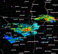
2 minutes ago, Hoosier said:
Band in northern IL looks pretty impressive on radar.
Ripping in dekalb.
-
I don’t recall this wintry of a November in quite some time. I remember as a kid the general “rule” for November was usually seeing a day in mid/late November where a surprise dusting falls, so having repeated cold/snow chances is quite impressive. Can’t complain about the start to winter here
-
1
-
-
The hrrr (and some other models) have been hinting at a narrow, pivoting band of snow lingering in north central/central IL tomorrow afternoon as the system weakens and pulls away. If it ends up happening could give some areas a nice surprise, wouldn’t be surprised if it did due to several models showing a feature like this. Would be a consolation prizes for what folks downstate are experiencing
-
With each run of the HRRR it has been tacking on about .1-.2” of snow with each run for areas NW of I-55. Now up to 2.5+” in the Dekalb area. Tiny differences but nevertheless, can’t wait for it to look like winter 12 hours from now.
-
1
-
-
Things looking up for sure. Don’t remember seeing this wintry of a look in early November in a very long time
-
Both the GFS and GEM agree on a clipper type system coming through the region Friday-Saturday, certainly not the big storm modeled a few days ago but could bring some snow if it happens nevertheless.


Nov. 25th-26th Midwest Snowstorm Potential
in Lakes/Ohio Valley
Posted
00z runs will be interesting.