
CoalCityWxMan
-
Posts
677 -
Joined
-
Last visited
Content Type
Profiles
Blogs
Forums
American Weather
Media Demo
Store
Gallery
Posts posted by CoalCityWxMan
-
-
I feel bad for the farmers..
-
9 hours ago, Minnesota_storms said:
90+ in a week? After some places just got snow.
It’s about time.
-
 1
1
-
-
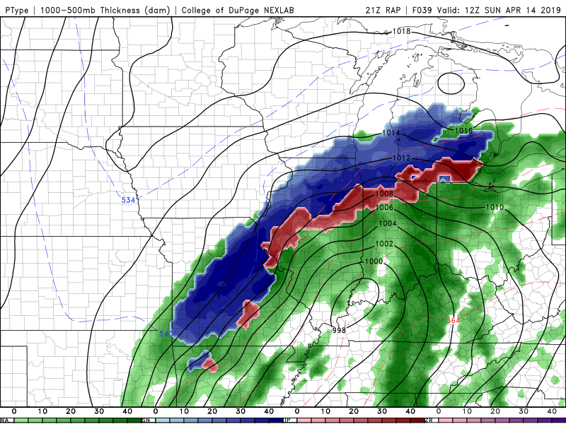
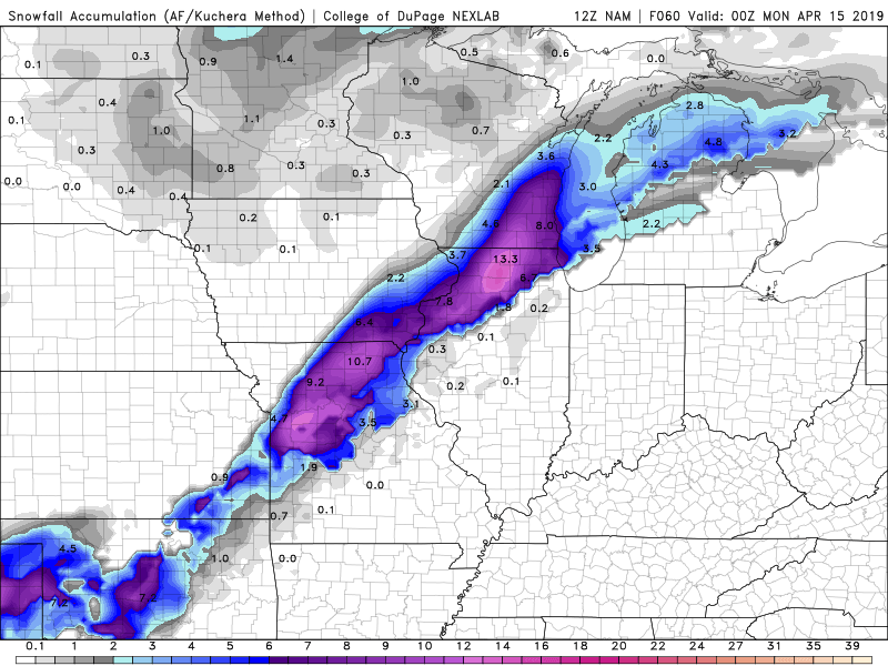
18z NAM a sizable jump south from 12z. Not as far south as a lot of guidance, but definitely trended.
-
1 minute ago, SchaumburgStormer said:
Amounts notwithstanding, I would issue a watch due to the anomalous situation. General public isn't real prepared to deal with potentially significant accumulating snow in late April
Even though we just saw that storm a few weeks ago, the attitude is largely “wont happen” with people I’ve talked to today
-
It’s almost hard to fathom that another significant snowstorm is about to occur this late in the season. The last one was hard enough to believe
-
1
-
-
GEM is pretty far south now too, gives 1” to areas north of I-80 in IL.
-
11 hours ago, SchaumburgStormer said:
Yeah I think that’s probably more to my point. Impacts, rates, total accumulation was spot on. Placement of the heaviest band was pretty solid too, but it didn’t handle the north west edge well in IL, or the northern extent in Wisconsin.
The all-time record for snowiest April in DKB is 8.8” recorded in 1975, so would only take 2.4” to break that. Sycamore had a about an inch more than Dekalb with the last storm they would probably need even less.
-
14 minutes ago, SchaumburgStormer said:
In talking to some friends, no one had any idea this was coming. Most of them expected some flurries.
As was stated earlier, LOT did a real terrible job outlining the risks to the general public. Even the message to those who read the AFD’s was whipping back and forth.
That being said, this is an epic April event.
I’m at work and everyone who’s came in seems shocked. I’ve had many “they didn’t put THIS in the forecast!”
-
Thundersnow in DKB.
-
Surprised there’s no headlines for parts of LOT
-
3 minutes ago, SchaumburgStormer said:
Full blown +SN.
Some of the best rates of the winter lol. If only it were a few degrees colder..
-
Snow/graupel has began with a bang, already accumulating on most surfaces. Swirling around on roads already
-
Wonder if LOT will issue any headlines overnight. If hi-res models are to be believed, some areas could see higher end totals. Don’t think 6+ will pan out, but who knows. Even 2-4” with the rates the hrrr/rap is showing would cause road conditions to deteriorate pretty quickly, even with temps a bit above freezing.
-
4 minutes ago, NTXYankee said:
I thought I saw that occurring on the HRRR model now that it’s within range but looks to follow the same track as others once to Indiana. I guess it’s possible though as it occurs more often than not with the nw trend, especially last minute.
Yeah, like Hoosier mentioned above the SE trend was a little suspicious. Not too surprised
-
Looks like models may be bumping back NW a tad after last nights south trend
-
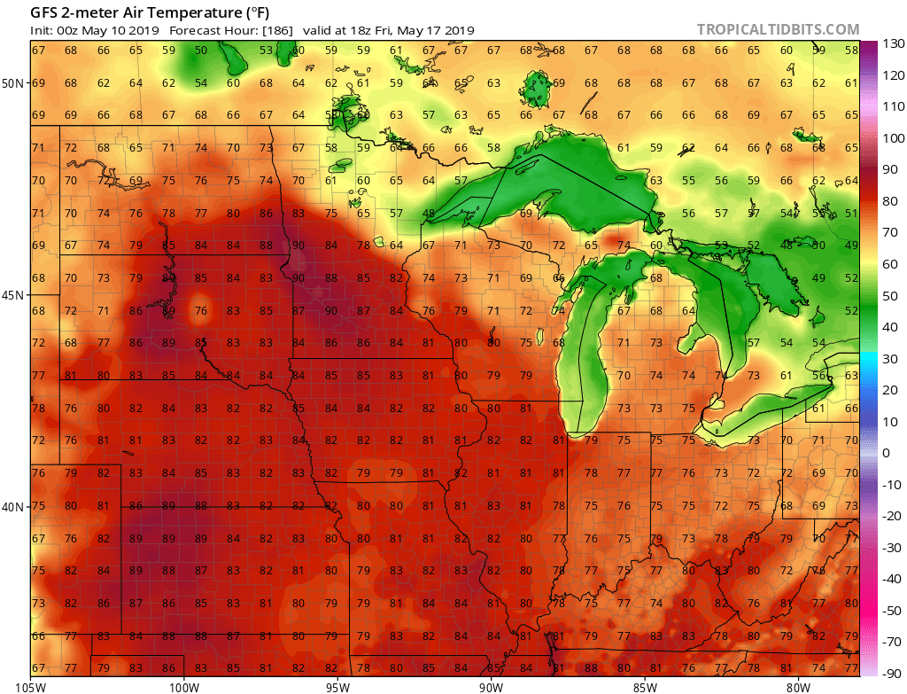
6 hours ago, NegativeEPO said:
Been hearing some talk about a potential year without a summer actually transpiring this year. Is there much truth to that? It wouldn't surprise me tbh.
Yes. Heard it won’t get above 80 all year
-
1
-
 1
1
-
-
The long range RAP looks pretty good for N IL
-
NAM quite a bit snowier..pretty high totals with kuchera method still. Wonder how much would melt/compact right away with most of it falling during the day
-
46 minutes ago, michsnowfreak said:
As a random side note, some parents with school age children are actually looking at this as a harsh Winter. I have a big snow bias, so when you add in how spoiled we've been in recent years and how frustrating this winter's been, I'd be inclined to laugh in the face of anyone calling this anything close to a harsh Winter. But a combination of several perfectly timed snowstorms, 3 ice storms, life threatening cold and a few other intense cold shots, I heard that most school kids have had so many "snow days" that they have to make up some of it before summer. They've had more days off then recent winters were we've had 2 and 3 times as much actual snow fall, makes no sense lol. It does serve as a reminder though that there is more to Winter than just snow.
NIU has had 11 days their campus was closed/opened late just since this semester started the second week of January.
-
1
-
-
Wagons north?
-
3
-
1
-
-
7 minutes ago, hlcater said:
The launch of the FV3 has been delayed in order to try and correct the significant cold bias.
Beat me to it
https://www.weather.gov/media/notification/scn19-12gfsv15.pdf
-
6 hours ago, Hoosier said:
Aurora was sustained at 51 mph gusting to 64 mph at 12:50 pm.
Was on I-88 going through Aurora area during that time, it was pretty awful. Have never had wind push my car around like that before, even in severe storms while out chasing. Have had better experiences driving in snowstorms than that
-
2
-
 1
1
-
-
Here it comes...

-
3 hours ago, weatherbo said:
Brief clearing today between lake snow

How do you even get around at this point?
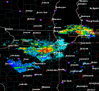
May 16-21 Severe Threats
in Lakes/Ohio Valley
Posted
That thing is easily producing 2” hail I’m sure. Good thing it’s just south of a more populated area or there’d be some costly damage.