
CoalCityWxMan
-
Posts
677 -
Joined
-
Last visited
Content Type
Profiles
Blogs
Forums
American Weather
Media Demo
Store
Gallery
Posts posted by CoalCityWxMan
-
-
32 minutes ago, jlauderdal said:
yep, travelers advisory criteria 1-3, models been in reduction mode, trend is your friend
anyone think any of these locations see over 4 inches of accumulation?
Honestly curious, what models are in reduction mode?
-
 2
2
-
-
told you guys the RGEM was gonna be right
-
 1
1
-
-
(ride the Canadian)
-
6 minutes ago, A-L-E-K said:
You got it
-
FWIW, the RGEM keeps it all snow near/north of I-88. Still snowing at the end of the 06z run too. Again it’s the RGEM but atleast a snowier solution is somewhere in the realm of possibility.
-
1
-
-
00z NAM is an improvement for LOT at least. Still having some weird dry air issues
-
14 minutes ago, Baum said:
This is the point where we get our hopes up for a decent event........
After I saw the 18z GFS I had to promise myself I would not get sucked in this time..
-
1
-
-
Can’t wait for rain followed by subzero temperatures 24 hours later!
-
1
-
 1
1
-
-
 spring can’t come soon enough at this point
-
1
-
 1
1
-
-
GEFS mean took a jump south, seems like most ensembles take the SLP further south than the op run
-
1
-
-
4 minutes ago, michaelmantis said:
I'm looking at the stationary front placement right now over N IL and it looks to go from Waukegan straight to Peoria (it essentially crosses right over me in Elgin, IL). Temp 37 now.
Knife's edge... But assuming temps will stay the same or even warm a bit as the first round come in...
FWIW (probably nothing at all) but the HRRR has been initializing 1-3 degrees too warm for most locations in N IL & has the freezing line a tad too far west in Iowa...like I said probably nothing that’ll make a difference but when you’re forecasting down to a degree the slightest change can make a difference.
-
3 minutes ago, Malacka11 said:
*ape like hooting noises ensue*

...start of a trend.....?

-
2 minutes ago, SchaumburgStormer said:
My kids are going sleet sledding.
Might be more than enough sleet for that if NAM verifies lol
-
-
Just now, Hoosier said:
ICON actually shuts off precip in quite a bit of IL for a while.
Note that it only does snow or rain. Does not resolve sleet/freezing rain.

Looking at sfc temps, looks like it’d have a rather significant area of icing in NW IL with quite a bit of the precip falling with temps below freezing
-
not all hope is lost (yet)
-
1
-
-
4-5” of rain for a good chunk of central IL. Could be more of a flooding threat than anything at this point lol
-
1
-
-
Excited for the prospect of another .4” of snow after the .3” we had yesterday
-
10 minutes ago, SchaumburgStormer said:
Topped at 59 before the crash started at 1400
I should add I’m back home (coal city) for the holidays, I know most previous posts have been from me in DKB, should probably change my name to avoid confusion lol
-
PWS just hit 65, wow.
-
I wonder what the record is for consecutive number of days with atleast 1” of snow on the ground for places like Chicago in November. Could be 5 consecutive days this week if all goes well, have to imagine it’s hard to string together too many more than that this early in the season.
-
Already starting to stick to all surfaces now. Ripping out there
-
1
-
-
Mostly snow in DKB now. Grass starting to whiten up
-
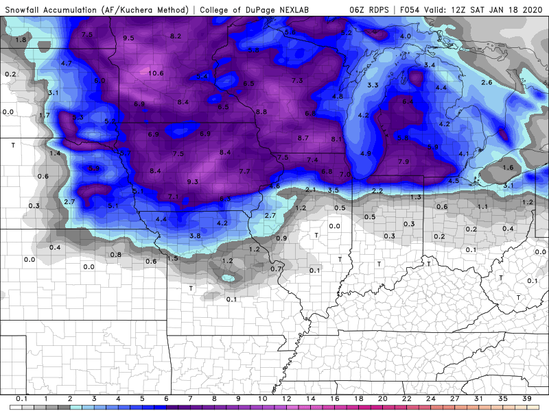
Euro with a nice 4-6” swath through N IL
January 17-18 Winter Storm
in Lakes/Ohio Valley
Posted
Just judging by the posts in here I fully expected models to show a pathetic outcome for LOT atleast before I checked but it seems about the same/slightly better even than last night on most hi res guidance atleast. I know it’s certainly been the trend lately but