
CoalCityWxMan
-
Posts
677 -
Joined
-
Last visited
Content Type
Profiles
Blogs
Forums
American Weather
Media Demo
Store
Gallery
Posts posted by CoalCityWxMan
-
-
Reelin er in
-
11 minutes ago, SchaumburgStormer said:
Absolutely ripping. Best rates of the season, however low that bar is
Yeah if this can continue for awhile might get some decent totals
-
Coming down and accumulating nicely in Dekalb now
-
 1
1
-
-
6 minutes ago, SchaumburgStormer said:
And we are all snow.
Here we go!
-
3 minutes ago, Chicago Storm said:
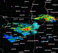
Nice bright band over the Chicago area, with CC rapidly filling in.
.Yeah filling in sooner than i thought it would
-
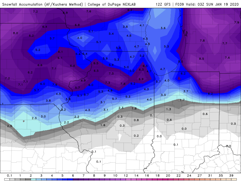
Still liking the Dekalb area for max totals based on where the band will likely pivot
-
00z NAM coming in HOT for Friday night/Saturday it appears. Wow
-
Some pretty good returns (up to 50dbz) in central IL, could translate to some good rates further north.
-
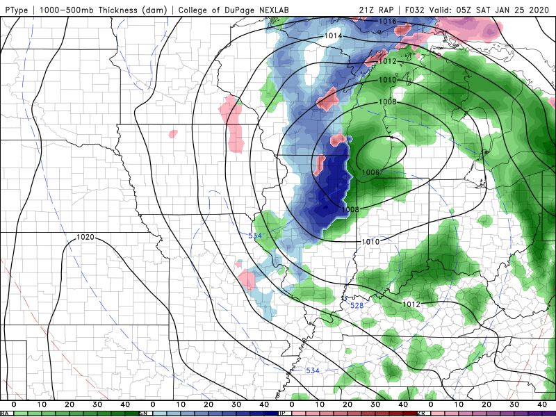
Hello there, 31 hour RAP!
-
The hrrr has been coming in colder/snowier with each run tonight for N IL away from the lake (sorry Alek)
-
1 hour ago, cyclone77 said:
It's looking like the Dekalb/SchaumburgStormer area could be in line for the max totals. Possibly west side of Chicago if trends continue to bump east.
At the moment the EPS/NAM/GEFS all have a bullseye almost right over Dekalb it seems. Will be interesting to see how much the favored area ends up getting
-
Did the NAM break?
-
If the NAM is right, Friday could be a fun day
-
1
-
-
Lock in the 12z NAM
-
Extrapolate the NAM and it’d likely be a nice long duration hit for most of N IL
-
2
-
-
What’re rates looking like... .1” /hr?
-
Pouring rain with a temp of 29. Not ideal
-
Freezing rain/sleet in DKB, spots where snow blew off already have a coating of ice it seems
-
Pretty impressive band moving in from the south

-
3
-
-
Just now, DaveNay said:
DeKalb

Sent from my moto x4 using Tapatalk
Jeez Walmart is even more packed than usual. Gotta get that last minute bread and milk!
-
Just now, A-L-E-K said:
Managed a quick dusting, having cold dry surfaces is a welcome change of pace from trying to accumulate on standing water
Almost seems weird to not have wet slop falling from the sky
-
 1
1
-
-
Latest runs of some hi res guidance keep temps below freezing throughout the entirety of the event for along/north of 88. If we can’t get some of the snow/ice to melt off powerlines & trees before CAA kicks in tomorrow along with potential 40+ mph gusts it may be an issue
-
 1
1
-
-
Hrrr is laying down over a half inch of ice near the I-80 corridor in N IL. Probably way overdone but I feel like even a fraction of that would cause some issues lol
-
1
-
 1
1
-
-
Ride the GFS lol
Feb 12-13 Snowstorm
in Lakes/Ohio Valley
Posted
Long range NAM doesn’t look terrible for much of central/N IL when you think about how awful this season has been