
CoalCityWxMan
-
Posts
677 -
Joined
-
Last visited
Content Type
Profiles
Blogs
Forums
American Weather
Media Demo
Store
Gallery
Posts posted by CoalCityWxMan
-
-
Just now, SchaumburgStormer said:
31 imby with 32 at DKB. Still pouring ZR.
Noticing any power issues by you?
-
4 minutes ago, SchaumburgStormer said:
39 between 80 and 88 is having some serious problems. Wouldn’t surprise me if ISP shuts it down for a bit.
Wouldn’t be surprised if most everything in that area is going to be a disaster by morning, can only imagine with another 6ish hours of this.
-
About .2” of ice in DKB on top of about .7” of snow/sleet that fell earlier. Was surprised things are as icy as they are, as it wasn’t too bad just a couple hours ago. Certainly an interesting night ahead
-
GFS is a bit further south, keeps areas near/north of I-80 mostly/all snow
-
 1
1
-
-
18 minutes ago, IllinoisWedges said:
Both the 0z 12km NAM and 0z HRRR are pretty bigly on ice in the LOT area.
2 ice storms in 7 days

but I will say I think this one has the potential to be worse, with the last storm being a shorter duration/heavier precipitation event limiting accretion.
-
AN AREA OF STRONG THUNDERSTORMS WILL AFFECT ROCK
ISLAND...NORTHWESTERN MERCER...SCOTT...EASTERN MUSCATINE AND SOUTH
CENTRAL CLINTON COUNTIES UNTIL 630 PM CST...

At 547 PM CST, strong thunderstorms were located near Fairport, or
near Muscatine, moving northeast at 60 mph.

Sleet and half inch hail are possible with these storms.

Locations impacted include...
Davenport, Moline, Rock Island, Bettendorf, Muscatine, East Moline,
Durant, Silvis, Eldridge, DeWitt, Milan, Le Claire, Coal Valley,
Hampton, Port Byron, Walcott, Blue Grass, Buffalo, Andalusia and
Rapids City.

This includes the following highways...
 Interstate 74 in Iowa between mile markers 1 and 5.
 Interstate 80 in Iowa between mile markers 280 and 306.
 Interstate 80 in Illinois between mile markers 1 and 4.
 Interstate 74 in Illinois between mile markers 1 and 6.
 Interstate 88 between mile markers 1 and 6.
 Interstate 280 between mile markers 1 and 18.

Torrential rainfall is also occurring with this storm, and may lead
to ponding of water on roadways. With temperatures in the upper 20s
to low 30s, rapid icing is also possible on surfaces.

Frequent lightning is occurring with this storms. Lightning can
strike 10 miles away from a thunderstorm. Seek a safe shelter inside
a building or vehicle.
-
1
-
 2
2
-
-
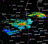
You won’t see a map like this for quite some time at 4:55pm in Chicago..
-
1
-
5
-
-
Just now, andyhb said:
12z Euro run would suggest actually a pretty substantial severe threat next Tuesday in IL/vicinity with upper 50s/low 60s dewpoints present and very strong shear. That would be an incredible flip from today/tomorrow.
It’s almost unfathomable at this point
-
25 minutes ago, RyanDe680 said:
I doubt that would verify with current glacier pack. Would be foggy though.
Was just gonna say, the fog late this week/ early next week is gonna be pretty bad at times.
-
3 minutes ago, mimillman said:
9z SREF mean is just under 2” at ORD...with 11 members over that
Set at the default 10:1 ratio or did you change it?
-
New NAM is quite a bit south. Here we go again!
-
2
-
-
8 minutes ago, Hoosier said:
The RAP and HRRR don't even have data coverage in much of Canada, so yeah, would not be too concerned about them yet. System is getting closer to the US and they should keep correcting.
Also the last few systems they’ve played catch up big time leading up to an event
-
Think LOT will have to extend warnings south a tier?
-
03z SREF ticked south too a decent amount.
If trends continue warnings may need to be extended a county south
-
1
-
-
Anyone have a euro kuchera map?
-
South trend is our friend, still plenty of time
-
2
-
1
-
-
2 minutes ago, Sciascia said:
18z GFS very similar to 12z at 36hrs.
Bump south
-
7 minutes ago, Malacka11 said:
My hopes exactly. 00z tonight will be a nuke going off.
Major changes occurred 12 hours before onset of the last system, nothing is set in stone just yet
-
1
-
1
-
-
GFS is a bit south, gets some better snows near/just south of the low track. CMC May be coming in a bit south too.
EDIT: CMC is actually noteably south, looks to be trying to head back towards where it was before almost
-
3
-
-
Just now, HillsdaleMIWeather said:
12Z 3K NAM is a little south in Wisconsin it looks like
It is. Wouldn’t completely count out a shift south enough to bring some heavier snows (maybe 6-9”) south 50 miles or so. Especially with what happened with the last system.
-
-
Just now, SchaumburgStormer said:
Snowfall lower on the 21z
That is true, I was looking at snowfall mean which did shift south but actual amounts are lower. My mistake
-
21z SREF plumes are a touch south of 15z
-
Well that NAM run was better than I expected, the bleeding needed to be stopped


Winter Storm - February 11-13, 2019
in Lakes/Ohio Valley
Posted
Same here in downtown Dekalb. Don’t think it’s going to be pretty once 40+ gusts work their way in