
TriPol
-
Posts
1,370 -
Joined
-
Last visited
Content Type
Profiles
Blogs
Forums
American Weather
Media Demo
Store
Gallery
Posts posted by TriPol
-
-
Did anyone in the NYC area just feel that earthquake?
-
 1
1
-
-
That was just something... a heavy burst of rain here... wow.
-
33 minutes ago, SnoSki14 said:
Euro/GFS op shows how Atlantic blocking doesn't mean squat when the Pacific is trash.
I expect little to no snows in December. Pattern looks like garbage
The -PDO is a death sentence here
I'm calling for a major snowstorm on December 5 to give CPK 12 inches.
-
1
-
 1
1
-
-
1 hour ago, donsutherland1 said:
A cold front will move across the region tomorrow after a storm brings a general 1.00"-2.00" rainfall with some locally higher amounts overnight. Ahead of the frontal passage, temperatures will likely soar into the middle and upper 50s. A few places will likely exceed 60°.
New York City's annual precipitation, which stood at 49.18" as of 8:39 pm, will surge past 50.00". Years with 50.00" or precipitation have increased dramatically since the City's climate became abruptly wetter in 1972.
The frequency of 50.00" or above years is as follows:
1869-1971: Once every 7.9 years
1972-2023*: Once every 2.3 years
Since 2000*: Once every 1.8 years*Includes 2023 as a 50.00" year. 2023 currently has 49.70". No year had less than 0.30" from November 19-December 31. The record least precipitation during that timeframe was 0.67" in 1955.
Following the storm and frontal passage, somewhat colder air will arrive. Thanksgiving Day will be blustery and cooler, but not harsh. Highs should reach the upper 40s and lower 50s. An even colder air mass should arrive late in the week. Friday night or Saturday morning will likely see New York City experience its first freeze of the season. The remainder of November will likely be generally cooler than normal. However, no Arctic blasts appear likely.
The ENSO Region 1+2 anomaly was +2.0°C and the Region 3.4 anomaly was +1.9°C for the week centered around November 15. For the past six weeks, the ENSO Region 1+2 anomaly has averaged +2.27°C and the ENSO Region 3.4 anomaly has averaged +1.70°C. El Niño conditions will likely continue to strengthen into the early winter as the current East-based event completes its evolution into a basinwide El Niño.
Currently, 2023 is in uncharted territory as far as the ENSO Region 3.4 anomaly and PDO are concerned. The October ENSO Region 3.4 anomaly was +1.59°C while the PDO was -1.71. Prior to 2023, the lowest October PDO when the ENSO Region 3.4 anomaly was +1.00°C or above was -0.36 in 1965.
Should the ENSO Region 1+2 and 3.4 anomalies remain at or above +1.00°C in December, which is likely, and should the PDO remain negative, there is a single past case (1950-2022) with similar conditions: December 1972.
The SOI was -18.07 today.
The preliminary Arctic Oscillation (AO) was +0.535 today.
On November 19 the MJO was in Phase 8 at an amplitude of 1.564 (RMM). The November 18-adjusted amplitude was 1.507 (RMM).
Based on sensitivity analysis applied to the latest guidance, there is an implied 87% probability that New York City will have a cooler than normal November (1991-2020 normal). November will likely finish with a mean temperature near 46.2° (1.8° below normal). That would be New York City's coldest November since November 2019.
Any chance of 55 inches this year? A wet December?
-
1 hour ago, Allsnow said:
Upper 30’s low 40’s for thanksgiving
Should make for a breezy parade
-
Any chance the volcano in iceland impacts our weather?
-
Sold!
-
1
-
 1
1
-
2
-
-
4 hours ago, MJO812 said:
Gefs and geps are starting to show a colder pattern near Thanksgiving.
Hopefully not a windy one. Don't want anything to happen to the parade.
-
1
-
2
-
-
Down to 35 here
-
8 minutes ago, CIK62 said:
Part left-overs from Tammy? Storm is going eastward here.....

The GFS is on some premium quality stuff this morning:
-
1
-
-
Well, howdy there...
-
1
-
-
4 hours ago, SnoSki14 said:
So much for a Nino pattern
Don't we want a high pressure over the aleutians this time of year?
-
1
-
-
-
This went way further north than originally predicted.
-
Stick a forky in it. We’re not getting more than an inch.
-
1
-
1
-
1
-
-
51 minutes ago, CIK62 said:
While Orphelia may be in our vocabulary for just days-----the first week of October on the GFS which was to start in the 80's-----is now starting in the 60's with multiple chances of another TS. Rainfall exceeds 8" over the next 16 days!
BN Octobers may mean an AN winter, I think, say 60%.
We've had AN Octobers for years without any snow. I need snow. Give me snow! I'm addicted to that white powdery substance in a way I can't describe! Oh wait..
-
1
-
3
-
-
22 minutes ago, Stormlover74 said:
What below average temps?
It's not getting any warmer than the 60s today. Low-mid 70s all week.
-
If this rain keeps up and we continue to get below average temps, we’re in for amazing fall foliage, the likes of which hasn’t been seen in a long time. Get your cameras ready!
-
1
-
 2
2
-
-
I really enjoy the sounds of the rain at night. So quiet and peaceful.
-
2
-
-
I've been involved in meteorology for decades. I have never seen a storm rapidly intensify like this. Would be interested to see SSTs after Lee has passed.
-
1
-
-
7 hours ago, forkyfork said:
sure why not let's ruin a heat wave with a due west moving freak storm

If this doesn't verify, it'll be more disappointing than Viennetta ice cream.
-
1
-
1
-
-

A little pocket of 31.5-32.5C water temps. Basically 90 degree water temps.
-
1
-
-
9 hours ago, donsutherland1 said:
2019 was NYC's last cooler than normal August. August 2023 will be the coolest August since August 2017. Both August 2017 and August 2019 were followed by a warmer than normal September.
I don't remember much about the preceding winters, so that can't be good.
-
1
-
-
I'd wager a hefty sum that the likelihood of a landfall event in the Florida Panhandle is rather minimal, a hypothesis that I find somewhat at odds with the current projections from the National Hurricane Center. Since the case of Hurricane Charlie, Gulf-originating hurricanes to veer westward in their tracks, particularly when their initial trajectories are not aimed at Texas, Louisiana, or the Mississippi/Alabama coastline. This westward bias is often less pronounced when a robust anticyclonic system is situated over Florida, effectively serving as a protective barrier for the state's western coastline. One could argue that the NHC's forecasting methodology could benefit from a reevaluation of these recurrent patterns, especially in the context of recent advancements in ensemble forecasting and data assimilation techniques.
-
1
-
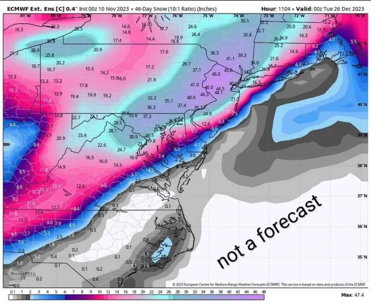
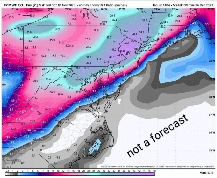
December 2023
in New York City Metro
Posted
December blizzard confirmed.