

Blue_Ridge_Escarpment
-
Posts
2,200 -
Joined
-
Last visited
Content Type
Profiles
Blogs
Forums
American Weather
Media Demo
Store
Gallery
Posts posted by Blue_Ridge_Escarpment
-
-
4 minutes ago, Sandstorm94 said:
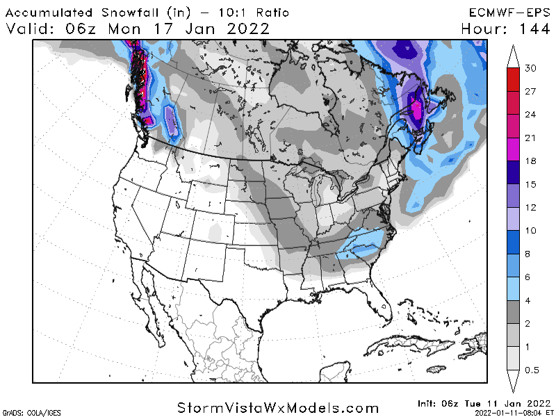
FYI 6z EPS cut the totals again
Sent from my SM-S115DL using Tapatalk
Less amped = less precip. Run was colder
-
 1
1
-
-
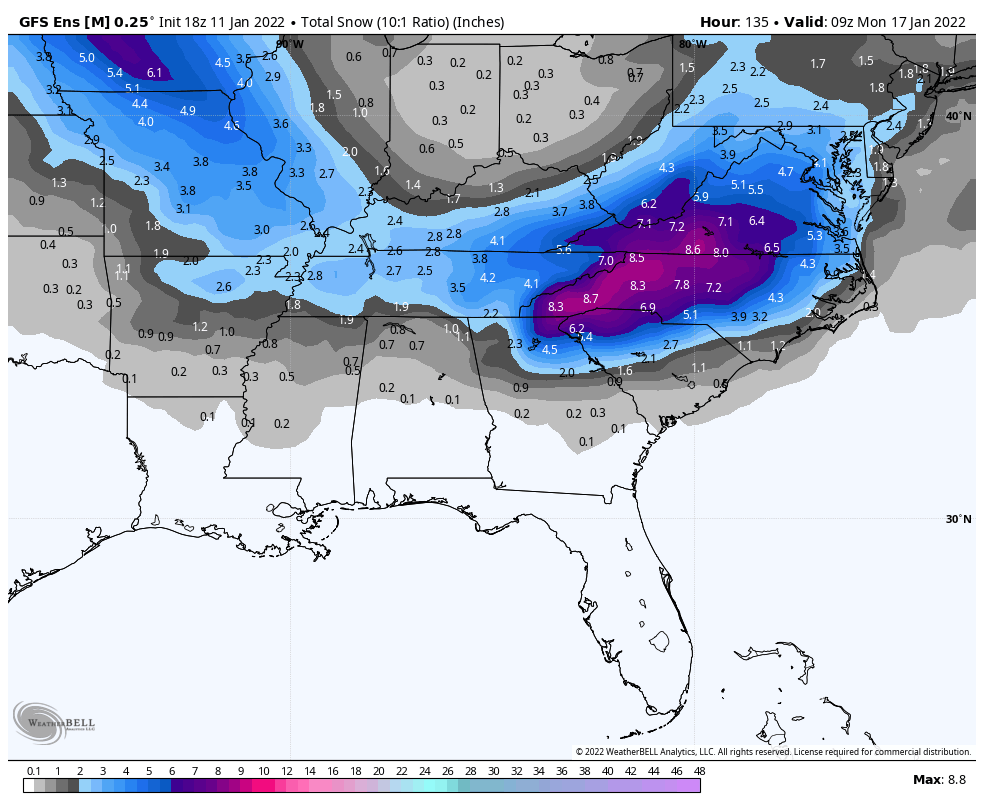
Snow totals gonna be insane on the GEFS this run for the mtns.
-
4
-
-
2 minutes ago, BooneWX said:
Anybody have the GEFS map?

-
4
-
 1
1
-
-
3 minutes ago, buckeyefan1 said:
GSP

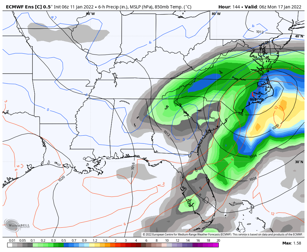
.LONG TERM /SATURDAY THROUGH TUESDAY/...
As of 240 pm EST Tuesday: Looking ahead to the weekend, all
attention turns toward the possibility of a winter storm that would
affect the western Carolinas and northeast Georgia beginning perhaps
as early as Saturday afternoon and possibly continuing through the
better part of Sunday...emphasis on the word "possible". It is worth
noting that the 12Z ECMWF has come around to the GFS idea that a
strong short wave dropping southeastward along the High Plains would
ultimately cut off an upper low over the central/srn Plains Friday
night into Saturday. Also worth noting is the relative run-to-run
consistency seen in the operational GFS with this feature. The
setup begins Friday night into Saturday as the developing split in
the flow helps to slow the progress of a large continental sfc high
moving from Ontario, down across the lower lakes, to Upstate NY/New
England Saturday/Saturday night. This would provide the necessary
source for cold air prior to the arrival of the precip associated
with the upper low, which operational guidance suggests will come
across the lower MS Valley region Saturday night. The operational
models show partial thickness values low enough to support at least
a mix with wintry precip as we acquire isentropic lift on Saturday
that could force the development of said precip by the afternoon. If
this develops as it could, essentially as an activating warm front,
it would help to lock in the cooler sfc temps before the main
mid/upper forcing arrives from the west. The operational models all
show a closed upper low rolling east on Sunday, moving overhead or
to the south of the fcst area, then offshore/northeast on Sunday
night. Be that as it may, this is not the only possible solution,
and some of the ensemble members show very different outcomes
to the upper/sfc pattern. Looking at the GEFS...there has been
a definite trend toward more wintry precip across more of the
fcst area, with the majority of ensemble members at 12Z showing
wintry precip affecting nearly the entire fcst area Saturday
night/Sunday. The plume diagrams, and their supposed total snow
accumulations, appear most tantalizing. However, there are as many
ensemble members showing minimal wintry precip as there are showing
a great deal, and some still showing none at all. Our forecast will
reflect developing confidence in the wintry scenario but limits
the precip probs to the chance range for the time being. The trend
is toward more of a snow possibility along/north of I-85 and more
mixing/changing to sleet/freezing rain south of I-85, but this is
only one scenario. The track of the low will determine how strong
of a warm nose might develop from the south, which would greatly
affect the precip-type distribution. The QPF blend right now is
especially modest, and the conservative approach is preferable
for a system that is still out on Day 4/5. In spite of the trend,
readers are cautioned to manage their expectations...at least for
the time being. Stay tuned.

If this system develops as it could, we would be in for some NW
flow snow on the TN border Sunday night into Monday, otherwise
the remainder of the period would be quiet with a large sfc high
settling across the region Monday into Tuesday.
I wish I could have a facepalm reaction to the bold statement. We can’t find a model now that doesn’t show warning criteria snow so we are picking out individual ensemble members. Wut?!
-
 2
2
-
 1
1
-
-
8 minutes ago, Lookout said:
UK is south but a lot of snow in ga and sc. Although the differences are certainly there, considering this is still 4 to 5 days out, I feel like there is remarkable agreement. Sure wouldn't get hung up on any one run or model though
Yeah it’s south but definitely north of its 0Z run. Probably playing into its suppression bias.
-
1
-
-
Going to be a warmer run for sure. Just don’t know how much warmer yet.
-
Just now, Disc said:
ICON will be a big hit for southern VA.
2 feet at GSO-
1
-
 3
3
-
-
Have a seat and close the blinds before you look at the ICON snow output.
-
4
-
-
1 minute ago, Buddy1987 said:
Eh nothing else to do might as well. Blue Ridge is right tho def trending toward GFS with the evolution.
Yeah icon actually IMO has gotten worse as a model as a whole. Use to be fairly decent but it’s definitely always too warm at the surface.
-
1
-
-
ICON really consolidating the energy back west this run.
-
Just now, olafminesaw said:
Gotta iron out the vort track, strength etc. before it's even worth thinking about precip type issues. Always an issue when it comes to the big ones, which is why we don't mind an EPS-like solution
Well the 6Z EPS is moving toward the GFS in a hurry. The 6Z Euro control was almost carbon copy GFS.
-
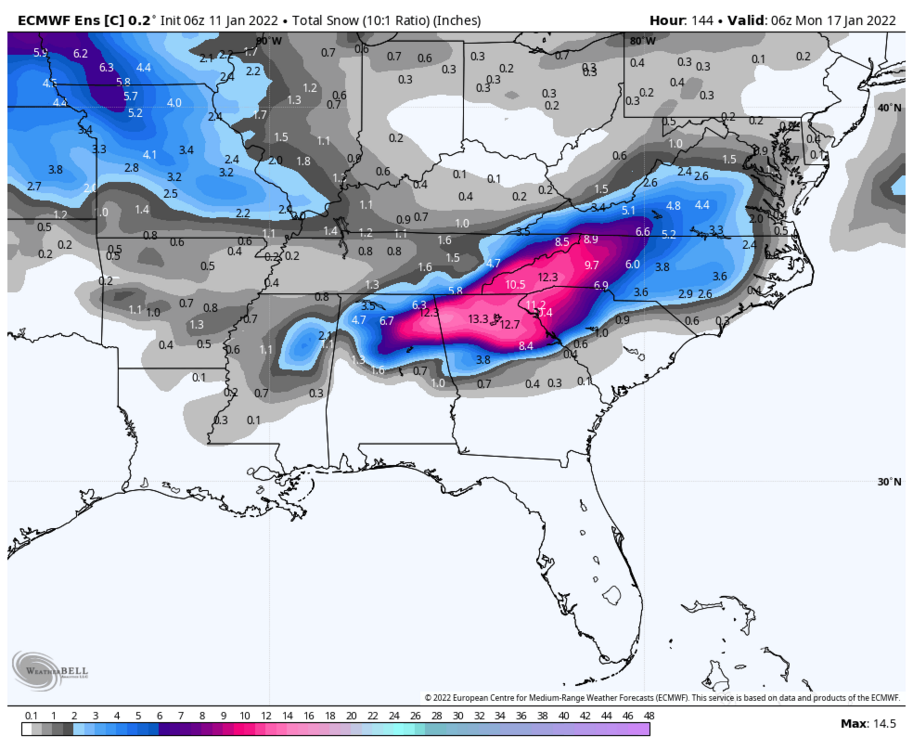
Y’all like deform bands?

-
12
-
-
6Z euro control run, mercy!! And still snowing.
-
11
-
-
1 minute ago, burgertime said:
6z EPS again goes towards the GFS. Not the monster GFS is but a nice low track with an I-85 special. RDU east across much of the state is 4+. Not so far east with that 4+ as the 00z. Sorry @ILMRoss
As you mentioned, not the bomb the GFS has YET. But, definitely a big step toward it.
-
2
-
-
Just now, burgertime said:
Thanks for the pbp burger. Just like it use to be!
-
2
-
-
2 minutes ago, wncsnow said:
The UK looks nothing like the GFS and shows little moisture
Precip is there it’s just south. Playing into the bias the UK has. At H5, it was definitely an improvement.
-
2
-
-
6 minutes ago, wncsnow said:
Eastern NC jackpot with 2 feet+
This would double your yearly average in Marion. Wow.
-
1 minute ago, CntrTim85 said:
I haven't had a good snow since January 2018 and next week I'll be in Disney. With my luck, you will all get blasted all the way to the coast. Good luck!
I’m actually flying out a week from today to Disney as well. Hoping for a big snow to send us off.
-
1
-
-
The GFS ensemble mean is absolutely loaded. Wow.
-
3
-
-
1 hour ago, wncsnow said:
Long range still not impressive on operational models
This didn’t age too well…or maybe it did
")
-
In regards to Euro…..BOOM
-
3
-
3
-
-
Just now, wncsnow said:
Yea that was pretty amazing. Parts of VA got almost 4 feet....
A snow like the GFs showed in NC would double or triple a lot of peoples yearly average. Wow
-
2
-
-
It’s absolutely ripping it here right now. Temp dropped about 7 degrees in 45 mins.
-
2
-
-
The NAM has been awful since it’s “upgrade”, there’s really no debating that. It actual has a dry bias now.
-
1
-

Jan 15-16 Winter Storm
in Southeastern States
Posted
That is +++snow overhead