
Blue_Ridge_Escarpment
-
Posts
2,200 -
Joined
-
Last visited
Content Type
Profiles
Blogs
Forums
American Weather
Media Demo
Store
Gallery
Posts posted by Blue_Ridge_Escarpment
-
-
3 minutes ago, eyewall said:
I am not sure why everyone excited about ice lol.
Definitely has me a bit worried with such a strong signal showing up on the globals at this lead time. Usually tends to be a bit stronger signal once mesoscales get in range.
-
1 minute ago, Sandstorm94 said:
2/30 down my way, .2 and .5... That tells you all you need to know...
Sent from my SM-S115DL using Tapatalk
Yeah this is definitely more of a CAD favored area pattern
-
 2
2
-
-
6 degrees. Would have made a run at 0 if the wind would have went calm.
-
1
-
-
Just now, Leesville Wx Hawk said:
NAO positive unfortunately and HP not favorable.
1043 to our NE and a 1035 meso over VA looked pretty favorable to me.
-
5
-
-
Big CAD event on GFS day 8
-
2
-
-
About State winning today…
-
 1
1
-
-
11 minutes ago, WinstonSalemArlington said:
Am I correct that this month’s events have not been classic Carolina snows?
I would say they haven’t been the textbook Miller A’s that you’d typically see for widespread NC. Just enough dynamics in play to make it work.
-
 1
1
-
-
2 minutes ago, eyewall said:
Yeah I see what you're saying. We will see if that can battle the SE ridging enough to get the job done. Of course that would most likely be more in the way of mixed-p/ice if it does materialize, but that is certainly more of the norm when it comes to winter weather out here.
Correct me if I’m wrong but seems that majority of solid CAD events come at the tail end of a warming period. We are going to see that mid next week.
-
1
-
-
1 minute ago, eyewall said:

Mostly a whiff for now but otherwise before that it is ridging and systems riding that to our north.Definitely think there is a solid CAD event within the next 7-14 days. Lots of signals from the globals.
-
3
-
-
2 minutes ago, msuwx said:
Prior to this winter, I don't think there has been a more prolific screwzone in the region than the Charlotte metro....especially western and southern Charlotte metro. It's nice to finally see that reversed a bit.
I believe I saw some speculation that the increased air traffic at Charlotte Douglas may play a role in that? Specifically in regards to BL temps.
-
4 minutes ago, eyewall said:
Congrats all from the screw zone. What a joke this ended up being here.
You’re just going to have to pack up and move to some climo favored area.
-
1
-
-
3 minutes ago, wncsnow said:
It looks like parts of Buncombe county got more than Banner Elk
Judging by the webcam in banner elk, definitely agree.
-
Just stepped outside and it is absolutely ripping out there with some gale force winds.
-
2
-
-
6 minutes ago, PantherJustin said:
Ok …. Greater chance of occurring…. Someone gets 3-6” in this Mystery band none of us can see, or NC State “Upsets” (If you wanna call it that) UNC Tomm in the Dean Dome while they honor Ole Roy?… or Option 3 I just lose everything this weekend

If Roy is in the building State loses. Been that way for over 15 years now.
-
1
-
-
3 minutes ago, Avdave said:
Knock off 20% QPF on the NAM. It loves to overdo QPF
It use to, not so much anymore.
-
 1
1
-
-
7 minutes ago, wncsnow said:
Can anyone post the 18Z euro for WNC?
-
3
-
-
Wow, 3k NAM!
-
1
-
-
1 minute ago, wncsnow said:
Even Boston could be sweating this out if it keeps trending east
I’m thankful back this way at least here in the mountains we aren’t relying on that LP
-
2
-
-
Starting to look like you want to be in two places. Mtns of WNC or extreme NE NC.
-
2 minutes ago, BornAgain13 said:
Absolutely. It was nice watching the NAM put on a show but it was the 84 hr NAM, and nothing else was showing that much.... still got time but it looks like a minor-moderate event possible.
I’ll take the nice event the euro is showing and call it a day.

-
3
-
1
-
-
Just now, TARHEELPROGRAMMER88 said:
ICON is also not good. On to the global models. ICON did shift the low west.
ICON was improved at the H5 level. Improved the past 3 runs.
-
1
-
-
5 minutes ago, BooneWX said:
The trend is our friend. We’re oh so close!
Yep. All you gotta do is loop the H5 maps and see how this is trending. Also, the surface is under done even on that NAM run.
-
1
-
-
The trends are still going. I don’t see a whole lot stopping it from coming even further west.
-
3
-
1
-
-
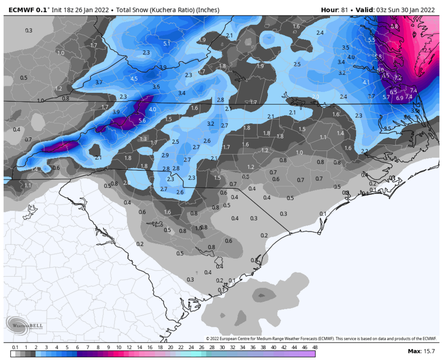
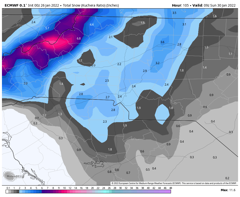
I sure hope the euro is right for this weekends event. Shows a really good snow for the mountains.

2021-2022 Fall/Winter Mountains Thread
in Southeastern States
Posted
Can we trend this to sleet at least? I enjoy my power.