ragtop50
-
Posts
148 -
Joined
-
Last visited
About ragtop50

Recent Profile Visitors
2,126 profile views


-

The “I bring the mojo” Jan 30-Feb 1 potential winter storm
ragtop50 replied to lilj4425's topic in Southeastern States
Per Greg Fishel on Raleigh area I have to be very careful the way I word this. As I have stated from the beginning with this storm, it's not a textbook case. There are a lot of unique qualities and idiosyncrasies that are causing a lot of meteorologists, including myself, to tear their hair out! The general consensus is that the higher the resolution of a model, the better the forecast. And a lot of times that's true. It's like taking a picture of houses on the other side of a lake. The lower resolution camera will see 4 houses as 1, while the higher resolution camera will see all 4 houses clearly. But sometimes, as a former colleague of mine once said, higher resolution forecasts lead to more detailed errors! it is true that the high resolution guidance is killing this event for the Triangle. But the actual observations across the state are already contrasting with what these models are showing. Sometimes you have to take a step back and think about the meteorology and not just regurgitate model output. Having said that, could I be wrong with my 4-7? Sure could. But even if that happens, I will not change the way I forecast the weather. If my job was solely to read a map and share those numbers wtih you, how much value do I have? I would hope you would expect me to go beyond that and attempt to add a human element to my forecast. So I'm sticking to my guns. If I'm wrong, I'll be the first to admit it. With the kind of solid to liquid ratios we're looking at, were not gonna need a ton of precipitation to achieve those totals. Time will tell. Thanks for reading. I'm making this post public so as many people as possible can find out about the product I offer here. -
The “I bring the mojo” Jan 30-Feb 1 potential winter storm
ragtop50 replied to lilj4425's topic in Southeastern States
Old information. Fayetteville will probably never get over some of it's past reputation, but it is nothing like it used to be. -
The “I bring the mojo” Jan 30-Feb 1 potential winter storm
ragtop50 replied to lilj4425's topic in Southeastern States
I will, just had the rugged pulled down here too many times -
The “I bring the mojo” Jan 30-Feb 1 potential winter storm
ragtop50 replied to lilj4425's topic in Southeastern States
During the Raleigh NWS briefing (posted on YouTube), they touch in this and emphasize that there very well could be a dry slot somewhere and that some people could end up with less than they are forecasting, but how do you put that on a map when you don't know where and to what degree (and it keeps changing)? So their amounts are outside of that happening. And just the same they mentioned some areas could obviously be higher. -
The “I bring the mojo” Jan 30-Feb 1 potential winter storm
ragtop50 replied to lilj4425's topic in Southeastern States
GFS says it is going to die on this hill if necessary -
The one with 26 is probability of snow over 4 inches, not actual snowfall. Trust me, I got excited with that one at first as well!
-
January 20-22 “bring the mojo” winter storm threat
ragtop50 replied to lilj4425's topic in Southeastern States
Few flakes flying around here just north of Fayetteville in Linden (northern Cumberland County) -
January 20-22 “bring the mojo” winter storm threat
ragtop50 replied to lilj4425's topic in Southeastern States
RAH update, mentions the updates to warnings would later if done .NEAR TERM /THROUGH TONIGHT/... As of 930 AM Friday... Just minor changes this morning as we await a full suite of new 12z- initialized guidance. Observational datasets confirm the near term forecast trends. The latest surface analysis shows the frigid high nosing strongly down through central NC with plenty of dry air advection, including single-digit dewpoints just to our N. Skies are just cloudy, with radar showing spotty elevated returns across the S half, although most of this is likely not reaching the ground given the somewhat dry subcloud layer noted on 12z soundings. Will maintain low chance pops across the SE well into the afternoon, before trending pops up with a NW expansion as we approach the evening. Any changes to the advisory or warning will wait a few more hours when further high res guidance can be fully considered. Expect temps to hold firm or rise just a degree or two today, yielding daytime highs of 27-34. Current brisk winds from the NNE and NE with occasional gusts to around 20-25 mph will persist through the day as the dense air pours in with a strong ageostrophic component, which will keep wind chills in the upper teens to mid 20s for much of the day. -GIH -
January 20-22 “bring the mojo” winter storm threat
ragtop50 replied to lilj4425's topic in Southeastern States
I am not sure that having those two in your camp vs GFS/NAM is a great position to be in, I feel your pain -
-
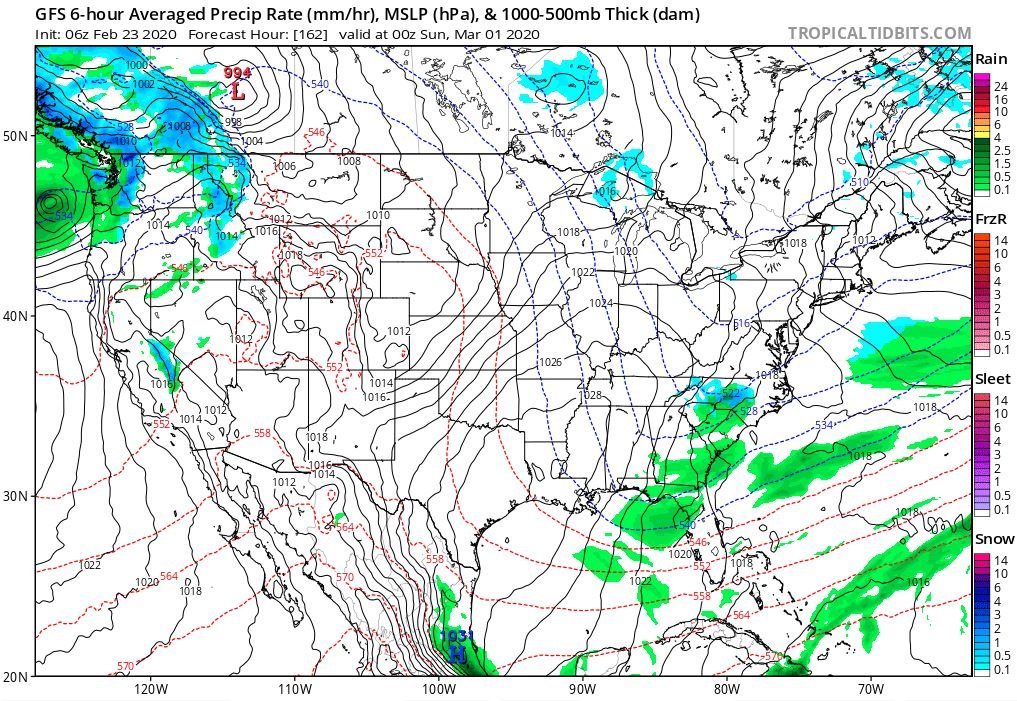
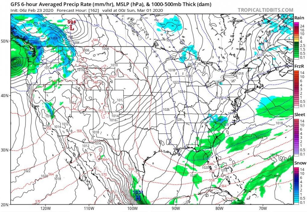
GFS is trying for March 1st
-
1960, 1980, 2000... Continue that trend....we are due ! Not all were March but big snows those years
-
RAH not biting: Mid and high level moisture will increase rapidly on Thursday ahead of a positively tilted trough digging through the Midwest. Precip will spread along the stalled frontal zone over the SE US, with cyclogenesis induced off the SE coast. Models continue to trend a a bit closer to the coast with the surface low bringing more moisture inland. The low is still relatively weak, however, and moves east with the digging trough. The bigger question is whether or not the arctic air associated with a 1045+ mb high over the central US will spill across the mountains in time to cause a mix of rain and snow or changeover to rain. The high is not in a favorable location for the dense cold air to make it into NC very quickly...likely having to filter across the central Appalachians and south through VA...and so the probability of probability more than a rain/snow mix appears very low at this time. If there is an opportunity for phasing of sufficiently deep moisture/omega and cold air, it would be north and east of the Triangle, which is where the outlier EPS solutions lie..while the the GFS and GEFS appear to be too aggressive with with cold air.
-
RAH discussion this afternoon concerning next week: The aforementioned cold front/frontal zone is expected to settle to the south of the area on Wednesday into Thursday as cold high pressure builds into the area. The will allow for high temps to be in the 40s late week, with low temps possibly in the 20s by Friday morning. With regard to chances for precip, additional s/w energy is expected to dive south/southeastward out of the upper Midwest and potentially drawing the stalled front to the south back northward and allowing for chances for precip Wednesday into Thursday, with dry weather expected again by Friday. The latest ECMWF keeps central NC dry (with any precip to the south), while the GFS spreads precip into our area. If precip does spread back into our area, we could see a threat for some wintry precip, with possibly even some snow across our area (even southern locations). Thus, there remains a lot of uncertainty in this portion of the forecast, but will keep the precip all liquid in the forecast for now and lower temps some. Stay tuned.
-
Mid 70's here as well