
Thanatos_I_Am
-
Posts
1,348 -
Joined
-
Last visited
About Thanatos_I_Am

Recent Profile Visitors
3,894 profile views


-
Feb 22nd/23rd "There's no way..." Obs Thread
Thanatos_I_Am replied to Maestrobjwa's topic in Mid Atlantic
You wouldn’t have enjoyed a cold rain with a few mangled flakes mixed in? -
Feb 22nd/23rd "There's no way..." Obs Thread
Thanatos_I_Am replied to Maestrobjwa's topic in Mid Atlantic
Insane micro-climate going on around DC. Mostly rain, wintry mix on the national mall. Drove over the bridge and moderate snow in Rosslyn. Interesting! -
Feb 22nd/23rd "There's no way..." Obs Thread
Thanatos_I_Am replied to Maestrobjwa's topic in Mid Atlantic
The saddest wintry mix you’ve ever seen in Navy Yard. -
Feb 22nd/23rd "There's no way..." Obs Thread
Thanatos_I_Am replied to Maestrobjwa's topic in Mid Atlantic
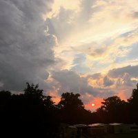
In Oxon Hill at the moment. All rain. Depressing! -
Appreciate the insight. Trying to follow here, is the advection lobe you are referring to the feature over the Midwest? I see the issues in SE Canada, just want to understand the first part of your post. Thanks!
-
12z AIGFS didn’t quite get it done but trough appears to tilt negative sooner. The smarter folks can comment but have to imagine that was a step in the right direction.
-
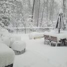
An inch in Cumberland and over a foot in DC. Even more of a reason to hope the GFS is right. The panhandle gets screwed and we win.
-
Are we sure we want him back? Keep him on the metro if CMC/UKIE improve, IMO.
-
Exactly my (albeit uneducated) thoughts. Seems like the SLP mean is being dragged by some outliers east. That’s a lot of lows hugging the coast. Not sure we can reasonably ask for anything else at this point.
-
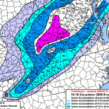
Appreciate the quick post with comparison, Will. Trend is our friend here. Based on MSLP maps there was a good shift of members towards the coast. Baby steps!
-
Already seeing snowfall maps making the rounds on Twitter and other platforms. We need to limit access to this information for the general public, lol. Hilariously stupid to post these so early in a forum like that!
-
12z ICON suite made a big step towards the Euro solution. Hopefully we can get the CMC or UKIE on board!
-
Do we have access to the 6z operational run?
-
Things you’ll see in the observation thread Sunday: - The sleet line racing north ahead of schedule - “Hearing pingers in College Park” (4-6 hours before they were forecasted to mix in) - The folks in Frederick measuring snow in feet - DCA reporting a 6” storm total - Various posts from new accounts asking how the forecast was so wrong - The same old “looks like the fall line was the cutoff” postmortem Cannot wait!
-
You can almost feel the rug pull coming. Slow ticks north up until game time. Those of us in the district get our 3-5 inches of slop and the NW burbs/MD line pummeled. We’ve all seen this movie before


