SteveVa
-
Posts
355 -
Joined
-
Last visited
1 Follower

About SteveVa

- Birthday December 5
Recent Profile Visitors
3,252 profile views


-
Remember Jan 17/18 event this year? I was laughing at NAM and RAP consistently dumping 10" over OBX...and then OBX got crushed. I wouldn't be so quick to disregard the NAM in this instance, although that event had more cold air to work with
-
Here is the excerpt from AKQ FD...very conservative as usual. Have also kept the RIC metro in the 1-2 inch range for now. May need to issue advisories to the north of the warning and also likely just east of the I-95 corridor, but will hold off doing so until this afternoon to examine the new guidance coming in to determine the areal extent of the advisory. As far as ORF goes, it's looking like a lot of cold rain. Low level NE/ENE flow off the 50 degree ocean is certainly not doing us any favors. I'm still open to the possibility of a slushy coating if the precip rolls in early enough in the morning. Good luck to everyone!
-
Found it. Sampling makes no difference according to this study, looks like another one of those "6z/18z model runs are inferior" myths that might have been true a while ago.
-
Speaking of sampling, didn't @dtk at one point debunk the theory that models are less accurate if the shortwave is over an area with almost no in-situ observations?
-
Yup, just like most offices in the SE when it comes to winter weather. I was surprised to see that the NWS GSP map was legit, would never expect AKQ crew to do the same
-
I could definitely see a front-end slushy inch or so for ORF and ECG. Something like the 18z FV3 depicts. There is also a possibility of frozen precip for our area on the back side, but models are still all over the place after the low pops into the Atlantic. AKQ is, unsurprisingly, fairly conservative and calls for all rain.
-
That's fake news. Map from 6PM today shows barely 1" https://www.weather.gov/gsp/winter
-
Looks like it's all done here in Norfolk near ODU campus. We had a moderate burst of snow around 12:30 that lasted for about 15-20 minutes before precip tapered off. We got a slushy coating on grassy surfaces, but it's long gone now as temp never fell below 33.
-
It's been snowing off and on for about an hour in Norfolk with rain occasionally mixing in. Temperature went from 43.0 to 36.9 since 11am. We could have probably scored a coating had the timing been better.
-
Ahh, JB's kiss of death for NC and VA.
-
Mods, can we curb constant MBY questions? I'm just sifting through them even though the snowfall map has been posted--it's getting slightly annoying
-
Got down to 38 once more early this morning. I'd assume we're in for a snow storm later today if I couldn't see the temperature (or the calendar lol) Overcast, calm, and chilly.
-
Got down to 38 this morning in Virginia Beach--coldest temperature this season so far. Sunny days with lows in the 40s are expected through the end of the work week. More please!
-
That storm was awesome, probably one of the most intense I ever experienced lightning-wise combined with gusts in the 40s and heavy rain. There was a 20 minute period of constant lightning and thunder--I even lost power for the first time in a while.
-
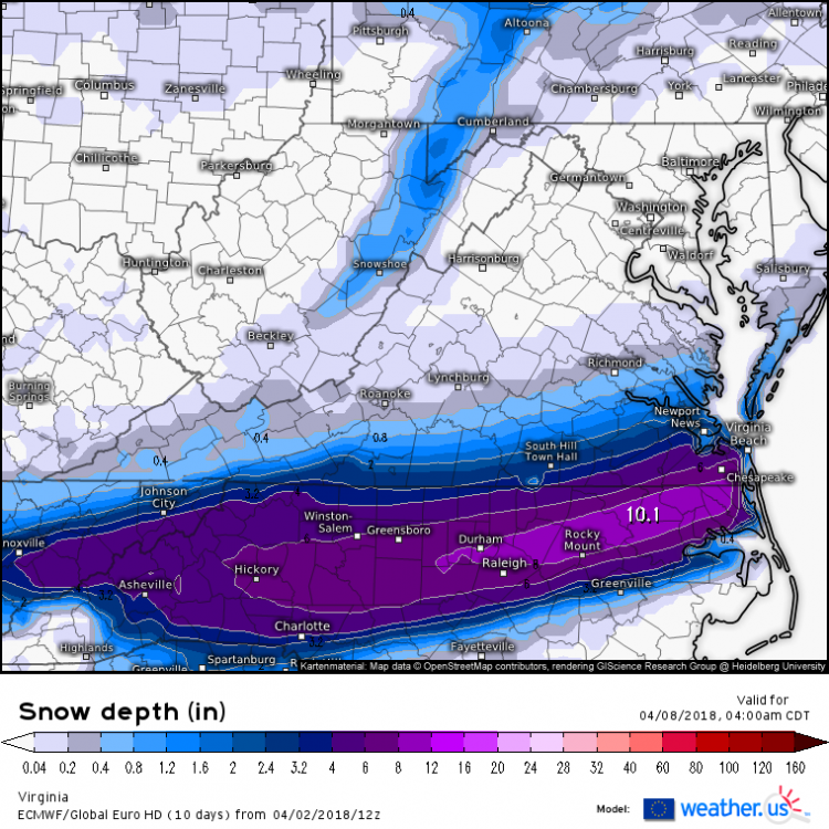
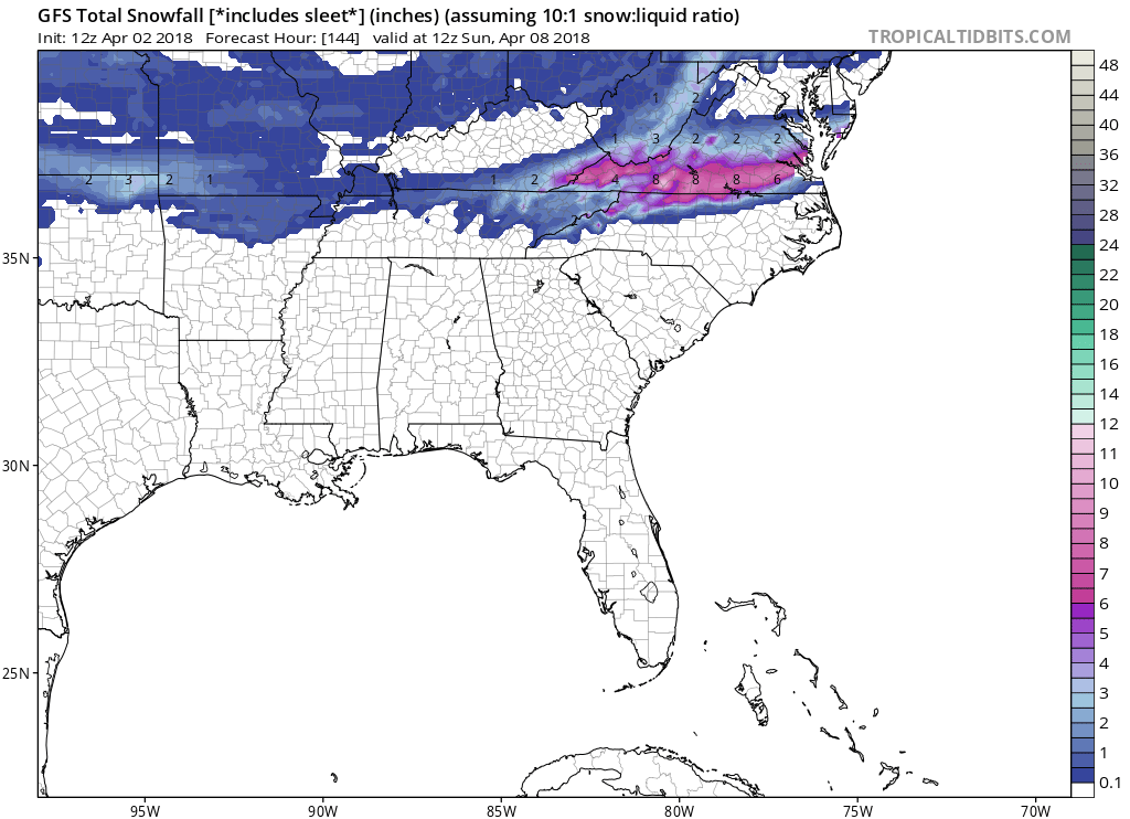
Here are the clown maps from today's 12z GFS and Euro. Amounts likely overdone, but the threat seems legit.