

BornAgain13
-
Posts
4,464 -
Joined
-
Last visited
Content Type
Profiles
Blogs
Forums
American Weather
Media Demo
Store
Gallery
Everything posted by BornAgain13
-

The “I bring the mojo” Jan 30-Feb 1 potential winter storm
BornAgain13 replied to lilj4425's topic in Southeastern States
But its a step in the right direction from 12z. -
The “I bring the mojo” Jan 30-Feb 1 potential winter storm
BornAgain13 replied to lilj4425's topic in Southeastern States
18z ICON looks good! Hopefully GFS keeps coming back this way -
The “I bring the mojo” Jan 30-Feb 1 potential winter storm
BornAgain13 replied to lilj4425's topic in Southeastern States
Pic? -
The “I bring the mojo” Jan 30-Feb 1 potential winter storm
BornAgain13 replied to lilj4425's topic in Southeastern States
Model waffles will continue for the next couple of days before honing in on a scenario. -
The “I bring the mojo” Jan 30-Feb 1 potential winter storm
BornAgain13 replied to lilj4425's topic in Southeastern States
EPS/GEFS/UK Ensemble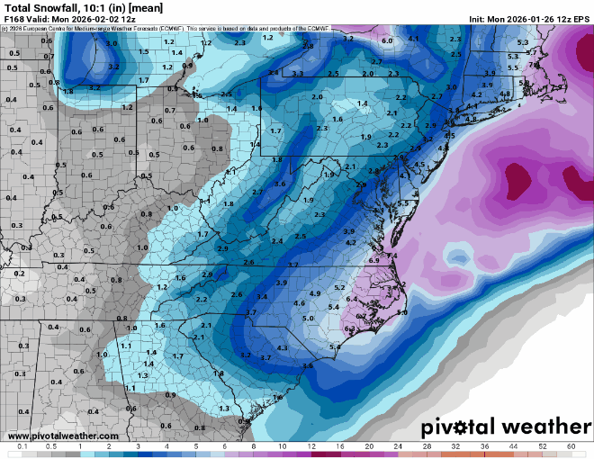
-
The “I bring the mojo” Jan 30-Feb 1 potential winter storm
BornAgain13 replied to lilj4425's topic in Southeastern States
12z EPS did follow the OP and go more east but it's still in a good spot this far out! Still a great signal!.thumb.png.e991cc6bbc941887863ab893c59fce44.png)
-
The “I bring the mojo” Jan 30-Feb 1 potential winter storm
BornAgain13 replied to lilj4425's topic in Southeastern States
Totals were still big for NC but not further north. -
The “I bring the mojo” Jan 30-Feb 1 potential winter storm
BornAgain13 replied to lilj4425's topic in Southeastern States
Just 1 run but central and eastern NC do really good!.thumb.png.c4f43c258f4af7137499a3deca534796.png)
-
The “I bring the mojo” Jan 30-Feb 1 potential winter storm
BornAgain13 replied to lilj4425's topic in Southeastern States
Yes! Its not far off -
The “I bring the mojo” Jan 30-Feb 1 potential winter storm
BornAgain13 replied to lilj4425's topic in Southeastern States
12z CMC Ensemble with a big jump west compared to 0z -
The “I bring the mojo” Jan 30-Feb 1 potential winter storm
BornAgain13 replied to lilj4425's topic in Southeastern States
12z EURO is east. Has some light snow but nothing like 6z. -
The “I bring the mojo” Jan 30-Feb 1 potential winter storm
BornAgain13 replied to lilj4425's topic in Southeastern States
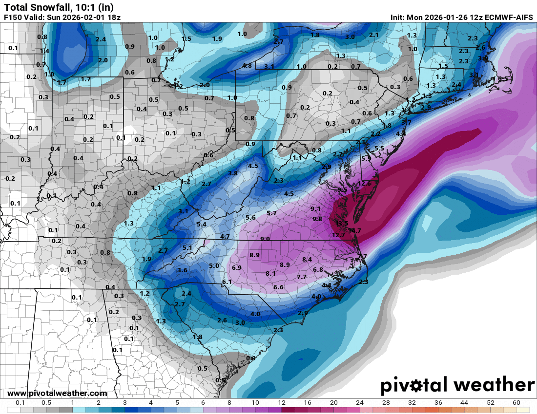
Euro AI is a tick east but still a big hit. These are just 10:1. These totals would be much higher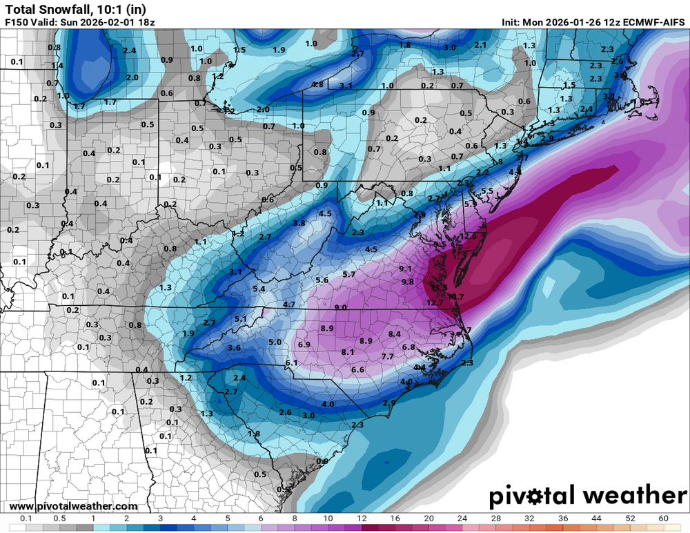
-
The “I bring the mojo” Jan 30-Feb 1 potential winter storm
BornAgain13 replied to lilj4425's topic in Southeastern States
.thumb.png.a3f09d9f41aacf364f6bd44622c7932c.png)
-
The “I bring the mojo” Jan 30-Feb 1 potential winter storm
BornAgain13 replied to lilj4425's topic in Southeastern States
12z GEFS is solid and better than the OP -
The “I bring the mojo” Jan 30-Feb 1 potential winter storm
BornAgain13 replied to lilj4425's topic in Southeastern States
UK is a moderate storm for some. But it gets in their late. -
The “I bring the mojo” Jan 30-Feb 1 potential winter storm
BornAgain13 replied to lilj4425's topic in Southeastern States
CMC agrees with Euro! Monster hit! -
The “I bring the mojo” Jan 30-Feb 1 potential winter storm
BornAgain13 replied to lilj4425's topic in Southeastern States
12z GFS is for Eastern NC but just a small adjustment and its a big dog -
The “I bring the mojo” Jan 30-Feb 1 potential winter storm
BornAgain13 replied to lilj4425's topic in Southeastern States
That is still possible! 5 days out. -
The “I bring the mojo” Jan 30-Feb 1 potential winter storm
BornAgain13 replied to lilj4425's topic in Southeastern States
Blend of Models Trend for the Potential Storm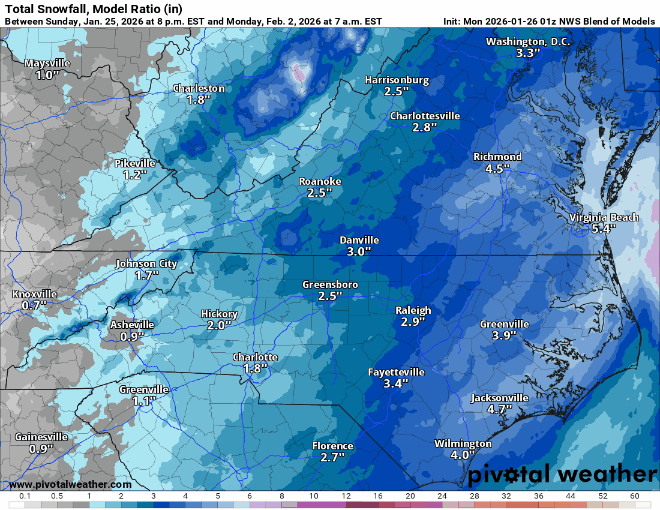
-
The “I bring the mojo” Jan 30-Feb 1 potential winter storm
BornAgain13 replied to lilj4425's topic in Southeastern States
Look at the temps while its snowing. Temps in the 10s and pouring Snow. -
The “I bring the mojo” Jan 30-Feb 1 potential winter storm
BornAgain13 replied to lilj4425's topic in Southeastern States
.thumb.png.96e310dca2b86a40ce9ee2fd90dde853.png)
-
The “I bring the mojo” Jan 30-Feb 1 potential winter storm
BornAgain13 replied to lilj4425's topic in Southeastern States
12z ICON big run -
The “I bring the mojo” Jan 30-Feb 1 potential winter storm
BornAgain13 replied to lilj4425's topic in Southeastern States
Please do stick around! -
The “I bring the mojo” Jan 30-Feb 1 potential winter storm
BornAgain13 replied to lilj4425's topic in Southeastern States
I dont. I got it off the mid Atlantic forum. My location is kinda in both lol. Im in the most upper part of the SE but in the lowest part of the mid Atlantic -
The “I bring the mojo” Jan 30-Feb 1 potential winter storm
BornAgain13 replied to lilj4425's topic in Southeastern States
Euro AI Ensemble Mean is a big hit and this is only 10:1. Ratios would be much higher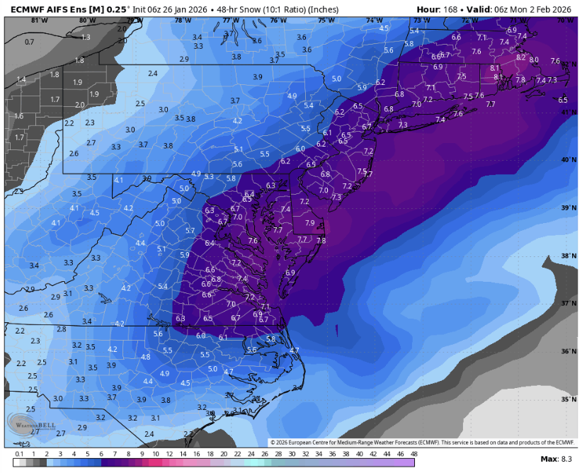

.png.f078a474952cd6754a08b35ba570df91.png)
.png.755fbaa151116ee8a821c03948b1bc4b.png)

.png.d98a1549de722c0ce7d8b34f736990ec.png)
.png.355768d4b8776ab583b85b95cd8f0363.png)

