

Frog Town
-
Posts
970 -
Joined
-
Last visited
Content Type
Profiles
Blogs
Forums
American Weather
Media Demo
Store
Gallery
Posts posted by Frog Town
-
-
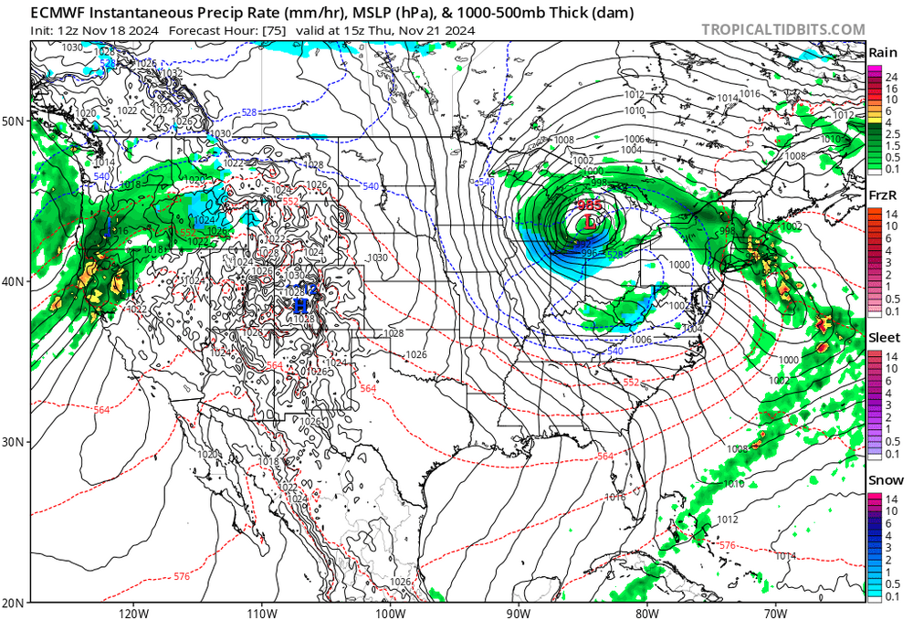
Not often you see a dry slot and warm tongue with this orientation!!
-
 2
2
-
-
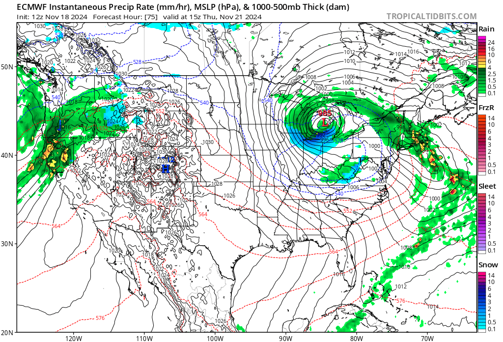
It's back and 12Z was a juicy run.
-
3
-
 2
2
-
-
0Z and 12Z Euro's are almost carbon copy's, weird.
-
7 minutes ago, nwohweather said:
The Euro maps are just wild. 8-16" for NW Ohio
Must be the new upgrade! I'll take it.
-
 1
1
-
-
4 hours ago, SolidIcewx said:
I want whatever drink the GFS is having
More like whatever drug the GFS is on. 11 days out...lock it in.
-
1 hour ago, michsnowfreak said:
That November was one of the warmest on record....then we had a snowstorm on Thanksgiving.
If I'm not mistaken, the following Winter was epic, I believe. I know 76'-77' was one of the coldest, but I can't remember is 75'-76' was as cold.
-
2 hours ago, DocATL said:
Agree with you…currently not a warm
Phase though we are decently above normal. Headed to warmer phases mid month.
.Hmmm, so logically, if we are in a cool phase but warm, then we will cool when we head into a warm phase. Sounds pretty straight forward.
In all seriousness though, a few years back, maybe 2019-20 or '18/'19, all the local Mets sounded the alarm that things were lining up for a very cold and snowy Winter. I think it was end of November/early December which is a pretty safe time to make a Winter call. I've never seen Toledo Mets put it all on the line like this and it was pretty unanimous. Which ever winter it was, it ended being a bust. All this to say, I'm not overly concerned with the warm signals we are getting. If anything, it brings comfort knowing that I won't be disappointed.
-
16 hours ago, DocATL said:
https://x.com/bamwxcom/status/1847600138174317053?s=46&t=vaNz3X96rQKSXMNwtdXFsA
lol…November forecast. Is this a joke?
Literally no model shows this.
.Looking at the pacific currently, November is gonna be chilly. Almost a complete replication of November 2013. Not saying it's gonna stick like 2013-2014, but that sure would be nice.
-
I know it's early but it's hard to ignore how similar the pacific is currently, along with the recurving typhoons, to the fall of 2013....Just sayin.
-
1
-
-
It's starting to get very frustrating as we enter another neutral ENSO during the wrong time of the year. Here in the Midwest we've had a cooler than normal Summer only for it to flip during the fall/Winter and average above average with La Nina. It's been since the 2013-2014 that this has been the case. Here's your shitty Winter Forecast, early and for free.
-
~2" here in Toledo..so far
-
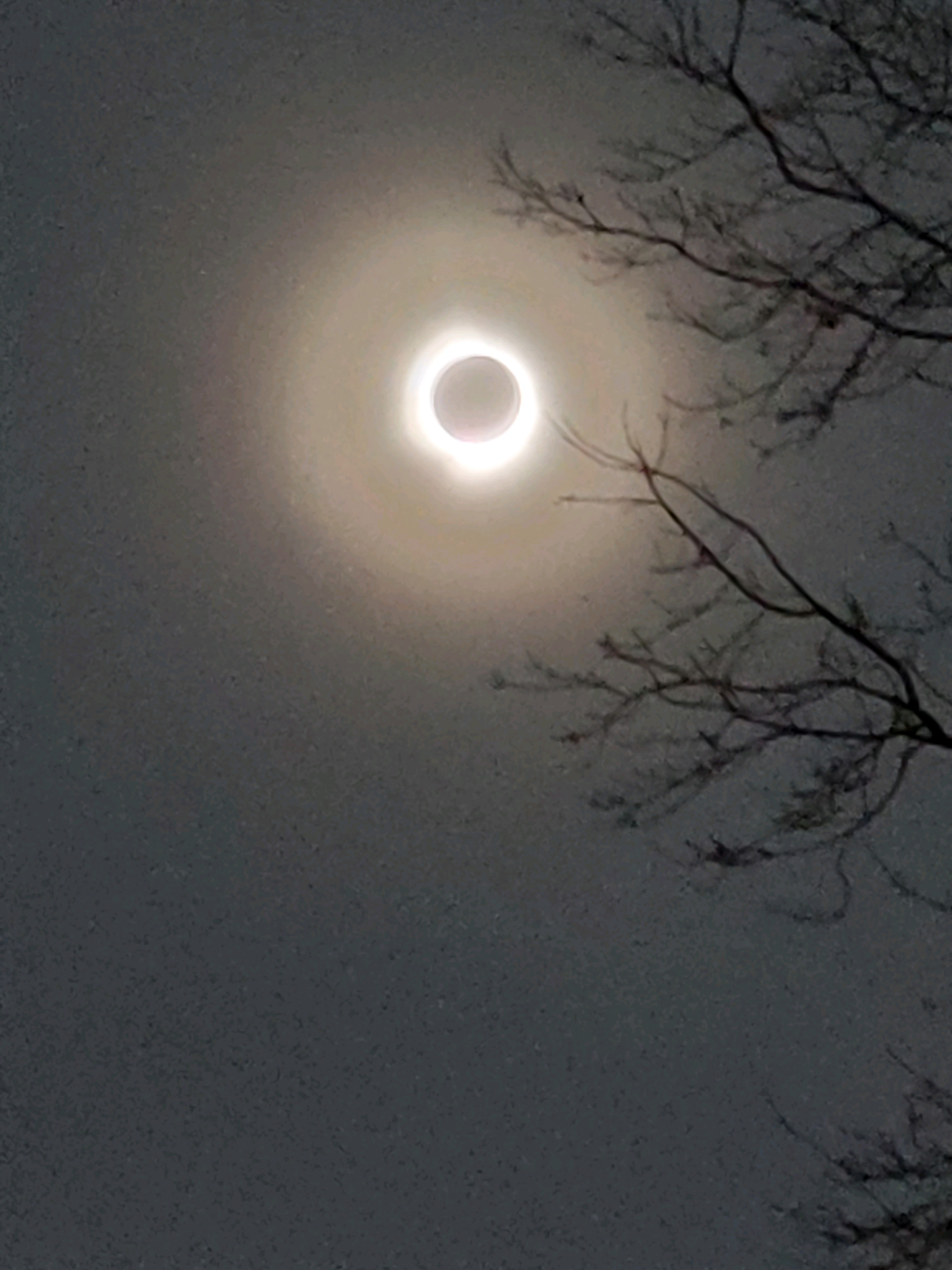
13 minutes ago, buckeye said:
Totally lucked out. Blue sky with some wispy cirrus Had 45 seconds of total where you could look without glasses. It sounds obvious but it got much darker than I expected probably because I had only seen partial eclipses in the past and always expected those to be darker. Crickets started chirping street lights came on and you could hear people cheering in the distance. Bucket list checked without having to leave my yard.

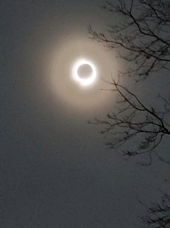
Same! Really indescribable and surreal.
-
16 hours ago, michsnowfreak said:
While I'm sure they won't get that much, there's definitely a significant signal for snow in the northern part of the country the last half of March. This is why I always say to those talking futility in January or even earlier that the snow season has so long to go, you really have to have EVERYTHING go wrong to get that. I can't think of a more deserving season than this one for the Northwoods, but mother nature may have other plans. Duluth still in the running, but Minneapolis screwed that up by being in the jackpot of that February snowfall. Here in Detroit, I cannot remember a more benign winter outside of one month, but since that 1 month produced 17 inches of snow, again, top 10 futility off the table. Toledo is surprisingly still in the running for their 2nd least snowy winter.
Yup
-
Storms and Cold back on the docket for the last week in March with potential big dog stuff. Curious if it will stick, or just smoke and mirrors...
-
I remember reading and researching climate change/global warming as a kid. The one thing that has stuck with me was the talk of drastic/wild temperature swings much like we are seeing. Is it really even a debate anymore?? I think the wild extremists that talked of oceans rising 10ft and ridiculous temps muddled the waters and created a bunch of skeptics and conspiracy theorists. Which are now grown adults with very loud Social Media speakers..
Probably the wrong thread but Winter's is over for the foreseeable future.
-
1
-
-
4 hours ago, michsnowfreak said:
1882, 1976, 2017 are other impressive late Feb warmspells.
Was it late '16 or '17 that had the late Feb really warm spell. I thought it was '16
-
7 hours ago, Snowstorms said:
Yeah would be quite historic too. But the way this winter has gone, I wouldn't be surprised if we saw a warm March like 2010 or 2012.
Late February is looking very late '98ish, another very strong Nino year.
-
Quick and efficient transfer I guess. Does seem kind of odd as that is our bench mark..
-
Considering starting a thread...JK. But this would be amazing.
-
2 hours ago, hawkeye_wx said:
For the second consecutive day, a stratus deck advecting in from the east killed our temp, holding us in the mid 30s. The east wind off the lakes can be a real downer in winter and spring.
Same
-
See you guys mid Fall 2024. Been real but now I gotta focus on my taxes and other less interesting things.

-
2
-
1
-
-
That HUGE ridge that try's to torch the middle of the country first week of FEB get's crushed by what looks like a west based -NAO forming. Kind of weird set up but seems to suppress everything south but no much cold air to work with.
-
2 hours ago, SchaumburgStormer said:
Didn't they have an obscene snow depth last year?
I traversed Mt. Whitney in the Sierra Nevada last August and we were dealing with a ton of left over snow from the previous event the Sierra Nevada last winter. A lot of the locals had some crazy stories of being buried for days.
-
1 hour ago, OHweather said:
Any chance you were out and about this morning there? I was also worried in the evening when I saw the warm surface temps, but I saw a lot of schools closed and I saw some reports of very icy conditions. Curious to hear how bad it actually was or wasn’t. TOL never got below 34 degrees
Sure enough surface temps of 30-31 did us all in. Glazed up everywhere and was an easy call with schools this morning. Just so different than the normal ice storm set-up(NE dry feed, 3M temps below freezing, etc.) Really made me second guess the eventual outcome. Thanks for chiming in though.
-
 1
1
-

Fall 2024 Medium/Long Range Discussion
in Lakes/Ohio Valley
Posted
Pattern looks pretty sweet for the OV late next week. Always worry about too much suppression in these set ups, but not sure about the SE Ridge flexing in these set ups. Would love to see a spread the wealth system but it's a weird time of year to get something like that..