

Frog Town
-
Posts
833 -
Joined
-
Last visited
Content Type
Profiles
Blogs
Forums
American Weather
Media Demo
Store
Gallery
Posts posted by Frog Town
-
-
I've been home from school(I'm a teacher) now for 2 days and I'm bored. We haven't had one of these for a while and a few models are hinting at some phasing forming a SLP over WV. This could add some enhancement throwing a bone to snow starved portions of the sub. Let's go! Pretty consistent message coming from the hi-res stuff.
-
 1
1
-
-
1 hour ago, mimillman said:
Riding the RGEM
You and me both!
-
Nice baroclinicity setting up across the region could give a long duration event over the next few days. May even reach low end advisory criteria. True arctic stuff.
-
2 hours ago, OHweather said:
To be fair, I hit send on this a little earlier than these posts:
URGENT - WINTER WEATHER MESSAGE
National Weather Service Cleveland OH
248 PM EST Fri Jan 12 2024

OHZ003-130000-
/O.NEW.KCLE.WW.Y.0002.240112T1948Z-240113T0000Z/
Lucas-
Including the city of Toledo
248 PM EST Fri Jan 12 2024

...WINTER WEATHER ADVISORY IN EFFECT UNTIL 7 PM EST THIS
EVENING...

* WHAT...Wet snow occurring. Additional snow accumulations of up
  to two inches.

* WHERE...Lucas county.

* WHEN...Until 7 PM EST this evening.

* IMPACTS...Plan on slippery road conditions.

* ADDITIONAL DETAILS...Heavy wet snow will impact travel
  conditions through the evening commute.
We were aware of the potential for an impactful burst of wet snow in the Toledo area, but yes the advisory came out later than would've been preferable. I had a bit of a gut feeling around 1 PM when TOL immediately dropped to 3/4 mile visibility in snow when precip came in...but since it was still 36-38 degrees across Lucas County, raining in Wood County south of the turnpike, and only sticking to grass in western Lucas County (not in the city of Toledo) I wasn't sure if it'd snow long enough to accumulate 2"+. I have no problem issuing an advisory for less than 4" of snow (our technical advisory criteria) based on impact, but there has to be a line somewhere and I don't want to do an advisory if I'm not confident it'll snow at least a couple inches. We issued a Special Wx Statement for up to 2" of quick snow accumulation and slick road conditions around 1:20. By 2:30 Findlay flipped to snow, precip rates were intensifying, and snow was sticking to roads in Lucas County. It was obvious that conditions would be poor through the evening commute and also that snow accumulations would be a good couple/few inches in western Lucas County, so we went with the advisory at that point.
Of course my friend. I have a ton of respect for you guys in a very unforgiving and difficult craft. I was probably too excited to notice the time stamp.
-
Fighting MJO warm phases.
-
Maybe Stebo can help out but it looks like dry slot of over in INDY is filling in and next wave may stay snow here. I'm I looking at the radar right? If that stays all snow, then we are in business.
-
31.8 here in Toledo with Heavy Snow and 2.5". Actually 10 miles NW of Toledo.
-
WWA posted for Toledo. A little late to the party
-
 1
1
-
-
Crazy snow if Toledo with 2" already. Does anyone really know what's going on?? LOL>
-
NAM definitely an improvement for SE MI. Low seams about 50 miles to the east once it enters MI
-
1
-
-
So it begin...
-
 1
1
-
-
2 minutes ago, Lightning said:
I have not heard of Toledo or Monroe ever getting a big east wind LES event. I know it is possible and probably has happened. At MTU (Houghton) a couple of my best LES events were E/ENE winds off Superior but they were not common to get at all.
I experienced a freak lake event in Toledo in the early 90's. Weirdist thing I've ever experienced and remember looking at the radar in disbelief. Don't remember the set up but it's the only time i've experienced it in my life time.
-
1
-
-
1 minute ago, Radtechwxman said:
I like your optimism but I'm highly skeptical unfortunately
I was only kidding. I'm still in the bargaining stage of my grief.
-
3
-
-
42 minutes ago, A-L-E-K said:
0z nam will be a chicago crusher, u can tell
I think the 0z Euro will be the beginning of a SE trend, u can also feel it in the air..
-
1
-
-
If we can get this to keep trending NW, we could get a secondary low development towards the OV....That would be hilarious.
-
1 hour ago, HillsdaleMIWeather said:
riding the canadian
All the way, neighbor! -
Even up here in Toledo things suck.
-
2 minutes ago, A-L-E-K said:
where is south, flat, weaker when u need it
Warm December still haunts us...Damn
-
2 hours ago, HillsdaleMIWeather said:
We appreciate your input, please dont stop posting
You're just being to practical Stebo! We got ya!
-
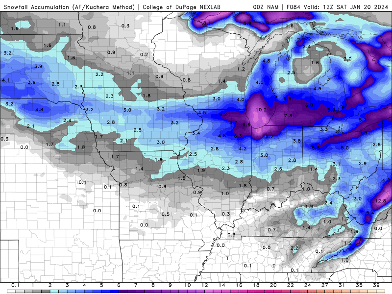
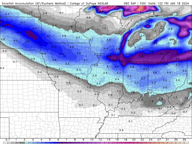
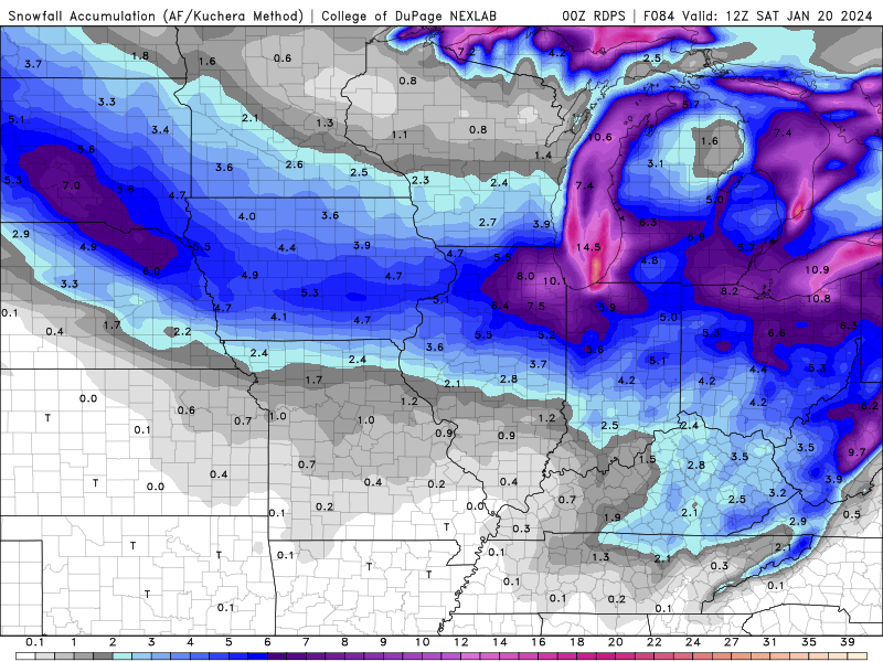
12 minutes ago, CheeselandSkies said:
Not bad consistency on placement and intensity 36 hours apart:


Actually supports why it's unlikely. Think what these don't have in common. Orientation and trajectory of Huge Arctic High to the north...
-
41 minutes ago, Stevo6899 said:
Even sexier on the rgem, however it was SE with this current storm at this range so who knows at this point. Ukie/euro way nw.
Also the deformation snows look to be very tight and close to the low which hopefully will keep the dry slot away, that the euro/ukie show.
Kind of resembles a Hurricane with that eye structure LOL.
-
Hopefully we get a couple three weeks of this and it doesn't disappear as quickly as it came.
-
Anyone else finding themselves over stimulated at the moment?? We went from zzzzz to
 world in like 4 days LOL.
-
4
-
2
-
-
Just now, michsnowfreak said:
Exactly lol. That is our classic snowstorm track.
I think it depends on the antecedent air mass in front which can offer multiple outcomes to the same track..


Did Someone Say Clipper(Hybrid)!?! 1/18-1/19
in Lakes/Ohio Valley
Posted
Rookie error on my part. Was kind of hoping we could keep it going between the two, but that's wishful thinking.