

Frog Town
-
Posts
833 -
Joined
-
Last visited
Content Type
Profiles
Blogs
Forums
American Weather
Media Demo
Store
Gallery
Posts posted by Frog Town
-
-
6 minutes ago, OrdIowPitMsp said:
Overnight low of 70. Lawns are starting to turn brown.
Didn't your snow just melt off??
-
2 hours ago, josh_4184 said:
LOL, i am assuming this is overdone or at least hoping.
Not sure...
Nice cut off in early May. Did we even have anything like this all winter, lol.
-
 1
1
-
-
23 hours ago, nwohweather said:
Not much can beat April 2016 though. To see 7” of snow was truly shocking
That was the first time we went sledding that Winter....if you could even call it a winter.
-
 1
1
-
-
Closing in on 4" here just NW of Toledo. Coming down nicely with 1-2 more to go.
-
2
-
-
3 hours ago, nwohweather said:
Still like the 3-6" for Toledo, should be an absolutely terrible commute tomorrow morning. I do think CLE needs to be chided a bit for only issuing a WWA for Toledo, there's no reason all counties north of US 6 are not under an advisory until you get east of Sandusky
.NEAR TERM /THROUGH FRIDAY/... 12:30 PM Update... Am working on final grid edits and headline coordination regarding the snow arriving late tonight into Friday morning. Will be hoisting additional advisories for the rest of NW PA and the northernmost 1-2 tiers of counties in OH over the next 1-2 hours. More detailed discussion will come later this afternoon. -
6 minutes ago, michsnowfreak said:
DTX calling for 11-13:1 ratios.
Night snow fall is making the difference.
-
3
-
-
3 minutes ago, Chinook said:
I may finally have to shovel more snow than I did in January.
Hey Toledo friend! Are you seeing some 12Z data that favors our area, finally??
-
In the middle of the sub the NAM trends N and the Euro trends S.
-
It's kind of weird as we haven't had a SLP take this trajectory across the sub yet. Curious how the models will handle this Bowling Ball type Low.
-
1
-
-
Wagons south...and it's not done.
-
2 hours ago, Malacka11 said:
We gonna make a thread for the 9th-10th or...
Are you banned from starting threads??
Smells like an OTIS bomb to me..
-
34 in Toledo with a dew pt of 31ish...
Rain/snow mix but temp is coming down to the dew point. We are right on the line of who knows what..
-
24 minutes ago, Baum said:
.thumb.png.f5cb2841386ee07e4f97b29acdf32011.png)
Just wait...
-
On 2/27/2023 at 5:53 PM, Frog Town said:
It'll be back to it's Sunday solutions by 12Z Wednesday.
Got lots of laughs when posted but now it's not so funny. When you've seen this happen so many times over the Winter, it doesn't take a MET degree to catch on.
-
1
-
1
-
-
25 minutes ago, Stebo said:
The 18z Euro is a bit NW of the 12z at the same time. A pretty large zone of ice with it too.
Nice to have you back, Stebo. Always appreciate your insight and tactfulness.
-
1
-
-
It'll be back to it's Sunday solutions by 12Z Wednesday.
-
2
-
2
-
-
39 minutes ago, RCNYILWX said:
Glad to be a part of the discussion
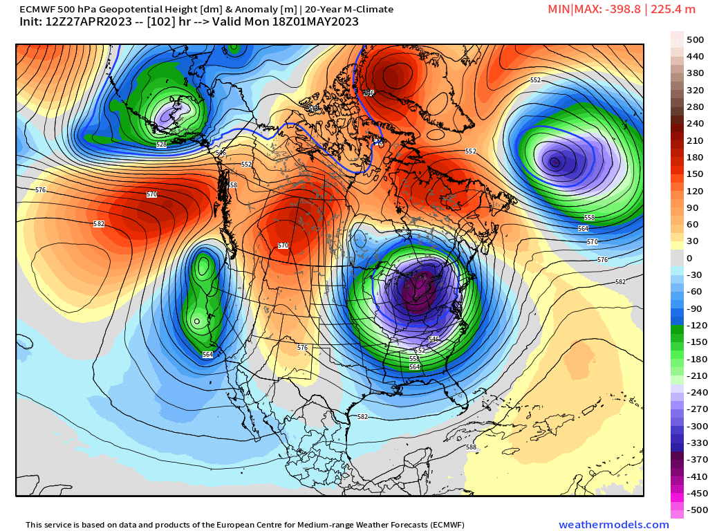
Here's some items I've noted:
- Anomalously deep surface low for a relatively far south latitude is pretty much a lock with the plotted EPS members all stronger than the 982 mb mean on the IL/IN border at 18z Friday
- Bowling ball nature of the 500 mb low supports the idea that the track can be unusually far south for a system of this nature, in the presence of a strong downstream -NAO block. Another late season example of this was the late March 2013 snowstorm that brought record snow to SPI.
- The downstream -NAO block is the key to the setup of here and points south still being in the game.
- The general idea or trend of 12z suite today of deeper and farther north track also makes sense given the very strong and dynamic 500 mb low/PV anomaly, which can be expected to help pump downstream heights in the northeast a bit.
If you look at 500 mb height anomalies, there's positive east of here and negative over Canadian Maritimes trapped under the block, and that'll be the impetus for our primary bowling ball wave to track east northeast and weaken instead of a sharper northeast or north-northeastward track.
The presence of the NAO block merely gives us a chance that things could work out. It's a delicate balance with respect to the strength of the synoptic system and "feeling" the downstream block. The warmer and farther north solutions on the EPS and the GFS/GEFS are on the table, though I do think there's only so far north it can go.
I'm concerned about a miss just north for us with the heavy snow swath because there will be a tremendous amount of latent heat release to help height rises east of here, and that may overcome downstream blocking to an extent, especially if the block trends a bit weaker.
Edit: With 12z EPS 500 mb heights and anomalies valid 12z Friday.
You are awesome for sharing your craft with us in a way that is priceless to wienies like us. Thank you!
-
3
-
-
We are all suckers!
-
1
-
-
6 minutes ago, Stevo6899 said:
The only thing that can save this winter is a nw trend to a 2 footer. Automatic winter grade of b if that happens.
Bribing the weather Gods I see..
-
1
-
1
-
-
I never do this but.....That's me in the green.


-
1
-
3
-
-
Pretty nice looking but it's an outlier at this point despite the nice ensemble look.
-
I hope it's wrong as this is about the time i'm looking forward to things warming up. Darn Murph!
-
 1
1
-
-
I work in Lenawee County Michigan and everything is shut down.
-
1
-
-
Nice lightning and thunder during our ice storm now. What's next??
-
2
-
.png.9c8abed2cdac250c5fc8102c1c3ee196.png)
September 2023 General Discussion
in Lakes/Ohio Valley
Posted
No Winter thread yet but I'll just place this right here......very interesting.
https://www.severe-weather.eu/long-range-2/winter-2023-2024-forecast-polar-vortex-el-nino-qbo-strong-impact-cold-weather-united-states-canada-europe-fa/