

Frog Town
-
Posts
833 -
Joined
-
Last visited
Content Type
Profiles
Blogs
Forums
American Weather
Media Demo
Store
Gallery
Posts posted by Frog Town
-
-
unfortunately this is where we were with this Tuesday's storm and look how that turned out for Southern Michigan. Wait till Thursday night.
-
 2
2
-
-
Curious if these NW trends are a result of a classic set up of cold(with the PV position) and that it's foreshadowing the rest of the Winter.
-
Man! The 12Z G-spot was a cold run as well. Great follow up to a giant spread the wealth pattern.
-
3 minutes ago, HillsdaleMIWeather said:
Chicago folks reeling this one in unless stuff suddenly changes tomorrow or Sunday
It'll come back home.
-
 4
4
-
-
3 hours ago, mississaugasnow said:
January 2016 seems similar at Toronto where it looks like we got heavy rain followed by cold, brief warm up, 1.5" of snow and then below freezing for a week but nothing crazy cold. Will be interesting to see if it follows the same script
Depending on if this whole polar vortex thing is a tease, which happened often during the 2015/2016 Winter, then it really is following that winter.
-
13 minutes ago, SchaumburgStormer said:
I have a 2 year old who has yet to go sledding due to the lack of snow the past couple seasons. She is old enough to keep up with her big siblings now, so hoping to be buried (mostly so I can send their asses outside and get some peace and quiet, lol).
Amen to that and my four little ones!
-
2
-
-
Wow! Grand Rapids in taking this seriously...
-- Increased chances for impactful mid-week winter storm --

Confidence is growing that there will be a winter storm either
directly impacting or in the vicinity of Lower Michigan. In fact,
ensemble guidance has begun to converge on a solution that, should
it occur, would be reminiscent of our recent December 22, 2022
blizzard. This would mean widespread snow accumulations well over 6
inches, followed by lake effect snow along with very strong
northwest winds that could produce blizzard-like conditions
Wednesday morning. However, precipitation type is far from certain;
a significant rain component remains possible and this could
significantly curtail snow accumulations.

While what`s described above is far from certain at this point, I
still feel it is worth mentioning now as a possibility for the
following reasons:

1) It is not too early to be thinking about contingency plans for
possible travel and power disruptions next week.

2) There has been a signal for a major pattern shift starting nearly
a week ago. This has consistently featured a deep, strongly phased
western U.S. trough resulting in surface cyclogenesis in the lee of
southern Rockies. These have a strong climatological propensity to
track northeast towards the Ohio Valley, often while deepening.

3) Past storms in recent memory exhibiting this pattern showed
remarkable predictability and consistency in model guidance leading
right up to the event. This presumably has much to do with inherent
predictability associated with deep longwave troughs such as the one
we`re dealing with now.

4) Ensemble solutions, particularly the ECWMF Ensemble (ECE),
indicate potential for explosive cyclogenesis as the surface low
tracks toward the Ohio Valley. The ECE mean MSLP has dropped to 980
mb, which would imply that several ensemble member solutions feature
minimum pressures significantly less than that. Not surprisingly, we
are now seeing Shift of Tails (SoT) values in the ECE approaching 2
or greater over parts of Lower Michigan. This means that there are
several ensemble member solutions behaving as extreme outliers
relative to ECE model climatology. This also emphasizes strong
positional sensitivity to the forecast when dealing with what could
be a very deep surface low setting up somewhere.

While it`s easy to focus on what snow occurs (which undoubtedly
could be especially jarring given the winter that we`ve had so far),
we are just as concerned about the wind threat that may manifest on
the back side of the exiting, deepening low. The official forecast
will continue to smear wind speeds downward due to averaging of
model solutions, but it should be noted that we could in fact
experience very significant northwest winds and gusts that may
impact much of Lower Michigan sometime in the middle of the coming
week.
-
3
-
-
Curious if the Polar Vortex split pushes everything SE a bit?? It happened back in 13-14 a few times, although the PV orientation is different this time.
-
I'm not gonna watch any models until 12Z Monday.....Not! Kind of enjoying the emotional rollercoaster, LOL. Also looks good down the road so we could be looking at snow on snow, which we have not had in a long time.
-
1
-
-
29 minutes ago, Baum said:
posting BAN weather takes is bold. You've been a burr in the saddle for eons. I'd say posting this shit in this forum after 2 years of snow and cold drought when we're finally seeing something good is going to bring out the torches and pitchforks crowd. I'm all for it.
.jpeg.919f0260d0da8f3e73de1d7bb958ca7a.jpeg)
You and I have been on this forum for years and seen our share of a-holes. These post are not of ill intent and far from what we've seen before, plus on topic. It's a weather forum and we are all pretty much nerds(Never, Ending, Radical, Dudes) so just relax a bit.

-
 3
3
-
-
This weekend's Nor'easter did trend weaker and SE. Seems to be following last year's trends.
-
12Z EPS SLP track is text book for the NW half of the sub with a track from Cinci to CLE.
-
30 minutes ago, Malacka11 said:
Alek how about you start the thread when we get to that point
I figured it'd be between him and HandPalmGuy, or whatever his name is LOL.
-
2
-
-
5 hours ago, dmc76 said:
Ll
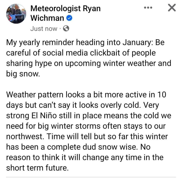
This is not a recent post from Ryan Wichman as I know him personally and he has not made this post recently. Must be really old or from a different account.
-
1
-
-
12 minutes ago, STILL N OF PIKE said:
Anyway , I was surprised to see how poorly Mammoth Mountain was doing .
26” inches to date . I imagine they have extreme variation from month to month and year to year but I was curious if anyone in the lower 48 had a decent December .
Maybe Jackson Hole? (edit yup 125” summit / 76” mid mountain ) they average upper 400’s up top
I've summited both the Tetons and Mt. Whitney in the past year. I was shocked at how much snow was at the top of Mt. Whitney this past August. Almost couldn't make it to the top. Middle Teton not so much.
-
2
-
-
Truly epic! I couldn't start the track season until mid April due to the actual glacier draped across the track.
-
2
-
-
When I was trick-or-treating with my kids on Halloween and it was 32 and snowing, I joked with them and said, "Watch it be 60 and raining on Christmas"......
-
1
-
2
-
 1
1
-
-
1 hour ago, Chambana said:
Keeping expectations low during a borderline very strong El Niño keeps your sanity. So anything noteworthy that does pop up is a welcome surprise. This winter has been playing like out strikingly similar to 2015-16 so far.
My thoughts exactly. Our first accumulating snow fall that year was during spring break...
We actually went sledding but the 8" melted off by noon.
-
1
-
-
11 minutes ago, hardypalmguy said:
Tick tock, tick tock. Palms are more likely to survive than snowbanks this year.

Dude! I'm sure you're a good guy but this is how I picture you......Annoying the piss out of everyone.

-
2
-
 1
1
-
9
-
-
Thanks for the feedback. This Winter just seems to resonate similar to that Winter so far, but I hope that changes.
-
If my memory serves me correctly, wasn't 2015-16 a Winter where the cold was always two weeks away but ended up staying on the other side of globe all winter?? I also remember a constant modeled SSWE that always threatened but never really materialized. Am I getting the right Winter??
This one is starting to feel a lot like that one...
-
3 minutes ago, michsnowfreak said:
My thing is, it's just so early. if it was late February and you were staring down futility, I could understand the sentiment (lol but the snow lover in me would not agree, I'd wish for a 1983 spring snowstorm to happen). Detroit's current 30 year average snowfall is 45.0" (which is actually the highest 30 year average on record due to all those good times and the 2000s-10s), and avg to date is 5.5". Which means we have 88% of the snow season to come.
I love your optimism. Hoping for a turnaround in early January.
-
2
-
1
-
-
1 hour ago, RogueWaves said:
Rumblings of a colder (MJO) and snowier (LR GFSh*t) look from around Christmas and thru the holidays. Less Grinchy anyways.
I guess things always seem better when you've hit rock bottom.
-
3
-
-
28 minutes ago, Stebo said:
Should break the record of 58 here today, forecast high is 60.
Stebo, I've always respected your opinion and insight into the weather.
What are you thoughts on what the teleconnections are showing towards the end of December? I'm getting that feeling we are chasing a ghost as things continue to get pushed back.

Jan 11-13th Blizzard
in Lakes/Ohio Valley
Posted
I remember this storm. Arctic air raced across michigan during the storm and caused a rapic change over from heavy rain to crazy wind and snow. I stayed up all night for the transition and it was epic. Even had Lightning and thunder here in toledo.