

Hoosier
-
Posts
47,183 -
Joined
Content Type
Profiles
Blogs
Forums
American Weather
Media Demo
Store
Gallery
Everything posted by Hoosier
-

The August 21, 2017 Great American Eclipse
Hoosier replied to ice1972's topic in Weather Forecasting and Discussion
Agree, farther southeast should be better. Missouri is the real up for grabs area. -
The August 21, 2017 Great American Eclipse
Hoosier replied to ice1972's topic in Weather Forecasting and Discussion
Question is which way do the Nebraska people go, especially chasers in the eastern part of the state. Do they head west or try to get east in Missouri/Illinois? -
The August 21, 2017 Great American Eclipse
Hoosier replied to ice1972's topic in Weather Forecasting and Discussion
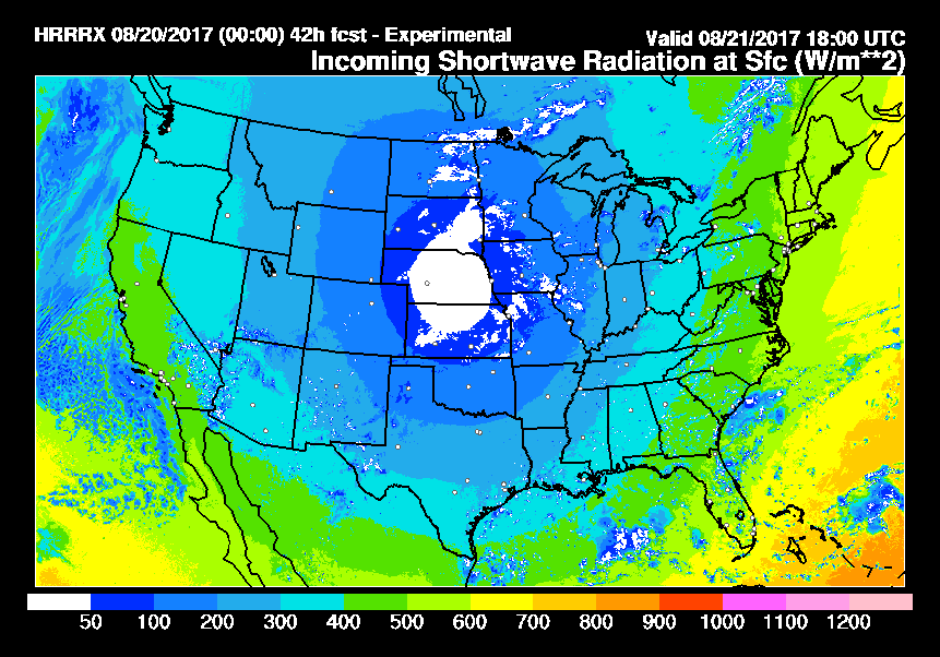
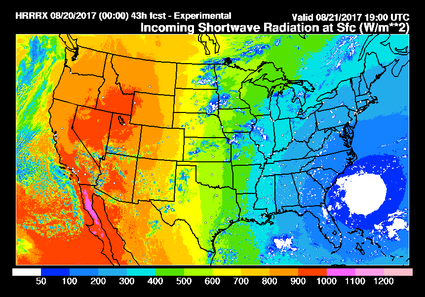
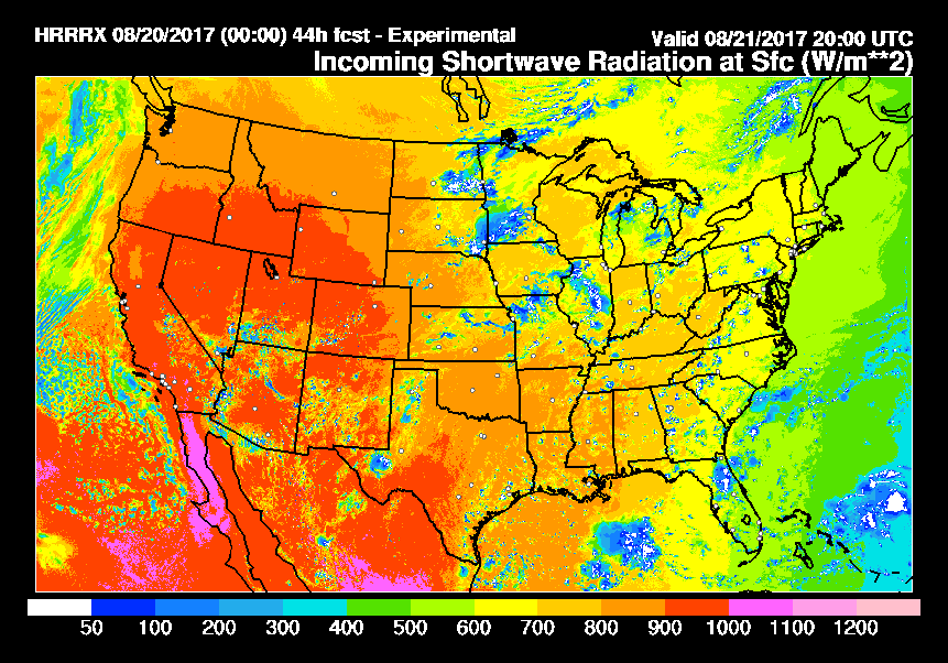
These maps are cool to watch the progression across the country. Huge decrease in the amount of incoming shortwave, even far outside the totality zone, followed by a big recovery.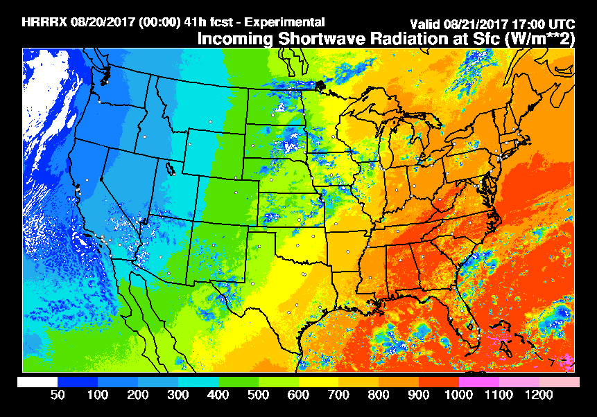
-
The August 21, 2017 Great American Eclipse
Hoosier replied to ice1972's topic in Weather Forecasting and Discussion
That experimental RAP does separate into low, middle, and high level clouds for anyone who is interested https://rapidrefresh.noaa.gov/RAP/ -
The August 21, 2017 Great American Eclipse
Hoosier replied to ice1972's topic in Weather Forecasting and Discussion
This is kinda cool... a look back at how some newspapers covered the last coast to coast eclipse in 1918. The Topeka State Journal headline in particular, which told people that the next chance for a similar eclipse wouldn't be until 2017. https://m.mic.com/articles/amp/183041/heres-how-newspapers-around-the-country-covered-the-1918-solar-eclipse -
The August 21, 2017 Great American Eclipse
Hoosier replied to ice1972's topic in Weather Forecasting and Discussion
St Louis afd seems more pessimistic. However they and Paducah mentioned how the models may be affected by not properly accounting for the reduced insolation. The HRRRx is supposed to be running with eclipse conditions so it will be interesting to see how it handles clouds/precip output around 18z Monday. -
The August 21, 2017 Great American Eclipse
Hoosier replied to ice1972's topic in Weather Forecasting and Discussion
It's 4+ minutes on the center line from eastern Indiana southwestward. Almost 4 1/2 minutes by the time you get to Texas. -
The August 21, 2017 Great American Eclipse
Hoosier replied to ice1972's topic in Weather Forecasting and Discussion
A little OT about the April 2024 total eclipse. If I did the proper research, it looks like that will be the longest duration total solar eclipse in the US since the June 16, 1806 total eclipse. A can't miss event, especially for anyone not able to get into the path of totality on Monday. -
The August 21, 2017 Great American Eclipse
Hoosier replied to ice1972's topic in Weather Forecasting and Discussion
I'd def be feeling more confident around BNA. -
The August 21, 2017 Great American Eclipse
Hoosier replied to ice1972's topic in Weather Forecasting and Discussion
I'm gonna have some degree of nervousness until I am viewing it. This isn't like missing a big snow where there's always some hope that the next one may come soon. We know we're not getting another shot at this for almost 7 years (at least in this country). -
The August 21, 2017 Great American Eclipse
Hoosier replied to ice1972's topic in Weather Forecasting and Discussion
I thought I saw somebody in one of the forums saying they will be in Oregon. But you'll at least be one of the first. Incredible to think of how fast the shadow travels... -
The August 21, 2017 Great American Eclipse
Hoosier replied to ice1972's topic in Weather Forecasting and Discussion
You can get these on regional views at TT -
The August 21, 2017 Great American Eclipse
Hoosier replied to ice1972's topic in Weather Forecasting and Discussion
Even farther east... like Sainte Genevieve. It's basically on the Illinois border and if I'm trying to outrun clouds moving in from the west, then I may try to get farther away and head for KY. -
The August 21, 2017 Great American Eclipse
Hoosier replied to ice1972's topic in Weather Forecasting and Discussion
Good luck. I am going to try to be as far east in Missouri as possible but if that doesn't look promising, then I should be flexible enough to get into southern IL or western KY. Just gonna try to stay away from Carbondale lol. I have abandoned any notion of trying to make the entire drive on Monday morning... that is just another stressor and I'd be kicking myself big time if traffic did me in. -
The August 21, 2017 Great American Eclipse
Hoosier replied to ice1972's topic in Weather Forecasting and Discussion
You doing Nebraska? -
The August 21, 2017 Great American Eclipse
Hoosier replied to ice1972's topic in Weather Forecasting and Discussion
-
The August 21, 2017 Great American Eclipse
Hoosier replied to ice1972's topic in Weather Forecasting and Discussion
I have these big road maps and drew the center line on there. Old school lol. But I'm not taking chances if I have to quickly relocate and internet/GPS is having problems. -
The August 21, 2017 Great American Eclipse
Hoosier replied to ice1972's topic in Weather Forecasting and Discussion
It's close to the longest duration. I think the longest duration is in a state park to the east of there, but we are basically talking fractions of a second difference in duration of totality along the center line until you get well east of the area. Greatest eclipse (the moon's shadow passing closest to Earth) is near Hopkinsville, KY. -
The August 21, 2017 Great American Eclipse
Hoosier replied to ice1972's topic in Weather Forecasting and Discussion
I think it's received increased attention because of 2024. But it's a decent sized town, near the center line, and relatively easy to get to. The crowds there should be huge. -
The August 21, 2017 Great American Eclipse
Hoosier replied to ice1972's topic in Weather Forecasting and Discussion
Hmm, not on my end. -
The August 21, 2017 Great American Eclipse
Hoosier replied to ice1972's topic in Weather Forecasting and Discussion
Good read about the logistical issues https://www.washingtonpost.com/amphtml/local/trafficandcommuting/the-eclipse-could-bring-the-worst-traffic-jam-in-us-history-heres-how-states-are-trying-to-keep-that-from-happening/2017/08/18/a1bb07ea-8119-11e7-902a-2a9f2d808496_story.html -
The August 21, 2017 Great American Eclipse
Hoosier replied to ice1972's topic in Weather Forecasting and Discussion
https://www.washingtonpost.com/amphtml/news/capital-weather-gang/wp/2017/08/18/total-solar-eclipse-weather-forecast-as-of-aug-18/ -
The August 21, 2017 Great American Eclipse
Hoosier replied to ice1972's topic in Weather Forecasting and Discussion
My first choice is eastern Missouri. If that's going to be affected by clouds spilling in from the west, then I will probably head to western Kentucky. Nebraska would be absolute last resort. Like you, I'm going to have to make a call with what to do with my hotel reservation (west of STL) in the next day or so. It's hard to have a ton of confidence in the forecast for the Missouri area at this point so I will most likely be making use of my room...get there Sunday and then wake up bright and early on Monday to evaluate the weather situation. -
The August 21, 2017 Great American Eclipse
Hoosier replied to ice1972's topic in Weather Forecasting and Discussion
I'm just going to make sure I have a full tank when entering the totality zone. -
The August 21, 2017 Great American Eclipse
Hoosier replied to ice1972's topic in Weather Forecasting and Discussion
Indeed, that is where it is at 1 pm central time.
