MUWX
-
Posts
1,302 -
Joined
-
Last visited
Content Type
Profiles
Blogs
Forums
American Weather
Media Demo
Store
Gallery
Everything posted by MUWX
-
MO/KS/AR/OK 2019-2020 Winter Wonderland Discussion
MUWX replied to JoMo's topic in Central/Western States
Gfs has been trending better for a few runs now -
MO/KS/AR/OK 2019-2020 Winter Wonderland Discussion
MUWX replied to JoMo's topic in Central/Western States
I'm still not giving up on the late week storm. -
MO/KS/AR/OK 2019-2020 Winter Wonderland Discussion
MUWX replied to JoMo's topic in Central/Western States
Maybe I'm just optimistic but I think this is the most interesting pattern we've had in at least a couple weeks. -
MO/KS/AR/OK 2019-2020 Winter Wonderland Discussion
MUWX replied to JoMo's topic in Central/Western States
Areas north of here haven't had any fun either. Kc hasn't has a 3 inch storm in almost 4 years, if I remember correctly. -
MO/KS/AR/OK 2019-2020 Winter Wonderland Discussion
MUWX replied to JoMo's topic in Central/Western States
I'm well aware of the drought. It's been roughly 1040 days since sgf issued a wsw. However, I still think we get a two inch snow -
MO/KS/AR/OK 2019-2020 Winter Wonderland Discussion
MUWX replied to JoMo's topic in Central/Western States
The cmc has been saying this for at least a couple runs now but mainly over south central Missouri -
MO/KS/AR/OK 2019-2020 Winter Wonderland Discussion
MUWX replied to JoMo's topic in Central/Western States
The pattern that gave us an inch and a half in the first 2 weeks of winter? Haha not sure what you got where your at, but it's snowed here. We have 2+ months left where we can get big storms, let's see what happens. If we don't get another half inch in all of January, February and March, that might be historic. -
MO/KS/AR/OK 2019-2020 Winter Wonderland Discussion
MUWX replied to JoMo's topic in Central/Western States
I would be absolutely shocked if we go 3 straight winters with less than two inches of snow. No way we go the rest of winter with less than a half inch -
MO/KS/AR/OK 2019-2020 Winter Wonderland Discussion
MUWX replied to JoMo's topic in Central/Western States
Gfs went north that run. Euro was either warmer or further north also. I didn't look at it that close, but several of the emsembles had a crazy storm, and a few had snow in swmo. It's a long ways out, but it's certainly starting to feel like this is the plains best chance at a storm so far this season -
MO/KS/AR/OK 2019-2020 Winter Wonderland Discussion
MUWX replied to JoMo's topic in Central/Western States
Gfs had something in this time frame also, especially on the 06 run, this run is warm. Out of the three, I think the gfs has been the least consistent -
MO/KS/AR/OK 2019-2020 Winter Wonderland Discussion
MUWX replied to JoMo's topic in Central/Western States
What time frame? -
MO/KS/AR/OK 2019-2020 Winter Wonderland Discussion
MUWX replied to JoMo's topic in Central/Western States
The euro had cold air next week, I didn't see if it had a storm though. -
MO/KS/AR/OK 2019-2020 Winter Wonderland Discussion
MUWX replied to JoMo's topic in Central/Western States
I think there is definitely truth to the recurring pattern, but I don't think it can be used to make exact forecasts weeks in advance like he is trying to do. -
MO/KS/AR/OK 2019-2020 Winter Wonderland Discussion
MUWX replied to JoMo's topic in Central/Western States
The Canadian is the only one showing this, correct? Every other model seems much less bullish to me. -
MO/KS/AR/OK 2019-2020 Winter Wonderland Discussion
MUWX replied to JoMo's topic in Central/Western States
I think for about the past week, the gfs has performed pretty well. I don't know the model scores but the gfs has been doing decent it seems. -
MO/KS/AR/OK 2019-2020 Winter Wonderland Discussion
MUWX replied to JoMo's topic in Central/Western States
I'd love to cash in, but man, the models seem to be drying up big time. I haven't looked at it super close but I'm not seeing much that gets my attention. Granted, a week out a lot can change. -
MO/KS/AR/OK 2019-2020 Winter Wonderland Discussion
MUWX replied to JoMo's topic in Central/Western States
Seeing some reports of thunder snow in the Tulsa metro area. Monett is getting sleet now. Pretty heavy and big in size -
MO/KS/AR/OK 2019-2020 Winter Wonderland Discussion
MUWX replied to JoMo's topic in Central/Western States
The first round is winding down here in Monett. Tried to change to change over to sleet at the end but it never could fully get it done. Our deck is starting to ice over with the rails solid ice. Now that the rain has ended, I ventured out to the yard, and was fairly surprised. The trees are pretty weighted down, a lot more ice accumulated than I thought. Nothing major, but the cedar trees are touching the ground. If this last band puts down some heavy wet snow, the trees are really going to be weighed down. -
MO/KS/AR/OK 2019-2020 Winter Wonderland Discussion
MUWX replied to JoMo's topic in Central/Western States
Starting to give up hope that this is ever going to transition in Monett. Moderate "freezing" rain has been occurring for hours, but only a few slick spots on elevated surfaces. -
MO/KS/AR/OK 2019-2020 Winter Wonderland Discussion
MUWX replied to JoMo's topic in Central/Western States
NWS is buying the HRRR and holding the snow off until way after midnight. Sounds about right, never easy to get snow here. -
MO/KS/AR/OK 2019-2020 Winter Wonderland Discussion
MUWX replied to JoMo's topic in Central/Western States
Sgf pulled the trigger on a WWA and went with ~3 inches along the I44 corridor. Seems like a good bet to me, most models seem to be locking in on that solution. We still need to watch temps and see if they fall faster than anticipated. Monett has been locked in at 34 for quite some time now. Airport dropped to 32 earlier, but I'm not sure they was accurate -
MO/KS/AR/OK 2019-2020 Winter Wonderland Discussion
MUWX replied to JoMo's topic in Central/Western States
34 in Monett, seems models might be a little too warm but I'm not positive. -
MO/KS/AR/OK 2019-2020 Winter Wonderland Discussion
MUWX replied to JoMo's topic in Central/Western States
-
MO/KS/AR/OK 2019-2020 Winter Wonderland Discussion
MUWX replied to JoMo's topic in Central/Western States
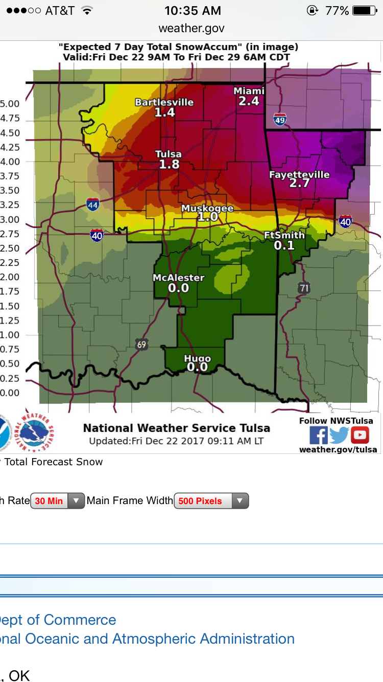
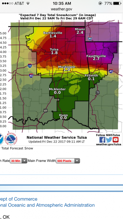
This is their 24 hour snow total, but their 7 day snow total has amounts of about half this. Not sure what the disconnect is. -
MO/KS/AR/OK 2019-2020 Winter Wonderland Discussion
MUWX replied to JoMo's topic in Central/Western States
Not sure how to link it, but doug goes with 1-3 for southern Missouri and northern Arkansas