

MUWX
-
Posts
1,241 -
Joined
-
Last visited
Content Type
Profiles
Blogs
Forums
American Weather
Media Demo
Store
Gallery
Posts posted by MUWX
-
-
There are some pretty significant differences in how the 12z nam and 6z GFS are handling the cold air as well.
At 06z Saturday the difference between the two is nearly 15 degrees for Springfield.
-
4 minutes ago, NwWhiteOut said:
Would not shock me the least, is why I am glad my brain cant wrap around the models or I would be in for constant disappointment lol. One of these times we will get something, maybe. Will probly be like any other storm, turns cold after it leaves and heads by with flurries at best haha
Only going to be cold for like 24 hours. Then back to the 50s and 60s
-
Really starting to feel like this one is going to end up just like every other storm has for the last half decade.
-
Just now, MoWeatherguy said:
Take a step back and look at what ur assessing, it's an 18z run!
Take a further step back and look at what your really assessing, a modeled snow storm in the four states area!
-
 1
1
-
-
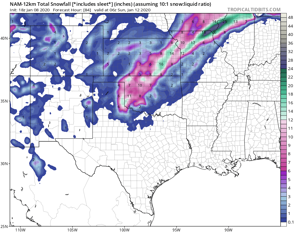
Seeing the heavy snow in OK/AR headed North east at hour 72, go poof by hour 78 is very depressing for the SWMO folks. haha
-
2 minutes ago, JoMo said:
Probably where things will eventually end up.
The only model that doesnt agree with the northern solution is the Euro. Im happy that the euro is on our side, but its very concerning that its the only one. Hoping for some light snow at this point, definitely not convinced we even get that at this point.
-
11 minutes ago, StormChazer said:
Closes off quickly and then grazes by...I'm glad this run is 72 hours out and not 36... just need it to scoot a little east....

That run looks a lot like the majority of storms from the last 5 years, close... but not close enough.
-
Just now, JoMo said:
Yeah, Thurs morning the system will be over northern Cali.
So likely wont see that data in the models until the 0z runs tomorrow night?
-
16 minutes ago, StormChazer said:
06Z GFS and 12Z GFS looking for the most part the same, with the exception of slightly lighter amounts in Western MO.
12Z NAM vs 06Z has the system wrap up in KS as opposed to OK, backs off of snowfall in OK to around about an inch, and bombs in KS.
Overall, GFS holds steady after jumping more towards the Euro overnight(good to see the 12Z run of the GFS do that, as the 06Z and 18Z can be unreliable).
Will see what the Euro does, I've got to think it's going to move the goal posts a little bit and go a touch north after shifting so far south(as models tend to do until they hit a nice in-between).
All we need really is for the NAM to sync up with the Euro and we can start locking in a solution at this point in time.
Also, if you take any stock in the 06Z Euro, it maintains the overnight's thinking of a southern solution.
I still think we need to wait at least another 24-36 hours before we start talking about locking a solution in. When will this be fully sampled?
-
Gfs takes another step
-
 2
2
-
-
18Z GFS needs to shift 100 miles south.
-
1
-
-
Im still not sold on the euro because of the ensembles. The 0z ensembles were somewhat more encouraging than the 12z, so hopefully this afternoons is even better.
-
7 minutes ago, StormChazer said:
Thinking maybe this GFS run is shifting towards the Euro.
Seems like a stretch. I think the 0z looks better than they 12z does. The 12z gets its act together to far east.
-
10 minutes ago, Doramo said:
I like this fantasy, a YouTube forecaster , David Schlotthauer 's current take (ps I don't know how to resize this to be smaller ,sorry if it is too big )

projected forecast we may be in for a dilly...
Meh. He’s running with the euro op, which has very little support.
-
1 minute ago, lokee said:
00z GFS still pushing everything up into Kansas.
Pretty similar to the 18z. All north. Has been the trend for the last 5 years. Going with persistence forecasting with this one. Expect the same result, until something proves otherwise.
-
GFS is way north also. Might see some mix around here, but that is most likely about it. Several days out and plenty of time to change, but with 5 straight years of misses on our side, I don't see any reason to believe this one will be different.
-
5 minutes ago, StormChazer said:


Disappointing to say the least, but not surprising.
-
Anyone had a chance to look at the Euro ensembles? NWS mentions that the GFS ensembles were unimpressive.
-
The GFS is certainly interesting.
-
Jeremy warriner says the system at the end of the week is looking more interesting for some snow, did the euro do something? Haven’t had a look yet, but I know the GFS And the Canadian weren’t anything special.
-
Getting some very light snow in republic currently.
-
1
-
-
49 minutes ago, JoMo said:
It's more difficult to get snow the farther south you go. More things have to go right in order for that to happen. If the timing is off, then it matters more than if the timing is off in colder locations to the north. Everything has to be more perfect the farther south you go in order for it to snow. Doug's winter forecast has been awful the last few years. The models have been awful as well.
There are signs of colder weather ahead as the atmosphere will reshuffle. Will that be good for us? Not sure, yet.
EDIT: The GFS is pretty much trash in the long range. The EPS (Euro) is easily outperforming it. With that being said, the EPS shows a -EPO coming up which should dump cold air into the US, the question is if it dumps it into the west coast, or if it dumps it down the Plains. It has a -PNA look long range.
It’s always about timing, but there has to be more to it than the timing is just off. I can buy that for a year or two... but not 6.
-
1 hour ago, StormChazer said:
I don’t think I really buy into that theory. Also let me start by saying this is motivated ZERO by politics.
If you look at the numbers,
2005-2010 was the 2nd snowiest stretch for Tulsa since accurate/reliable record keeping in the 1950’s.
2010-2015 was the 6th snowiest on record.And 2000-2005 was the 5th.
I’d find it hard to believe we could go from those kinds of record breaking numbers to snow drought in just a matter of a few years if it were climate change related.
I know amidst our frustration it’s easy to want to find a reason as to why this all is happening because having a solid reason makes us feel a little better and a little more in control.
But the truth of the matter is, we’ve just been REALLY REALLY unlucky, the pattern hasn’t been super favorable and when it has, we’ve just BARELY been on the warm side of things. Most of Missouri the last few seasons has been getting above average snowfall. It’s just luck of the draw sometimes.
Well go through more heavy snowfall periods in the future and look back at this stretch as being an anomaly.
It’ll get better. It just stinks right now.
When you say that we have had favorable storm tracks, but we have been barely too warm, that could be climate change. A degree changes every thing. At some point, this becomes more than a drought.
-
13 hours ago, NwWhiteOut said:
Bleh, seems like we are heading down the wrong path again this winter lol....wash and repeat yet again. I know I know it's early still but these overly warm holiday temps just make me nervous as its the same ole same ole as the last 5 years or so.
Not trying to derail the thread, but Doug has said multiple times now that he thinks climate change is to blame. In one post he said it’s possible we only get one 6” snow a decade now, due to climate change.


MO/KS/AR/OK 2019-2020 Winter Wonderland Discussion
in Central/Western States
Posted
Lets lock that in. The differences in the cold air continue between the NAM and the GFS