

StormchaserChuck!
-
Posts
2,273 -
Joined
-
Last visited
Content Type
Profiles
Blogs
Forums
American Weather
Media Demo
Store
Gallery
Posts posted by StormchaserChuck!
-
-
I think we have a pretty good chance for -PNA Jan and Dec, because we are running pretty perfectly opposite of last year. Last we actually didn't have a good Pacific. I think we have more potential energy for snow this Winter, but the N. Hemisphere pattern looks like it could be worse.?
-
-12 months, yeah. We had a pretty good +EPO last year with nothing surrounding it +months, so with the mirror thing that has been happening for 2 years now, we are 85-90% likely to see -EPO in October.
-
-EPO October's are associated with higher hurricane activity at like 300% in the last 10-20 years.
-
 1
1
-
-
Can someone take the "!" out of my username?
-
 2
2
-
-
I think it's something like 85-90% chance we will have a -EPO October
Models have a nice 3-load -PNA for September.. fits the trend of a longer late Summer.This should take us right up until the end of September.


-
1
-
-
17 hours ago, jlewis1111 said:
Food for thought there has only been 5 August's with not tropical cyclones in the atlantic. They were all followed by el nino or neutral winters. None were La nina. Will see This past August now makes 6
That's a pretty good assessment. I wonder if we are running into the potential energy of an El Nino next year.
-
1
-
-
13 hours ago, snowman19 said:
I would put the chances of a 13-14 or 14-15 style +PNA/-EPO on roids winter at very, very low and extremely unlikely, those winters were driven by ++PDO. Despite what I’m seeing from some of the twitterologists, besides this year having super low Atlantic ACE, it is nothing at all like 13-14, like not even in the ballpark of that year
We are running closer to 10-13 than 16-21 imo. If we do a big/huge +NAO like +2, the EPO will probably go negative.
-
I still think this -NAO will overperform warmer than average, like they all have.
-
 1
1
-
-
8 hours ago, Typhoon Tip said:
This is the 1884 --> 2021 aggregate temperature difference.
hmm.. wind is the biggest variable.
-
Watch out though that the last 3 +QBO/La Nina's have been cold-surface,-NAO's tendecies. (10mb obviously amped.)
.png.c61972565ed95b848e602e995d74d9a8.png)
-
Strong -PNA signal in Jan/Feb, especially with La Nina. I don't think there has ever been a La Nina on satellite record that did not have a +anomaly in the NPH (North pacific high) region north of Hawaii. I think 95-96 is it, but that was after 8years of +ENSO in a row (the longest streak since 1800s). -PNA will correlate to -NAO, so watch out for maybe +NAO Dec and Mar if the leading indicator signals are right. My NAO index for DJFM has 50% chance of falling +0.16 to +1.24 for DJFM
vWatch out for a +NAO December
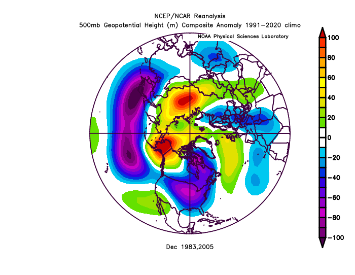
2005 and 1983 were cold though
-
1
-
-
We really had a strong pattern in 2012-15, 4 Winter's H(Pacificwater), reverse the next 6, then go back to 12-15/like last year.
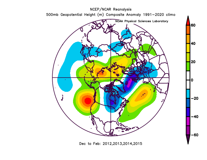
setting up the same general this Summer ^
-
1 hour ago, WinterWxLuvr said:
-PNA?
More than likely.. if it's +NAO though like some strong signals are pointing to it will be either -EPO or +PNA
-
Probably not getting really cold this Winter
-
2
-
-
Would love to see this in the Winter
.thumb.gif.5116947dedbbf92d47ee1c76e12c1416.gif)
-
90% for 4 days, and 88%day3
-
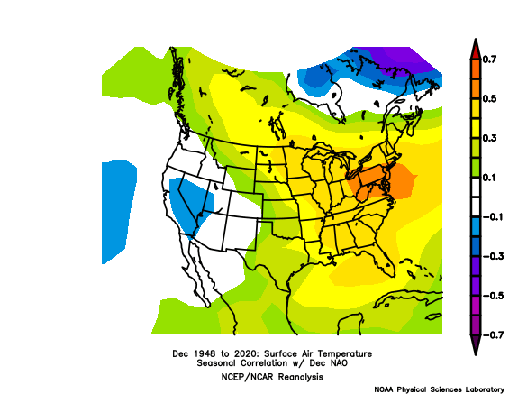
Just really warm in our NAO-box area for the Winter (0.54SD correlation).
.thumb.png.bd84992b2c26ab90db4d67b03d605921.png)
-
1
-
-
Really warm near NF
.thumb.png.9212aaf43550fceb2737afc35cd4e1b0.png)
In my experience +NAO SST signal (May-Sept) + La Nina/+QBO is a confirmation +NAO Winter, meaning it continues/correlates/holds
-
DCA +4 NYC +4 BOS +3.5 ORD +3.5 ATL +3.5 IAH +3.5 DEN +3 PHX +2.5 SEA -1
-
 1
1
-
-
I like teleconnection indicators.
-
Yeah, I've been noticing the subsurface and surface ENSO have not been connected, re: subsurface-N. Pacific correlation.
I said that 3-Nina's have not been all warm though, so the pattern disconnection isn't so anomalous, historically speaking.
-
It seems like we are trending an EC trough this Summer..
All the index-measurements are warm/+NAO+AO
-
Underperforming Atlantic La Nina seasons (1955, 1973, 1974, 1975)
-
2
-
-
We may have a -NAO tendency (despite 4/4 opposite-indicators), and maybe -EPO, switching off between the two a little. +PNA, if we could do it, would be really impressive.
-
 2
2
-


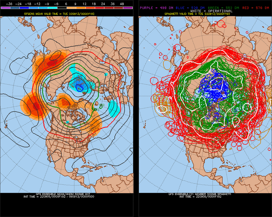
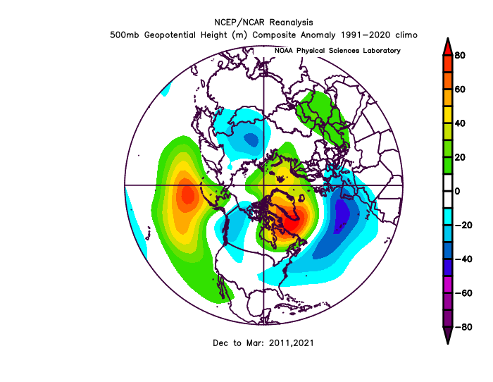
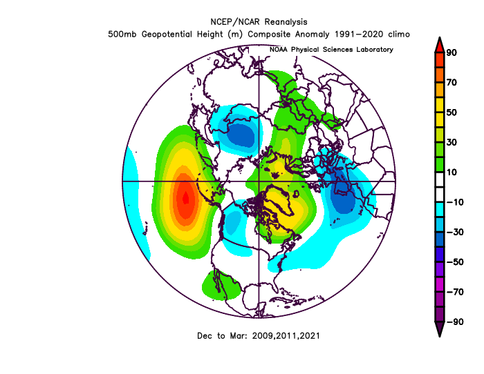
.gif.c5eb8357db37b7c0e6e2ecb369bf74fe.gif)
.png.f12eeb080dbbc29f79c35df43bff6c16.png)
.png.1aeaa0062a02d750a3a35a074604b6fc.png)
Winter 2022-23
in Mid Atlantic
Posted
Pretty good signal for +NAO Dec, maybe with -EPO or+PNA