

Itstrainingtime
-
Posts
16,376 -
Joined
-
Last visited
Content Type
Profiles
Blogs
Forums
American Weather
Media Demo
Store
Gallery
Posts posted by Itstrainingtime
-
-
8 minutes ago, Atomixwx said:
I'll umpire softball. Plate assignments only.
Sent from my motorola edge 5G UW (2021) using Tapatalk
Angel?
-
 1
1
-
 2
2
-
-
Holy moly, a tropical-like deluge started here out of nowhere. Radar suggests some big totals incoming - I'm already at 1.31" for the day.
-
1
-
-
24 minutes ago, mahantango#1 said:
How much more rain will we receive the rest of the day?
Maybe 1 to 2"?
-
1 minute ago, Bubbler86 said:
Gust to 56.
Wow!
-
Just hit 1" of rain today.
3.53" since Monday.
3.75" since Saturday.
14.83" YTD.
And it is pouring...
-
1.46"/2.49" today and 2 day total.
2.71" since Saturday.
-
1
-
-
38 minutes ago, TheClimateChanger said:
Below normal? I wish. Not so here.
It is in almost the entirety of the thread that you posted in, but you knew that.
-
1
-
-
1 minute ago, TheClimateChanger said:
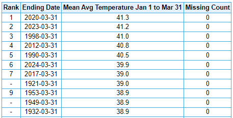
As we round out the first quarter of 2024, I thought it might be a good time for a review of temperatures. Through the first quarter of 2024, it's been quite toasty in central Pennsylvania.
Williamsport: Third warmest start to the year [of 130 years], behind 2012 & 2023.
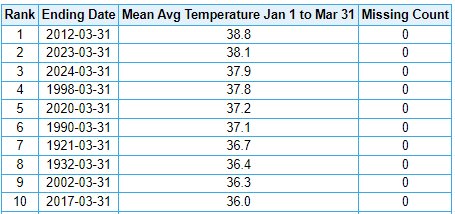
Harrisburg / Middletown: Sixth warmest start to the year [of 136 years], behind 2020, 2023, 1998, 2012 & 1990.
You probably shouldn't think so much. Just enjoy the BN temps today.
")
-
12 minutes ago, Bubbler86 said:
Some people may get more precip Thursday than they do today. Those pop up showers mean business and could drop 1/2 to 1" if you catch several.
Thursday is definitely a wild card - CTP says less than a tenth of an inch. I tend to agree with your assessment.
-
1
-
-
MU still hyping snow and graupel on Thursday - "funny things happen under upper level lows..."
-
2
-
-
1 minute ago, Bubbler86 said:
You are going to pass my since Saturday total which is still at 2" after just drizzle for the past 5 hours,
At this moment I'm at 1.36" for the day, 2.39" since yesterday and 2.61" including Saturday.
-
.30" in the past 15 minutes.
-
1
-
-
Thunder and heavy rain.
-
1
-
-
Could be some minor flooding later in the week on the main stem Susquehanna- flood stage at Marietta is 49'. By late Thursday the river is expected to reach 48.8" and it's still rising.
-
So far today, .89" of rain has fallen. 2 day total is 1.92".
-
1
-
-
54 minutes ago, Atomixwx said:
That's a bit concerning.

Sent from my motorola edge 5G UW (2021) using Tapatalk
I know people in here are focusing on one last potential wintry threat, I certainly respect and understand that. But the bigger story to me in the next 48 hours is the severe threat that's unfolding not too far away from us. I feel that the pretty colors aren't finished moving towards us, too.
-
1
-
-
2 minutes ago, Bubbler86 said:
Nooners...back to Mostly Cloudy and 50 degrees.
Mostly cloudy for sure here- but an impressive amount of blue skies overhead. Sun has been out in pretty much full force for nearly 30 minutes so far.
-
1
-
-
2 hours ago, mahantango#1 said:
I see NWS forecast mentions thunderstorms in my forecast tomorrow.
Thanks for mentioning this - with the storm track a bit farther north, the chance of storms here increases accordingly. Would not be shocked if we get a low key severe threat in the southern tier tomorrow night.
-
 1
1
-
-
19 minutes ago, Bubbler86 said:
It became partly to mostly sunny here not long after I posted that.
8 minutes ago, canderson said:Sun's out.
Sun has made an appearance here as well.
See - nice week in tap.
-
1
-
-
16 minutes ago, Bubbler86 said:
48 and we just hit the 1" mark for the current rain with 1.38" since Sat.
1.22" since Saturday here - 1" on the day. Rainfall rates just increased again.
-
1
-
-
14 minutes ago, Mount Joy Snowman said:
Yeah looks like I'm approaching 3/4" now. I ended March with 4.65".
I'm at .94" today to be precise. Great start to our rain totals.
-
9 minutes ago, Bubbler86 said:
I was hoping for sun today. It is low 50's. I did not need the fireplace but parents wanted it.
My family and extended family didn't want the AC on...
They lost.
It is quite overcast here as well.
-
1
-
-
1 minute ago, Bubbler86 said:
Fireplace is on for Easter.
It got too warm inside for me this morning - AC is running.
SPC has R-Ville under a SLGT for severe weather on Tuesday.
-
Mostly cloudy and 55. Sun was out earlier but is taking a break now. Needs to rest up for all of the sun coming this week.
-
1
-
Central Pa. Spring 2024
in Upstate New York/Pennsylvania
Posted
Heavy thunderstorm in progress- lots of lightning and tremendous rain rates. Wow.