

The Iceman
-
Posts
11,638 -
Joined
-
Last visited
Content Type
Profiles
Blogs
Forums
American Weather
Media Demo
Store
Gallery
Posts posted by The Iceman
-
-
Looks like the heaviest rain will stay in NJ looking across the 12z models. Only the 12k NAM gets 1-2" totals into SE PA. The euro has barely anything.
-
We're going into a super nino, there will be no downward slide into winter

-
 1
1
-
 1
1
-
 1
1
-
-
My uncle in Live Oak said winds have started gusting 50-60 mph in the last 15 mins.
-
26 minutes ago, Birds~69 said:
Had 3 or 4 decent/steady sun showers this afternoon. Nothing severe.
Mowed the lawn Sat and could easily mow it again tomorrow. Green and thick is abnormal for Aug but good. This may be a early indication for a stellar winter...

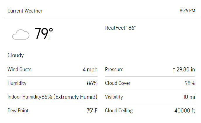
79F/DP 75F
Hope you’re right, lord knows we could use one after last year’s flaming pile of shit. I’m a little concerned about el nino being too strong and flooding the continent with warmth… but as long as that doesn’t occur we should do well. Nino winters typically are good in these parts.
-
2.3” on the day after that last heavy shower.
-
18 minutes ago, Blizzard-on-GFS said:
Waiting from them to drop a TOR warning on that bucks county cell. Rotation keeps strengthening
That area passed right over me, nothing ominous.
-
90% chance of rain with 1-2” forecast = .02” of rain
30% chance of rain with .1” of rain forecast = 1.75” in 30 mins.
It never fails!
-
1
-
-
0.02 overnight… that flood watch was totally necessary…brutal forecasting by pretty much all outlets.
-
1
-
-
Looks like most of the rain will slide to our NW barring any development. Mt Holly went from 1-2” for tonight this morning to .25-.5 in the evening forecast update. Will be shocked if we even get that. Guidance showed this exact scenario beginning last night. I bet the sprinkles we got 30 mins ago is going to be it. Should of watered the plants….big ole bustola incoming. At least it’s not a snowstorm…
-
Not too bad here, maybe 35-40 mph winds tops. Heavy rain was the main feature. Thankful to be honest, really didn’t feel like messing with the generator tonight. Impressive temp drop behind the storm down to 70F. Feels great outside now.
-
12z guidance really doesn't bring any further clarification for our area. There's still 2 distinct camps. The NAM and HRRR both weaken the convection before it gets to SE PA while some of the CAM's and RGEM bring a strong line through the area in the 6-10 PM range. Will be interesting to see which verifies.
-
 1
1
-
-
MT holly mentioned that there's concern that the stronger convection to the south of us robs potential convection to the north and I agree with that thinking. Guidance is currently split on whether intense convection makes it into the region later on. I think the bust potential is unusually high today.
-
2
-
-
.70” in 10 minutes, 30-40 mph wind gusts. No thunder or lightning though. Feels great outside temp down to 78.
-
1
-
-
Zero rain round one and round two will probably fall apart before it gets here. Story of the summer…sitting with only a little over 8” since June, about 10% below average. Pretty unreal.
-
0.00 on the day still, line already starting to fizzle out and accelerate. Will probably be lucky to get .25” lol
-
1
-
-
1 hour ago, RedSky said:
All the missed showers over the last week all in one shot it's what I do
I got .10 in the last week. I’m even more cursed than you. Today looks like more of the same.
-
11 minutes ago, Hurricane Agnes said:
They posted a PNS for the assessment of 2 tornadoes but neither there -
I know sometimes it can be difficult to pick out a tornado if rain-enshrouded but I expect they go by both radar-indicated and nearby spotters. You can go through the LSRs for 6/26 - 6/27 here to see if there are any from your area - https://www.weather.gov/wrh/TextProduct?product=lsrphi
As an obs, there is a strange orb in the sky that I haven't seen much of the past couple days that was not trying to peep out between a deck of clouds.
I bottomed out at 64 this morning and am currently at 73 with dp 69.


-
1
-
-
1.35” today, 3.4” in the last 2 days.
-
1
-
-
2.05" overnight, .10" so far today.
-
Looks like I tempted the rain gods and they are now about unleash a deluge of all deluges. Part one dropped .80 in 20 mins, all that stuff in Philly now looks lined up for here.
-
1
-
1
-
-
Lol getting a few pity drops at least… swing and a miss.
-
2 minutes ago, Hurricane Agnes said:
Looks like you should be having some incoming though...
Going to be close call, looks like it’s gonna slide a mile or two to my west currently unless that line extends a little bit further. I’m on the far east side of Levittown, as far east as it gets.. literally across the canal is technically Morrisville.
-
Complete bust here, got maybe a .10 earlier today but that’s it.
-
1
-
-
Didn't get totally shut out but we were in a relative hole compared to locations 5-10 miles east and west of me. Picked up .25" from our brief storm.
E PA/NJ/DE Fall 2023 OBS/Discussion Thread
in Philadelphia Region
Posted
.39" well below the 1-2+" forecasted