

The Iceman
-
Posts
11,638 -
Joined
-
Last visited
Content Type
Profiles
Blogs
Forums
American Weather
Media Demo
Store
Gallery
Posts posted by The Iceman
-
-
3 minutes ago, JimE said:
Tricky situation, though. Rain washes away the salt, but if the ground remains cold enough, the rain freezes on the surface. So it's a question of when, where, how much to put down. Some places are predicting small drops in temperature to 31, 32, 33 overnight which could make some roads treacherous tomorrow morning. These types of storms (snow to mix to rain to mix to rain to snow) are a challenge not only for forecasters but for road crews.
My area isn’t even supposed to get below freezing though. We don’t have a WWA. It’s going to be above freezing when precip starts and won’t fall below freezing until Sunday night. Complete waste of money and resources in the 95 area.
-
 1
1
-
-
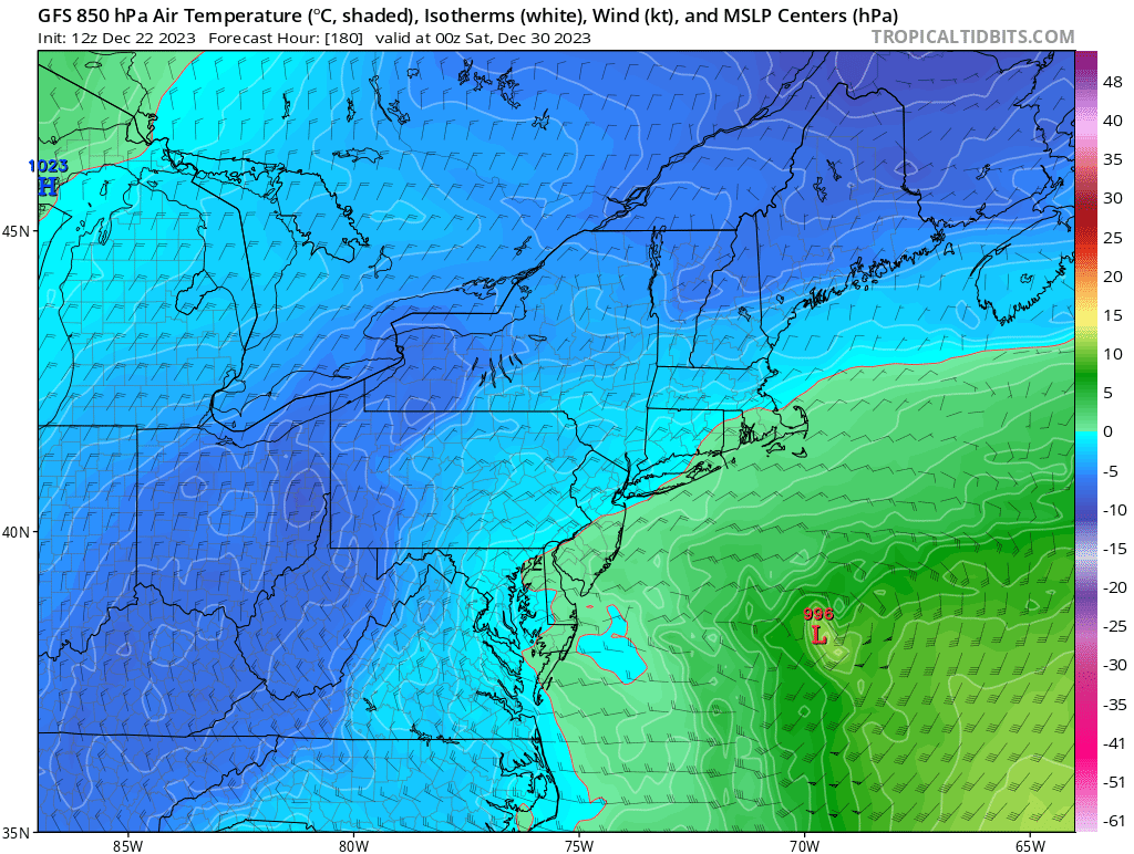
Salt trucks out in full force this morning for what should be 99% rain here. Guessing the municipalities and pendot are itching to use some of their excess stock from the last 2+ years… what a waste though.
-
1 hour ago, Ralph Wiggum said:
I actually preferred the shut-the-blinds pattern tbh. At least we werent wasting our time chasing our tails. This is becoming yet another one of those seasons where MR/LR offer teases which fall apart as lead times shorten.
This pretty much has been a shut the blinds look and it looks to continue until at least MLK day at least for the coastal plain. I never bought in to this storm for 95 and burbs because the issues with cold air were pretty apparent even when it was showing snow in the MR. I expect most of the LV to be disappointed as well if they are anticipating a warning level event. 2-4” will be much more common than 4-8” with much more mixing than they currently expect. Poconos should do well though. Now if the block gets as strong as the models are indicating, I honestly expect we get a cold/dry pattern with a southern snowstorm or 2 before we see anything significant. I think late month coming out of the block offers our best potential. Unfortunately this winter is looking more 2016 than 2002.
-
Still has nothing-burger written all over it for 95 areas imo. 10-15 miles N and W of should get a decent 3-6”. I’ll be surprised if we see an inch here though.
-
1
-
 1
1
-
-
Expecting nothing but cold rain. Good luck n and w folks.
-
 1
1
-
-
1 hour ago, Ralph Wiggum said:
December 29 and this is where we are? What does it take anymore?
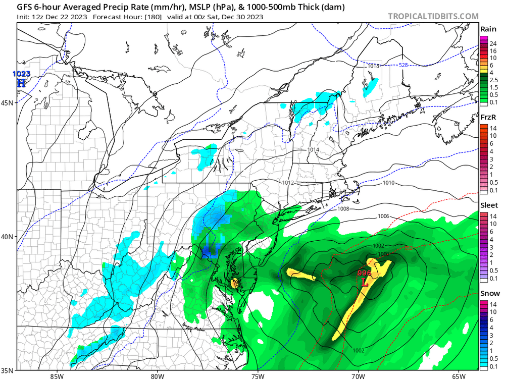

surface temps are like in the lower 40's that's why.
-
Only 372 hours out! The big ones are sniffed out early

-
 4
4
-
2
-
-
25 minutes ago, Ralph Wiggum said:
My daffodils are coming along nicely

Kind of related, my dad put down a fall blend grass seed wayyyy later than he should have, like the week before thanksgiving and I was giving him shit about it saying there's no way in hell that you're getting anything to sprout. Stopped by yesterday and sure enough there were a few spots that actually sprouted under the hay...
-
Yeah the good in the LR is you can see the STJ open up for business. The bad is + NAO and marginal airmasses mean most likely wet instead of white. However, if we see that train of gulf lows continue deeper into climo, it's hard to believe that one won't be wintry and as 2016 showed, you only need one to make it a memorable winter.
-
1
-
-
2.2” of rain, like Mike said above if it snowed at the end, I didn’t see it. Maybe January will deliver?
-
Wind threat starting to emerge on Sunday Night... Won't be difficult to mix down if we get some convection.

-
1
-
-
Flizzard in Trenton
-
1
-
-
3 hours ago, Ralph Wiggum said:
It does look like a window of opportunity. One trend I've noticed this past month....when guidance has shown a coastal low at range it has generally morphed into a fropa or developed well offshore as verification. So we need to watch that to see if this also moves that direction. Saw this alot past few seasons. Could be the lag of the Nina pattern still moving into Nino looks which hopefully start to show up more as we head into late December onward. Still think we need to be patient...Nino December's aren't usually known for cold and prolific snows.
exactly what the 12z GFS just flipped to in that range

-
1
-
-
8 hours ago, RedSky said:
In bee news the yellowjackets are back today, on December 2nd. Ain't ever seen anything like this, oh and a fly.
* And a honeybee lol
One came out of the siding when I was putting up the Christmas lights today, nearly fell off the ladder. Was not expecting it at all with the multiple freezes we’ve had.
-
-
Good vibes only

-
1
-
-
I think the 5-10th time period bares watching. Right now just successive rain events but those successive wave trains are how we can score early in the season. This is long range OP runs but verbatim the gfs is close to some white if that northern stream vort digs a bit further.
-
1
-
-
On the board here in Levittown. Enough to whiten the ground so saying .1 instead of a trace. It was coming down good for a solid 5-10 mins though. Was a pleasant surprise this morning.
-
1.9" storm total. Nice little fall storm, we were howling as the LL jet got cranking last night.
-
1
-
-
Ensemble chaos when it comes to the NAO as we head towards the end of the month...some members go solidly negative while others stay solidly positive... We can still score in a positive regime if other factors are in place but if the NAO goes strongly negative, I think that's a good sign for the impending winter...

AO looks to on track to tank(one of the most important factors for December snow if I'm remembering @donsutherland1's statistics correctly from years past) and the PNA looks to stay slightly positive. EPO based on modeling looks to be negative as well which should provide cold either nearby or over us... indices overall though looking good entering December especially if the NAO cooperates...
-
If we get this look throughout the winter we will do pretty good I think

-
I was never really enthusiastic for last winter, I thought we had a decent chance at a frontloaded winter but when we got skunked in that decent pattern in December last year, I kind of knew we were fooked. At the time, I didn't think complete shut out, but I did think it would definitely be a below average winter... I feel the complete opposite this year. You have to like where we are at heading into December... I'm thinking at minimum we get our average snowfall with a higher chance than normal of above normal. I think the only way we finish below normal is if the Nino goes ballistic which is looking unlikely right now. But even if it does, 2016 showed us you only need 1 storm to go just right to have an above normal winter even in a super nino. I don't think we see a super nino though, I think it tops out at strong and in this case that helps us overcome the crappy Nina base state in the pacific we've had the last 3 years. 09-10 is not a terrible analog tbh, not saying we see those totals but hell even if we only received half of those events in 2009-2010 it would have still been a solid above normal winter. If I had to take a guess right now, I would go with 95 area finishes 25-35", N and W gets 35-45". Things look to be heading in a good direction as we head into December and I think many of us are on the board before Dec. 25.
-
1
-
1
-
-
Disclaimer: This post is not meant to be taken seriously, I have no idea if the patterns even resemble each other, and I'm not saying it's going to be a redux however I'm just going to say it... this variability in temps to start the month reminds me of the beginning of November 09. That month also started out very dry. Also was a strongish el nino coming out of a multi year nina. Just saying...
Now let the buns fly 
-
1
-
-
On 11/8/2023 at 9:13 AM, Ralph Wiggum said:
Buckle up
But in all seriousness, the week of TG looks like a nice step down to a colder regime on the ens means. Trof in East, disturbance(s) under the region, ridge in Western Canada. We take what we can get. I'd rather punt Nov for a better heart of winter tbh if I had a choice.
Yessir, buckle up indeed. You have to like the upper level pattern being shown late month on the ensembles with ridging building in the west with a nice -epo look and a trough in the east with maybe a period of transient blocking in the Atlantic thrown in. Obviously the volatility with the models of late(to be expected this time of the year), it'll be getting that look to progress in time but I think we eventually see nice window for potential first flakes or more late this month into early December at least. I think things are progressing about as good as possible for this winter. Looks far from the typical el nino blowtorch early winter that you see sometimes in strong nino's where you're holding out for a pattern change to save the day in late jan/early feb. Thinking this year could be shaping up to be an active at least first half of December where we could score a decent snow before a thaw period late month or early jan as the pattern reloads again for even better potential late jan/feb when we hit the heart of climo. At the very least, I'm very confident that we will all do better than last year!
-
1
-


Philly Area Banter
in Philadelphia Region
Posted
You can be a fan and acknowledge that this team fucking blows. Expect a quick exit next week with baker mayfield throwing for 400+. I think the entire coaching staff, Sirianni included, needs to be overhauled. If they don’t completely overhaul the staff, they are going to ruin another qb after giving him a huge contract and will be under .500 for years to come. I don’t know how they can even rebuild or retool the roster with their cap situation so they need to completely retool the staff. Otherwise there is going to be nothing but pain going forward. Really hope Kelce retires… this teams window is shut for years to come.