-
Posts
763 -
Joined
-
Last visited
Content Type
Profiles
Blogs
Forums
American Weather
Media Demo
Store
Gallery
Everything posted by tuanis
-
Let's get this show on the road! Can't remember the last time things felt so locked and loaded in the Chicago metro for days leading up to a winter event. Sidenote: I re-read the Iowa derecho thread last night for the first time since the event and thoroughly enjoyed it. Recommended!
-
^ what a dick On the hype front, I haven't been watching the local news, but Skilling has been geeking out on FB. Just kidding Ricky, you da man.
-
Apparently it's time to call it. 8.5". Dry air not an issue this time around, but ratios may struggle. However, they often seem to do better than expected in heavy banding, so I could be low-balling. Looks like a serious thump for several hours before it wanes. Got a hike planned into the backyard forest preserve and over to the ol' sled hill around 9 PM Saturday night. Hoping it'll be ripping hard. We'll have a more-than-solid 14" OTG if my prediction pans out. January 2019 was probably the last time we had snow that deep.
-
The consistency is delicious. I assume if everything holds at 00z tonight, it's all systems go from LOT. That much QPF is gonna be a big cleanup job.
-
Famous last words. The caveat is the thermals. How far north does mixing enter the picture? The main forcing should be snow, but I could see it getting pretty sloppy/drizzly after that passes through.
-
A bit off topic, but totally related to this system while watching the medium-to-long-range evolve on the models. Quite a pattern change that has taken place in our part of the world. Delayed but definitely not denied. February looks kind of sexy.
-
Pretty sweet consensus, no doubt. Crazy evolution. I can't really remember a storm emerging into the plains, blowing up a huge precip shield in nearly all directions, then quickly weakening/starting a transfer to the coast. It all seems to happen so quickly as modeled. Wonder if next week's system will finally break through that "block"? Kind of reminds me of watching a Florida-bound hurricane race under a stout Bermuda high. When will it turn??
-
Agreed. It's going to be awesome watching this thing explode on regional radar too. Too bad it'll be at night,
-
I’m feelin a Peoria jackpot
-
Reminder of what models were thinking for the last system 3-ish days out...
-
How can we custom order a juicy cutter that lollipops both Peoria and McHenry County? Secondary low forms and dumps on northern/central IN, bringing them all above normal for the season. Would make these storm threads easier to read. If we learned anything from the last one, nothing is set in stone. I imagine plenty of surprises to come with this one. QPF was way overdone out this way, even with an open gulf. Let's see if that plays into our next system as well.
-
Maybe it was the guy in Cary.
-
On this past storm you were worried about a miss south until 24 hours out. The best banding ended up NORTH OF MADISON. You should like where you sit with this one. Besides, doesn't the lake help out in lakeshore counties in most mid-winter snowstorms around here?
-
Looks about done here. I better get outside to blow the driveway again and get a few more measurements before it gets dark.
-
Visibility still reduced and still accumulating, albeit much more slowly. Have about an inch and a half of fresh on the driveway since I cleared it this morning. Imagine we've seen about 7"-7.5" so far, but hard to get an accurate measurement with the blowing and drifting. Rates picking up again as I type this. It's not really a packing snow. More dense and powdery.
-
Dumps like a truck in this weenie band
-
Measuring 5.5” on the driveway that I’m about to clear.
-
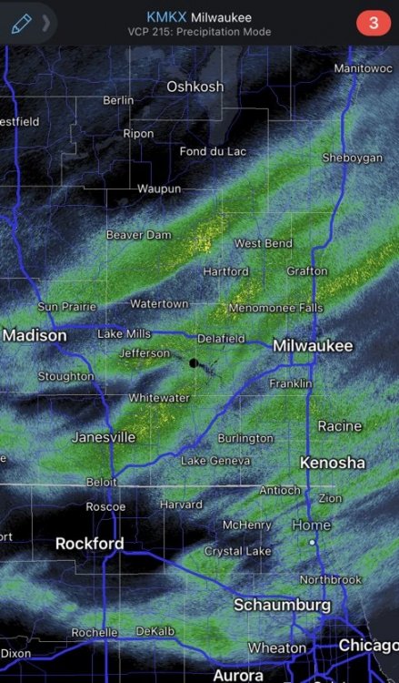
Those lake enhanced firehose bands north of Milwaukee look sweet. They’ll pivot south with time while convergence/lake effect parameters improve. We’ll see what they look like once they make their way down here.
-
These lake enhanced bands are impressive. Eyeballing it, looks like about 5” or 6” out there so far, but I have yet to have my morning coffee or take a measurement. Really blowing around. If this keeps up into the afternoon we could end up near double digits.
-
Goodnight y’all. It took until midnight, but it’s finally doing its thing out there. Hope it keeps up while I sleep.
-
Of course LOT goes down. Just stepped outside. It feels like a mid-winter storm. It's gusty, the little snow that has fallen is blowing - it's not a wet snow. The flakes that are falling are aggregates, there's just not a lot of them. You'd think the gusts would tear them apart.
-
A total flip from what's been modeled for days and what's still in the LOT forecast graphics.
-
March 12-13, 2017. I recorded 14" of LES IMBY. It can happen!
-
This banding does give hope for the rest of the night. If one finds themselves sitting under one of these bands, the reports of solid dendrites means you can really stack. Get the lake involved an all bets are off. Let's get these ingredients to come together.
-
Dryairpalooza. So much for this thing starting with a bang. DSM looks good though. Weird storm, but somehow fitting for this winter.


