-
Posts
1,137 -
Joined
-
Last visited
Content Type
Profiles
Blogs
Forums
American Weather
Media Demo
Store
Gallery
Posts posted by WestMichigan
-
-
16 minutes ago, Stebo said:
All but 5 track a low along the river or north. It is a very substantial shift north/stronger compared to previous runs.
There area a couple of duds in there but many of them are a decent to very nice hit across the southern 1/3 of Michigan. Would be nice to see that happen.
-
 1
1
-
-
5 minutes ago, Stebo said:
Need a little more east-west orientation and we can both be happy!
-
Take the Euro run and shift it west 50 miles or so and now we are talking. Like Hoosier said, odds of this happening are incredibly low.
-
2 hours ago, buckeye said:
so I had to check out the source, I couldn't help myself....after all we have a blizzard warning about once in 10 years around here....so several in one winter would be quite the feat. lol
His reasoning for the Big Blizzard area is based on his expection for frequent deepening low pressure areas off the new england coast due to unusually warm water in the northeast....(yes because we all know that's the classic textbook setup for big blizzards in Ohio and IN). I hope this guy isn't actually a meterologist.
I'll pass on the crushing cold.
-
-
8 minutes ago, A-L-E-K said:
Yeah, the lake is p much at flood stage all the time now
Yes it is. 2-4 foot waves trigger lakeshore flood advisories around here.
-
12 hours ago, A-L-E-K said:
Need to get a winter home on the lake in St Joseph
Wish my house was just a little closer to St. Joseph than it is.
-
I liked it better earlier in the week when the winds were more NW to WNW. Oh well, someone is going to get a lot of snow out of this. It is still early November.
-
7 hours ago, RogueWaves said:
Bunch-o-white rain here. Temps just couldn't get there in time to accumulate. Let's do this again in a couple months.
Same here. There were brief periods where snow mixed in, but in the end I still have green grass and a soggy yard.
-
 1
1
-
-
2 minutes ago, A-L-E-K said:
lake rise has been wild, amazing how little it takes to cause flooding/erosion issues at these levels
I have seen articles about houses that used to be 180' from the lake now have less than 10' of yard before Lake Michigan consumes their property. Crazy how much erosion has occurred in places over the last few years.
-
 1
1
-
-
Rain with an occasional wet flake mixed in west of GRR.
-
18 hours ago, buckeye said:
For the CMH crowd.... just WOW. Never in a million years would I have expected to see this.
When I lived there, he was a decent on air weatherman. Of course no one could top Ganahl for being a winter weather weenie, but Davis wasn't bad. Never would have guessed this.
-
While it was probably fascinating to see, I am glad I missed out on this.
-
 1
1
-
-
On 7/20/2019 at 2:30 AM, outflow said:
Grand rapids got hit pretty good 69mph gust at he airport. With the likely clearing later this morning and continued oppressive heat/humidity it isn't a good time for a metro area to have lots of possible power outages.
Consumers energy has 120,000 without power in west mi currently while Detroit Edison had 50000 from earlier storms around metro detriot
I can vouch for that. It was nasty on Saturday with no power! We went out and went from store to stay in air conditioning. Sleeping was a little uncomfortable Sat. night. We were fortunate to only go 34 hours without power. I have friends that they are saying Wednesday before they get theirs back.
-
1 hour ago, Hoosier said:
I haven't checked but anecdotally it seems like it's been cloudier than average for a while.
It has been in GRR
-
1.27" in the last 24 hours here. After a nice weekend back to wet. Hopefully farmers were able to make up a lot of ground over the weekend.
-
-
7 minutes ago, Chicago Storm said:
This tells us everything we need to know...you're out of your mind.
Winter 2013/14 was top 5 coldest and snowiest on record overall, and in other terms as well. Also 2013/24 being a -B and 1978/79 "only" being an -A is pure lol.
What you're looking for might not even exist on this planet, outside of mountainous terrain.
Siberia?
-
 1
1
-
-
19 minutes ago, weatherbo said:
Accumulating rapidly... a foot more likely still.
Can't imagine what your snow depth will be after this storm.
-
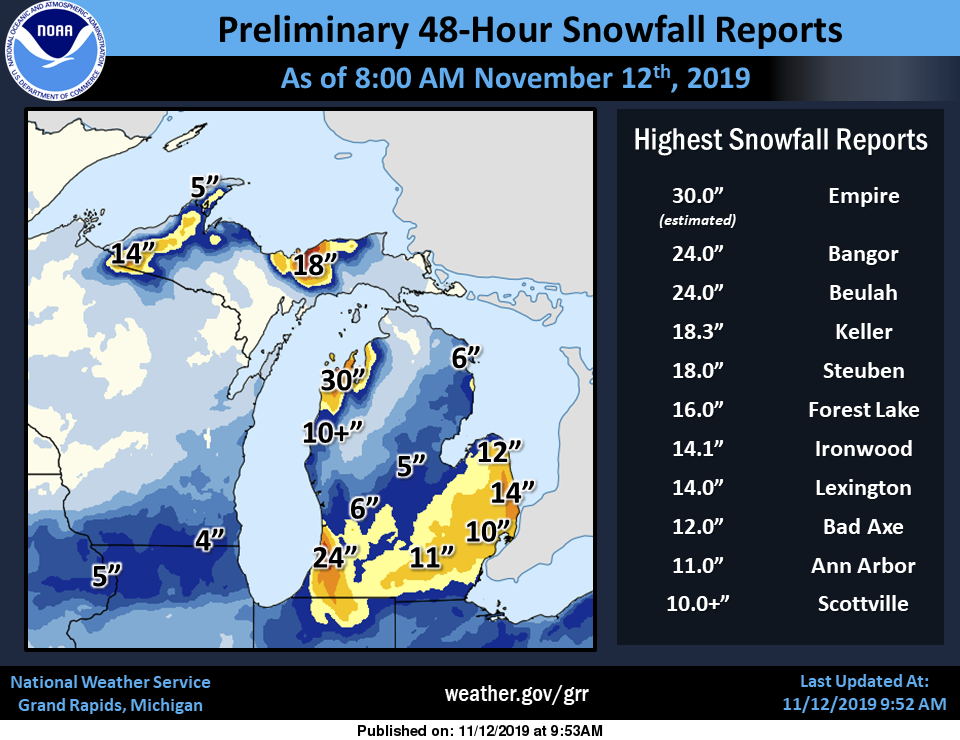
The winds have been very favorable for my area. Closing in on a foot of LES in addition to the system snow on Monday if I had to guess/ No real way to tell though with all the drifting. Nice to see most of the western part of lower Michigan getting in on the action this time.
-
20 hours ago, raindancewx said:
When I talk about Albuquerque, it is because as a location protected by 10,000-15,000 foot mountains only certain patterns can produce extremes here for cold, heat, or precipitation.
Wheeler Peak is the high point in New Mexico at 13,167 feet. I know you are generalizing, but you might want to not get too carried away in your stats.
-
 1
1
-
-
48 minutes ago, weatherbo said:
You have more snow on the ground on November 19 than the vast majority of the subforum will have at any time this winter.
-
3 hours ago, (((Will))) said:
Keweenaw-Northern Houghton-
Including the cities of Copper Harbor, Houghton, and Hancock
327 AM EST Thu Nov 8 2018

...WINTER STORM WARNING IN EFFECT FROM 10 PM THIS EVENING TO 7 AM
EST SATURDAY...

* WHAT...Heavy snow expected. Total snow accumulations of 9 to 14
  inches expected. Winds gusting as high as 35 mph.

* WHERE...Keweenaw and Northern Houghton Counties.
Nice, 3-5" in the forecast down here.
-
 1
1
-
-
Without repeating what others have said I will add April 4, 1987 in SE Ohio to the list. We had 24" on the ground of the wettest heaviest snow I have ever seen accumulate. It was 36° the entire time it snowed. The first 4 hours or so of snow during the daylight hours melted on contact, but once evening set in it started sticking to everything. This was basically a 24 hour snowfall so the rates were fairly impressive. It melted only a couple of days later, but I will never forget that one.
-
 1
1
-


December 2019 Discussion
in Lakes/Ohio Valley
Posted
Picked up 1.5” so far his evening and still snowing. Nice to see white again. Hope it makes it to your area tonight Rogue.