

WestMichigan
-
Posts
1,247 -
Joined
-
Last visited
Content Type
Profiles
Blogs
Forums
American Weather
Media Demo
Store
Gallery
Posts posted by WestMichigan
-
-
10 minutes ago, Hoosier said:
The funny thing locally is that there is decent agreement on ~4-8", but it gets there in completely different ways. On the northern end of the foreign models and on the southern end of the American models.
Like where you are better than where I am.
-
1 minute ago, frostfern said:
Maybe they are jaded because it always snows in their back yard. Lake effect is always lowballed in the favored areas. Some of them kinda dismiss events that aren't bullseyes for GRR itself too.
I think this is what Harry and Rogue are frequently complaining about.
-
 1
1
-
-
3 minutes ago, Jonger said:
Wow....NAM went way north.
NAM and GFS aren’t that far apart IMBY.
-
4 minutes ago, Natester said:
Ridiculous snow forecast totals. Totally overdone.
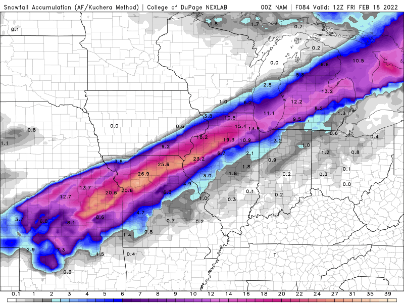
It is the NAM. Cut the numbers in half and you will be much closer to reality.
-
2 minutes ago, Powerball said:
The NAM.
18z NAM almost whiffs Detroit, easy toss.
-
1 hour ago, Hoosier said:
Squarely a daytime event too, unlike GHD a couple weeks ago.
Who will be the first to argue the sun angle will prevent accumulation during the daytime hours?
-
 1
1
-
-
Hoping for the seasonal trend of a shift south over time. Unfortunately if it starts south now, it will probably keep right on going south until like the last storm I am missed to the south.
-
 1
1
-
-
Had about 2" of snow this morning. I can't believe stuff this heavy and we can drift but it sure did. Almost didn't get out of my driveway. Dragging bottom multiple times on the way out to work.
-
3
-
-
1 hour ago, josh_4184 said:
He Bo How you been...
Very strange how the UP especially towards Munsing and East have been more of a NW flow (best flow for my area and most common during normal winters) while my area not to far to the south has been in a N or NNW flow all winter, never seen that before. NWL was just to close to the sharp trough that kept setup for winter and all the systems lopped around here dragging the sharp N winds with it. Just south of Grand Traverse bay has been cleaning up this winter for sure.
We managed a couple days of W/WNW winds to get some decent LES but most of the winter it has been exactly as you described it. N or NNW and areas hugging the coast cashing in.
-
Pulled off just over 3” of pure fluff today. Pretty good considering the forecast was for basically zero.
-
2
-
-
50 minutes ago, Snownado said:
When is it actually going to warm up ? Seems like nothing but below normal for the next 2 weeks. Eventually that higher sun angle and longer days has to help a little.
It always does. Every single year it warms up. Just be patient.
-
1
-
 1
1
-
-
44 minutes ago, Brian D said:
Here's the chart from NWS Duluth. The wind chills they have are from 2-3 mph wind. -45 temps with 5 mph wind is -63. You walk in that cold air, the breeze from just moving in it causes a wind chill like what they have listed.

That is cold!
-
Just saw in the NE Ohio observation thread the Orrville just went over to sleet/zr. I was hoping things were trending away from that for you guys.
-
1
-
-
Finished with about 5" here. Exceeded my expectations for sure.
-
1
-
-
6 minutes ago, Hoosier said:
That means ORD is up to 21.6" on the season. Average to date is 21.8", so basically there. And lake effect should push them above average tomorrow, at least for a little while.
Quite the comeback after such a late first 1" of the season.
-
Fun to see the Ohio crew looking forward to something. I miss my days in Hilliard of riding the rain/freezing rain/sleet line hoping for a good snow.
-
RAP and HRRR were showing some big totals in my area last night also. You would be safe if you halved that and be pleasantly surprised if it comes in higher.
-
3
-
-
17 minutes ago, Jonger said:
New slides put on last night..
Bloody hands and lot's of swearing.
Now, we see who has something to ride on Friday. No matter what I get locally, I'll be trailering out of here anyhow. Lol
Mostly a bust around here. Have to go S or E to find snow. Looks like Allegan county fared a little better and then much better around the Kalamazoo, Three Rivers and Paw Paw area.
-
Just now, NEILwxbo said:
10.1” here in extreme SE Grundy. Last night I put 2 snow boards out, one of which I cleared at 2:30 when I measured 2.3”. At 8:30, it had 7.8”. The one I didn’t clear off is pictured
So the one you didn't clear has more snow than the combined measurements from the one you did?
-
Going back to the previous thread there was a discussion on 12" storms. Here is GRR's numbers on that from their afternoon AFD.
One other point I want to make is, looking at our climate data for
frequencies of a foot or more of snow at Kalamazoo, Battle Creek
and Jackson, getting a foot or more from midnight to midnight is a
rare event. At Jackson, since 1944, there have been only 3 such
events, 16 inches in March 1973 being the greatest, and 14 inches
in in late January 1978 (blizzard of 78 fame) and early January
in 1999. For Kalamazoo, the record as 18 inches in the blizzard of
1978, then there was 16 inches in December 1907, and 13 inches in
mid January of 1979. Our grid point snow total is 12.5 inches for
Jackson, 11.7 for Kalamazoo and 12.3 for Battle Creek. If this
actually happens it would be a top 4 event for all 3 of these
sites.
-
3
-
-
GRR finished a cold January reporting at least a T of snow on 23 days. Not a bad month to follow up on a horrendous December.
-
What are all these short range models picking up on that the global models are missing?
-
1
-
-
Allegan county looks better than Ottawa so maybe you will get your wish.
-
1 hour ago, Jonger said:
Didn't realize you were from Fenton, we are pretty much on the same team here.
With this storm what is good for you invariably helps me since that means north. I am rooting for you also.

Winter 2021-22 Complaint/Banter Thread
in Lakes/Ohio Valley
Posted
Late in the game. Nothin like dashing your hopes as game time approaches.