

WestMichigan
-
Posts
1,135 -
Joined
-
Last visited
Content Type
Profiles
Blogs
Forums
American Weather
Media Demo
Store
Gallery
Posts posted by WestMichigan
-
-
Blooms started on the breadford pear trees this weekend in my back yard. Lots of green buds starting to show up on trees. It won't be long before fruit growers will be sweating every forecast for frost.
-
5 minutes ago, madwx said:
solar radiation bottomed out at 65 w/m2. temp dropped 4 degrees as the peak passed
5° drop at my house across the lake from Madison.
-
Sounds like an interesting next 24+ hours in the UP.
-
My brother was in college right outside of Xenia and the clinic on campus had their roof torn off. Many students went into Xenia the following day to help clean up and it was every bit as bad as the pictures and description you hear about.
-
4 hours ago, Toro99 said:
GRR doing its Braveheart thing as usual.....
Better late than never I guess.
-
 1
1
-
-
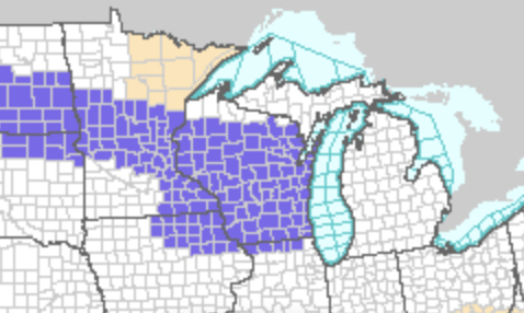
Looking like 3"-5" overnight and tomorrow. High end totals could push us out of even a top 20 least snowy winter. Crazy a winter this bad can look a little better than it seems when comparing to past duds. It is hard to imagine a winter with less snow than this but the historical record would say about 1 in every 6 has been this bad or worse.
-
The great plains are on whole different level when it comes to wind.
-
 1
1
-
-
On and off snow today that has dusted the ground a couple of times but melts as soon as it stops.
-
8 hours ago, TheClimateChanger said:
The so-called hottest summer on record was downright pleasant in Detroit outside of a single week. Even including the 7-day heat wave, it was a moderate summer and fairly mild by modern standards.
The mean temperature of 71.2F places 57th in the threaded record. In the past 9 years, only 2015 & 2023 have been cooler (and both by very small margins). By contrast, 2016 was nearly 4F warmer than 1936!
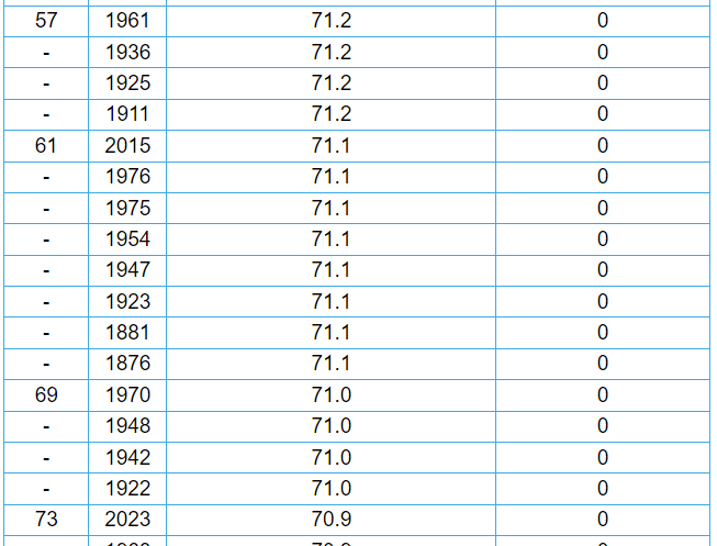
And to be honest, it makes much more sense to compare this to records observed at City Airport (DET) since that it was where the official temperatures were observed in 1936. On that metric, it was the 27th COLDEST summer out of 90 years of records.

Incredibly, removing one 7-day stretch would drop the summertime mean to 69.9F. I know you can't do this, but it gives a much better reading of the overall character of the summer. And that was one of low humidity and generally mild weather, with cool overnight lows, punctuated by a few episodes of extreme heat, including one colossal 7-day stretch in early to mid-July. At these levels, you'd be looking at the 12th coolest of 90 years at DET and 44th coolest of 150 years in the threaded Detroit area records.
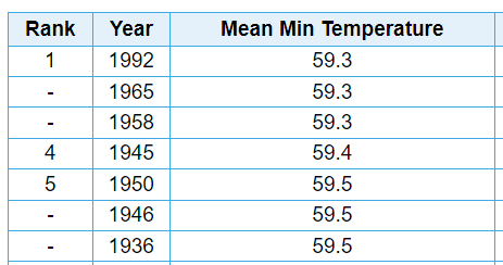
The 59.5F mean summer minimum is 5th lowest on record, out of 90 years' worth of observations at Detroit City Airport. That value has not been exceeded in recent decades since the volcanically cooled summer of 1992, and even then only by a negligible amount [59.3F]. In the threaded record, it's only 26th coldest of 150 years, as the coldest minima are dominated by the 1960s-1980s records from DTW when it radiated like a freezer at night [developed in low density suburb]. Still pretty cold either way. Ignoring the 7-day inferno [July 8-July 14], the mean minima the rest of the summer was just 58.4F, which would easily be the coldest on record at DET and would tie 1875 for 10th coldest in the threaded record.
Regarding the heat wave, you can pull up the old records and see the humidity and dry bulb temperatures at 3 periods each day. The mean dewpoint was probably around 55-55.5F, based on those observations. This is less than even the "frigid" July of 2009 when the average dewpoint at Detroit was a comfortable 56.3F. During the worst of the heat wave, humidity was generally very low. Under these conditions, the heat index would not greatly vary from the dry bulb temperature. Despite the extreme temperatures, there have been more dangerous conditions in recent summers when factoring in the cumulative effect of high dewpoints and temperatures. The most extreme heat indices in Detroit were experienced not in 1936, but in 1995, when triple digit temperatures were combined with dewpoints nearing 80F - rather than in the 50s.
The combination of generally moderate temperatures and very low humidity would have made the summer of 1936 more comfortable than the majority of recent summers in Detroit. If those same conditions repeated this year, and I tried to point out the upper 90s/100s as the result of climate change, you would no doubt change tune and attempt to rebut my assertion by going on about how cool and dry it was for the majority of the summer.
There is a subforum for this - https://www.americanwx.com/bb/forum/18-climate-change/ If every post you made wasn't 100% related to this subforum I wouldn't be complaining, but since that is all you do, take it over there will you.
-
 1
1
-
1
-
-
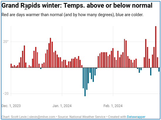
Mlive ran an interesting article recently. GRR had 15 days below normal for the entirety of met winter, MKG only had 12.
-
10 hours ago, OrdIowPitMsp said:
Wow. I’ve spent a lot of time in and around Monroe County during my 3 year stint in the oil and gas industry. Very rural, and borderline Appalachia feel to that part of Ohio, it’s a beautiful area. I lived out of the “Olive Tree Inn” in Woodsfield during winter 2014/2015 and experienced a massive snowstorm in the first few days of March. They got 12” in about 10 hours and all the roads were snowed in for a few days.
That is crazy you have been there. Not a lot of people can say they intentionally went to the Woodsfield area. I grew up just to the west of Monroe County in Noble County. That is indeed a beautiful part of Ohio and nothing like the area North of I-70 and West of I-71 which is what most people think of when they think of Ohio.
-
Michigan had a confirmed 2 tornadoes, one near Marshall the other near Grand Blanc.
-
1 hour ago, SolidIcewx said:
All you need is a dense fog statement and a flood statement
We had the dense fog earlier
-
Something is going to happen around here.
-
5
-
-
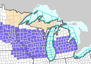
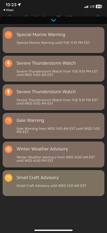
With all the severe weather talk, we just had a Winter Weather Advisory hoisted for late tonight into tomorrow. Talk about weather whiplash.
-
9 hours ago, DocATL said:
Yeah from an ENSO perspective I have no clue what’s good anymore. At this point, we might as well reap the benefits of an early spring. It appears March will be continuing the warm trend.Everyone is saying this, bu tliving in West Michigan this would most likely be an agricultural disaster like the Morch everyone keeps rooting for. Early blooms followed by a frost are very rough on this area so while I appreciate everyone's desire for warmth, please no.
-
Enjoy it. This may be your storm of the winter.
-
And with 5.5" reported at GRR yesterday the bottom 10 futility record is now in the rear view mirror. We are not sitting at #11 on the list going back to around 1900 or so.
-
We don't have MSP's totals, but it was definitely puking fatties on the way in to work this morning. Easily 1-2"+ diameter snowflakes. Too bad there was a little mixed precip thrown in.
-
20 minutes ago, madwx said:
will be right on the edge of accumulating snowfall tonight. Could easily get 3" or nothing.
same here
-
16 minutes ago, nwohweather said:
How there isn’t a thread for this storm is beyond me. Some serious snow on the models within 84 hoursStart one
-
2 hours ago, LibertyBell said:
He said this has been an amazing winter for the stratosphere, though the results have not always made it to ground level.
He is starting to sound like Bastardi
-
1
-
-
GRR is really questioning the Euro run
The ensemble mean of the upper air pattern has shown that the
streams do not split, and most of the energy slides across the
southern tier of the country, leaving the northern tier with a cool
and unsettled weather. The new 12z Euro deterministic run looks to
over-develop the upper system, which is a known bias of the Euro.
With this in mind, we will keep the cool temperatures in place for
next Monday, with low chances of showers.
-
12 hours ago, RogueWaves said:
New Years Eve. Yeah, surprisingly good score for DTW. Big month here as well with 31.7"
I never know where you are gong to pop up next. You sure do move around a lot. Welcome back to the GRR forecast area where you can be negelected almost as much as the Battle Creek area.
-
2
-
April 2024 General Discussion
in Lakes/Ohio Valley
Posted
Had a low of 39 today and 37 yesterday. Lake Michigan is helping out for sure.