

dwagner88
-
Posts
1,098 -
Joined
-
Last visited
Content Type
Profiles
Blogs
Forums
American Weather
Media Demo
Store
Gallery
Posts posted by dwagner88
-
-
At this point I’m looking for the fly in the ointment. I can’t help but notice robust convection originating in the gulf around 200 miles due south of the FL/AL border. It is persistent and appears unmoving. I’m wondering what affect it will have on moisture transport later if it doesn’t clear.
-
 1
1
-
-
There has been a trend this evening in showing a convective feature running along I-75 from Hamilton county up through Knox county. Wherever that sets up is in for quite a show from Mother Nature tonight. It reminds me of the MCV that formed in the February 2014 storm over Birmingham and travelled up the I-59 and I-75 corridors. I got around 4” additional snow (and some thunder) just from that feature during that event.
-
3
-
-
Just looked at the GFS. Almost had a stroke.
-
1
-
 1
1
-
-
Wow. 12Z NAM just took Chattanooga from 1” to 7”. Definitely more in line with other modeling. I’m still thinking 2-4” here. Tempering expectations. The mountains could certainly see 7”+. I’m about to go for a run in the 65 degree sunshine. 12 hours from now it should be dumping snow.
-
6
-
-
8 minutes ago, Wurbus said:
GFS absolutely clobbers the southern valley from Chatt to Lenoir City.
The GFS appears to be quite sensitive to the Eastman Chemical snow hole of despair. You can always see Kingsport.
-
2
-
-
4 hours ago, Runman292 said:
Just found this on MRX's website. Th3 critera is actually different based on location. The central and southern valley are in the 3" or greater zone, while the "horseshoe" counties are in the 4" or greater zone. That is the reason why NE TN is under an advisory and not a warning.
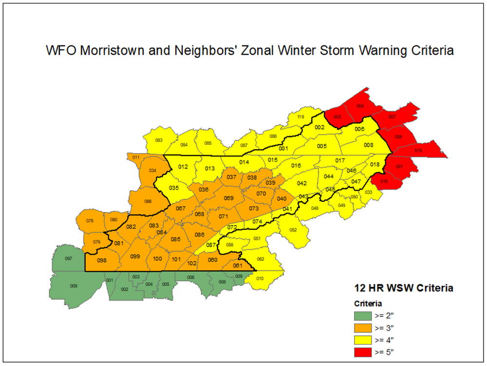
They finally implemented what I've been asking for! It never made sense to have the same warning criteria down here as Johnson City.
-
2
-
-
We have had a couple of events this winter advertise accumulations for 100% of the state. None have delivered so far. Is this “the chosen one”?
-
I’ll also add that the HRRR appears to show a dramatic improvement in BL temps throughout the southern valley on this run. 2.4” is the minimum over the UHI downtown on the river. Looks like most of Hamilton county is in the 3-4” range. That would be fantastic. As bad as the last two years were, I would settle for enough to cover the grass.
-
2
-
-
I’m secretly overjoyed that 99% of NC misses out on this. I’ll consider it reverse CAD.
-
1
-
4
-
-
6 minutes ago, John1122 said:
The mean is 4 inches for Memphis, 5 for Nashville and Knoxville. Each have a few 10+ inch big hitters. Nashville had a 15 incher.
Held steady here with 3.37”. In an encouraging change, zero members show a total shutout. One only has 0.25” or so. Big dog here is around 9”.
-
2
-
-
I’m honestly a little surprised at the winter storm watch. I expected the typical valley winter product black hole. I think that indicates they are at least considering a higher end event, even down here.
-
4
-
-
3 minutes ago, PowellVolz said:
Yesterday it looked good. Has anyone seen it today?
.Looks a lot like the Euro cut in half to me.
-
1
-
-
Just now, Wurbus said:
I'm sure they have some "in house" model they can use.
They seem to rely heavily on the NBM. It also tends to be the most conservative model.
-
1
-
-
18 minutes ago, Holston_River_Rambler said:
That's ideal. I want to be stuck in Boone for 3 - 4 weeks. I will be at the base of Grandfather mountain and want to have to march up to the summit to see any hope of rescue from the HISTORIC snow drifts that approach the swinging bridge. Hopefully the NWS will have to invent a new warning criterium for what I will experience. Ultra Blizzard Warning, colored black like the color my flesh would be after only minutes out of doors unprepared. I want to see the tears of those who dread snow and ice to freeze as the flow down their frostbiten faces. They'll have to rename the month of March "Snow," it will be so historic, so dreadful, so cold, so snowy. Roads will be impassable and antifreeze frozen. Spring Break will be a mere legend, a long forgotten dream in the hearts of children, covered like the daffodils and redbuds in feet of icy cement. I want to read a NWS forecast discussion with words like "isothermal," and phrases like "quasigeostropic forcing out the wazoo," "frontogentic mesoscale banding," and "isentropic upthrust." The lifting mechanisms need to be compared to geologic forces, but playing out in meteorological time scales.
Heavy. At. Times.

I'd like to subscribe to your newsletter.
-
1
-
-
9 minutes ago, Hurricaneguy said:
Out of curiosity does anyone remember the last decent snow in March for East TN? I’m having trouble remembering one in recent years.
I had two small events in March 2009.
-
1
-
 1
1
-
-
I see more heartbreak for Chattanooga. Haven’t we suffered enough this winter? At least we didn’t lose any storms to northern Florida this year.
-
2
-
-
4 hours ago, nrgjeff said:
And NO FF WARNING! Two blocks away in Georgia was warned. Hamilton Co. only an advisory. @dwagner88 is that right or did I miss the warning?
Every way out of East Brainerd to the Interstater was flooded. However Hamilton Co. schools and private schools business as usual. The one morning we needed a 2-hour delay, nothing was done. This after 4-5 false school closures.
Is that on the schools? I would say it's on the NWS. Today was a colossal failure of the warnings system. Mike Smith (infamous on Twitter) mode activated. We need an independent review board!
I'm trying to figure out a diplomatic way to email NWS from work. I can't find professional wording at this time.
You didn't miss anything. The only schools that delayed were those on Signal mountain. SR-8 (main hwy up) was closed due to debris from storm flows for a few hours this morning. At one point my employer had full or partial closures on 10 different state routes. I'm sure the local and county roads were even worse.
-
1
-
-
Flooding problems area wide this morning. Probably the worst since the March 2020 tornado night.
-
1
-
 1
1
-
-
I just signed a contract on a new house. I’m moving out to Apison. The house sits at around 950’ in elevation on the back side of White Oak Mountain. It should do much better in winter events than my current house in the city at 780’.
-
11
-
-
2 hours ago, Stovepipe said:
That was a really fun event. Robert nailed it.
Only time in my life I had to abandon my car and walk home. And it only snowed a little over an inch. This was the infamous Atlanta snowpocalypse.
-
Concerned about the GFS sniffing out flooding. This is the timeframe. It’s been a running tradition for 3 years now I think.
-
2
-
1
-
-
According to the wundermap it’s 64 here and 34 on Monteagle. That’s a 30 degree difference over about 40 miles.
-
1
-
-
1 hour ago, Shocker0 said:
Yes, February 21, 2015 here in Crossville we had an inch plus of freezing rain. It looked like a tornado came through in places with the high winds on top of it. Hopefully they will somehow get lucky out west with it not being as bad. Almost all of Crossville that could afford to, went to stay in hotels in Cookeville (barely any ice there and all the hotels there quickly became booked up too). The hotels also charged much higher rates than normal due to the influx from the storm.
Then, A few days later when everything started clearing up many people tried returning to Crossville. I-40 was shut down for a bit while powerlines were restored in Monterey so people weary from the ice storm all went to the shoulder to try to exit since the exit ramp was right there, and State Troopers went down the shoulder writing tickets to everyone for doing so. It added insult to injury after the ice storm when people had lost all their food and who knows what else.


I was happy to miss this one. It was 33-34 with rain the entire time here. Then we got a beautiful miller A with 8-10" of snow area wide right after.
-
1
-
1
-
-
There is a very heavy slug of moisture that is going to lay down some accumulation just south of Chattanooga across Ne Alabama and NW Georgia. What a miserable winter this has been.
-
2
-

March 11th-13th Winter Weather Event. Winter's last gasp?
in Tennessee Valley
Posted
Sadly it appears oriented due E-W right now.