

dwagner88
-
Posts
1,098 -
Joined
-
Last visited
Content Type
Profiles
Blogs
Forums
American Weather
Media Demo
Store
Gallery
Posts posted by dwagner88
-
-
6 minutes ago, PowellVolz said:
Is the mixing at the end of the event when we start to lose rates?
.I'm not sure. I didn't look at the hourly frames. But I did notice a couple of things. The accumulations shot further down into north AL and GA, but they clearly aren't all snow. The difference between the 10:1 and Kuchera is too much. I think it's sleet. I also think it's kinda pointless to look at it at such a fine grained level. There will be a warm nose somewhere, but there's no way the models are going to nail that down precisely. I still think the arctic air wins out and the sleet is minimal.
-
 1
1
-
-
1 minute ago, Chattownsnow said:
Looks like it came in a little lighter on total QPF. Basically noise at this point I suppose but worth noting. The short range models are mostly holding serve if not beefing up QPF slightly as the event closes in.
.It's also mixing down here. Kuchera is lower than 10:1.
-
1
-
-
Not sure what algorithm the Carrot weather app uses, but I woke up to a forecast of 10” of snow from it this morning. Not ending until Wednesday. I don’t put much stock in that, but it is interesting to see.
-
2
-
-
1 minute ago, John1122 said:
The Euro basically stayed the same. It's on the southern edge of guidance still with the NAM on the northern. Everything else is basically in the middle of both. It keeps the narrow snow footprint.
It appears to have given my area a little more buffer to the southern edge. It got more of northern GA this time.
-
1
-
-
This is probably the best shot at subzero temps in Chattanooga in my life. If we get the good snow cover shown on many of the globals, we have a real shot at it. I don't think it has happened since January 1985 (-10 and the all time record). I was born in 1988.
-
5
-
-
2 minutes ago, Silas Lang said:
Latest ICON
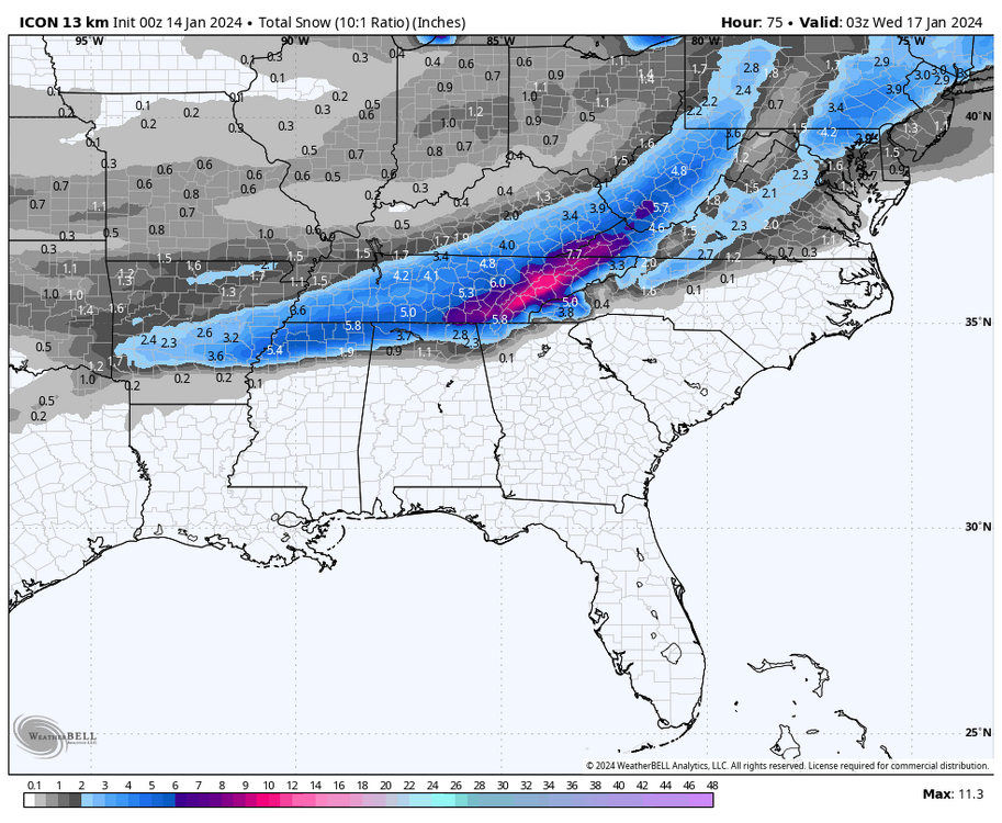
Trowal? Definitely some enhancement along I-75 there.
-
3
-
-
The NAM's tendency to over amp things may be contributing to the valley p-type issues. Arctic air push is also frequently under modeled. It's dense. It should spill right in. It could be right, but I'm not as worried since it is on an island right now.
-
3
-
-
Man I really don't know what to think down here. The globals are all game on. The short range models do not like this entire corner of the state.
-
2
-
-
1 hour ago, BhamParker said:
Just booked a cabin in Gatlinburg from tomorrow until Wednesday! Looking forward to this storm.
.Oddly, you might actually be better off in a hotel in Knoxville for this one. It's a strange storm.
-
1
-
-
16 minutes ago, ShawnEastTN said:
Agree especially considering portions of Hamilton county is consistently 3" or higher even if chatty isn't.
Sent from my Pixel 7 using Tapatalk
Historically, MRX considers Hamilton county to mean Chattanooga. They won't issue advisories or warnings if the event only affects Lookout and Signal mountains for example. I don't see them doing anything differently this time.
-
2
-
-
1 minute ago, TellicoWx said:
Think it will be I-40 and north for the valley, all plateau/mountains. They will probably hold off on Southern valley unless there is some changes across all the models.
They would be foolish to leave out Meigs and Rhea at this point. That just leaves the southern border counties. I wish I could say I've never seen that before, but sadly I have.
-
2
-
-
Sadly, I think MRX will go with WSW for the entire CWA except Hamilton, Bradley, and Polk Counties. I think this one is going to be quite painful for SE TN snow lovers to watch. Likely to be the only area in the state shut out.
-
3
-
-
An impossible forecast for here. Nothing at all in my corner of the county. 4" in the northern portions of Hamilton.
-
2
-
-
22 minutes ago, Carvers Gap said:
Let me edit my last comment....Chattanooga is oddly in the best place to score 1-2" of snow on that run.
Take some comfort in the knowledge that this has got to be the least likely eventual outcome based on past history.
-
3
-
 1
1
-
-
Pretty good dusting on Signal this morning. I had some sleet pellets in the valley of my roof. But I did get up to see the first flakes of the season fall. They are very late this year.
-
1
-
-
Tons of flooding this morning. We may crack 4" from this system. I can't believe we don't even have a flood advisory out. It's borderline FFW conditions here.
-
1
-
-
6 hours ago, WinterWonderland said:
I live in Anderson County, TN in Oak Ridge and the snow we had in Feb 1996 was incredible. One of the best I've seen in my life time and I'm 68 yrs old. With that particular storm, the mets were not predicting snow, but heavy ice. In inches. The thought of it icing that much was scary. That evening it started sleeting and 30 min later changed to all snow and stayed snow. Never had any ice thank goodness. Here in town we got about 18 inches and I have never seen snow fall that heavily, and straight down cause there was no wind. Businesses closed and people were walking instead of driving. The streets were literally snow packed and it snowed off and on for two weeks. We did a LOT of sledding! Anyway, sorry to be so long with my post, but it truly was a magical time. I even journaled it and glad I did! I just wished I'd gotten some pics!
Sent from my Pixel 3 using Tapatalk
I can't remember if it was the Feb storm or the big Jan 96 blizzard, but one of those storms gave us almost 6" of sleet down here. It was like a marble countertop everywhere. Absurd sledding. MRX is missing KCHA ASOS data from that winter, so I can't look up when it actually happened.
-
2
-
-
Hwy 111 between Soddy Daisy and Dunlap will be a good spot this weekend. It gets up to around 2300' and is all controlled access freeway. There are a few spots along the ridgetops that always seem to have snow showers when the wind is blowing the right direction, even if they don't show up on radar.
-
1
-
-
Jeez. We cleared over 2" with this system. It rained HARD yesterday. Sorry NE guys missed out.
-
6
-
-
On 12/18/2023 at 10:16 AM, PowellVolz said:
I just want a stress free snow, just once. No warm nose, no boundary layer issues, no 500 mile track swings, etc… give me mid to upper 20’s surface temps and a phasing GOM low pressure. I’m not asking for too much am I?
.Early January 2011 overrunning event. Only time in my life there was a stress free snow. Zero modeling had us getting missed, and temps were in the low 20's when it started. The models had that one keyed in from 7 days out. Even the superstorm was in doubt by many. February 2015 was close to stress free, but not as certain via modeling.
-
3
-
-
1 hour ago, Carvers Gap said:
And I am not going to be track this for two weeks(feel free to if you want...I won't judge!), but modeling is picking up on a storm signal around the 28th or 29th. You can see it every so slightly in the GEPS/GEFS individual snow maps at 12z. The actual low placement you can see pretty clearly on ensembles...but there is a bit of a signal now at the surface. As one of the guys mentioned in the MA thread, the actual shift at 500 may end-up only missing by about 5 days. As Boone noted and also LC, our cold maybe well come from successive storms which steadily press the bound ward eastward, and then tap that cold in eastern Canada. Again, that is a decent storm signal, and does work given the set-up which Boone mentioned above.
Seems like there is one every year around that time. We've had many years in the past with either winter threats, flooding, or severe weather.
-
2
-
-
Overperformed this rain event also. 2.36” in the bucket since Friday morning. Nearly 5” in the past 10 days. That’s awesome. Maybe El Niño is finally reverting to type.
-
5
-
-
3 hours ago, PowellVolz said:
Low temps in, around Knoxville didn’t get close to projected temps this week.
.I even managed 19 down here yesterday. That's odd for TYS.
-
2
-
-
We actually overperformed this rain event. 1.80" IMBY. KCHA really cashed in with 2.60". We needed that.
-
6
-
January 15th-17th 2024 Arctic Blast/Snow Event
in Tennessee Valley
Posted
FWIW my temp is completely stalled at 44 DP 30 for the past 2 hours. Not sure the CF is making much progress. That may lend more credence to the NAM. I'm in a really bad spot for this one though. Almost as far SE as you can get in Hamilton county.