Weatherdemon
-
Posts
401 -
Joined
-
Last visited
Content Type
Profiles
Blogs
Forums
American Weather
Media Demo
Store
Gallery
Everything posted by Weatherdemon
-
MO/KS/AR/OK 2019-2020 Winter Wonderland Discussion
Weatherdemon replied to JoMo's topic in Central/Western States
Not much change on 12z v3 and GFS.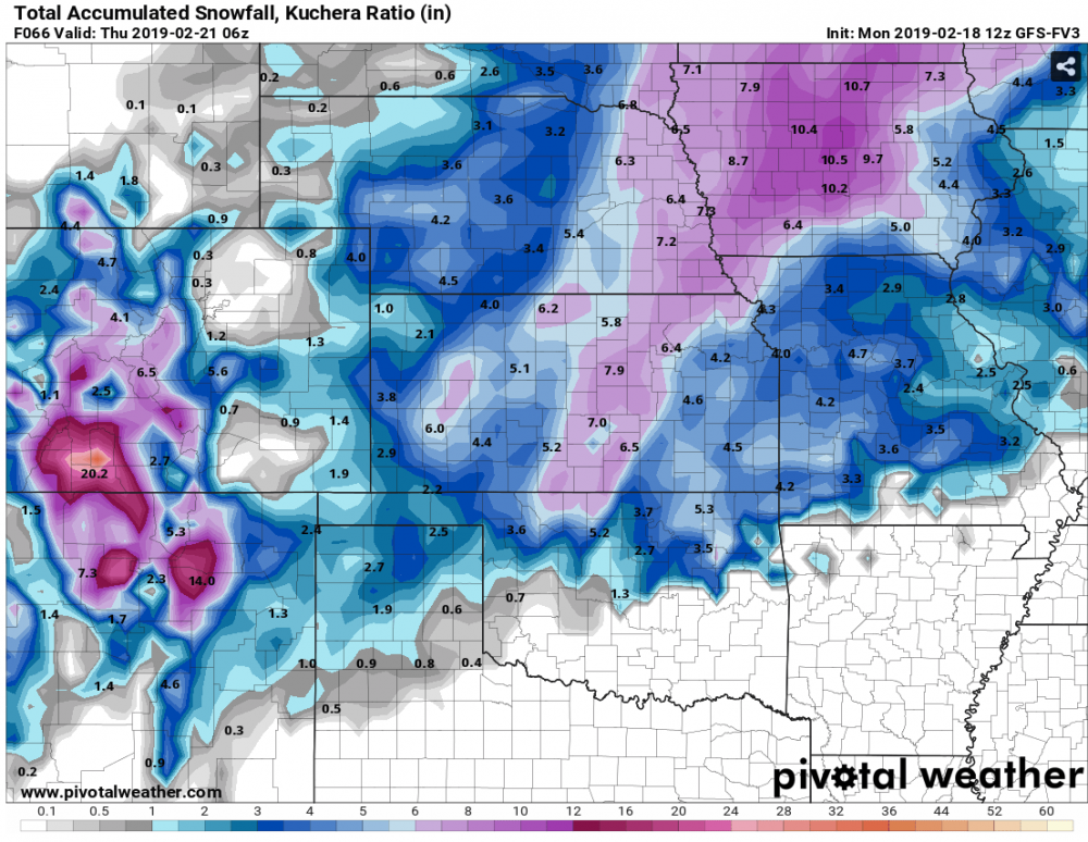

-
MO/KS/AR/OK 2019-2020 Winter Wonderland Discussion
Weatherdemon replied to JoMo's topic in Central/Western States
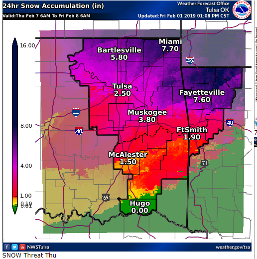
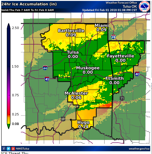
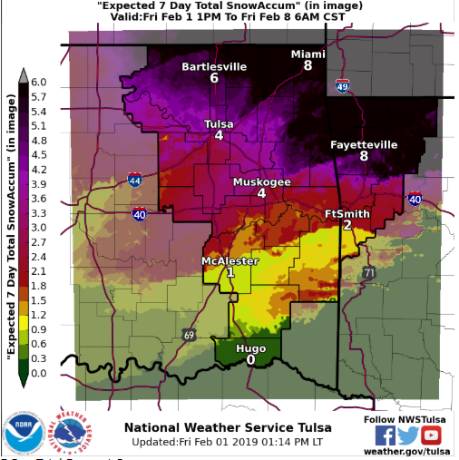
Tulsa NWS seems like its going with the GF/v3 on QPF and they seem to like more sleet than snow. NAM/3K/Euro show lower QPF but, Euro shows more snow. I'm thinking the Euro snow amounts include sleet and don't have the right ratios even with the lower QPF. Anyone who thinks forecasting is easy should look at this NWS map, LOL.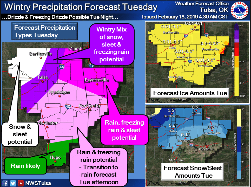
-
MO/KS/AR/OK 2019-2020 Winter Wonderland Discussion
Weatherdemon replied to JoMo's topic in Central/Western States
They have to. Especially the OKC guys with the higher potential in their area. -
MO/KS/AR/OK 2019-2020 Winter Wonderland Discussion
Weatherdemon replied to JoMo's topic in Central/Western States
You were right! They expanded it south one county. Its 2-3 degrees colder than expected too. Bartlesville schools closed. Sleet mixed in as far S as Owasso. Sleet in Owasso is very light and very small though. Elevates surfaces glazed here too. At 29-30 degrees right now, we’re close to roads icing. 2-3 degree drop and it would be ugly. -
MO/KS/AR/OK 2019-2020 Winter Wonderland Discussion
Weatherdemon replied to JoMo's topic in Central/Western States
...WINTER WEATHER ADVISORY IN EFFECT FROM 5 AM TO 6 PM CST FRIDAY... Benton-Carroll-Osage-Washington OK-Nowata-Craig-Ottawa-Pawnee- Tulsa-Rogers-Mayes-Delaware-Creek- Including the cities of Rogers, Bentonville, Berryville, Eureka Springs, Pawhuska, Bartlesville, Nowata, Vinita, Miami, Pawnee, Tulsa, Claremore, Pryor, Grove, Jay, and Sapulpa 226 PM CST Thu Feb 14 2019 * WHAT...A mixture of freezing rain and sleet is expected beginning late tonight through the day Friday. Total sleet accumulations of a few tenths of an inch, and ice accumulations of a light glaze to near a tenth of an inch are expected. * WHERE...Portions of northeast Oklahoma and northwest Arkansas generally along and north of a line from Tulsa Oklahoma to Bentonville Arkansas. * WHEN...From 5 AM to 6 PM CST Friday. * ADDITIONAL DETAILS...Plan on slippery road conditions, including during the morning commute on Friday across northeast Oklahoma. Bridges and overpasses will be the first to be impacted by any slick surfaces. -
MO/KS/AR/OK 2019-2020 Winter Wonderland Discussion
Weatherdemon replied to JoMo's topic in Central/Western States
Friday morning looks interesting in N OK. NAM shows .34 in total liquid precip but has most of that as freezing rain or sleet. Tulsa NWS says NAM temps may be too warm as it warms above freezing after noon. 3K has .14 liquid equivalent and all of it freezing rain or sleet and keeps temps dropping all day. GFS at .11 with all of it freezing rain or sleet N of I244. It doesn’t have the cold air as far S. GFS showed this system I think on Monday as all snow then dropped it. V3 keeps measurable precip east of HWY 69 with trace amounts of freezing rain. It is further N with cold air than the GFS too. -
MO/KS/AR/OK 2019-2020 Winter Wonderland Discussion
Weatherdemon replied to JoMo's topic in Central/Western States
00z control dumps on OK. Got some lightning and thunder in the meantime -
MO/KS/AR/OK 2019-2020 Winter Wonderland Discussion
Weatherdemon replied to JoMo's topic in Central/Western States
Yea! Sticking a little here too! -
MO/KS/AR/OK 2019-2020 Winter Wonderland Discussion
Weatherdemon replied to JoMo's topic in Central/Western States
Enough ice to freeze windshields and car doors. Enough flurries to put a very light dusting of snow down. What a waste of another system. N of here got .25 or more of ice. -
MO/KS/AR/OK 2019-2020 Winter Wonderland Discussion
Weatherdemon replied to JoMo's topic in Central/Western States
Interesting radar earlier tonight N of OKC.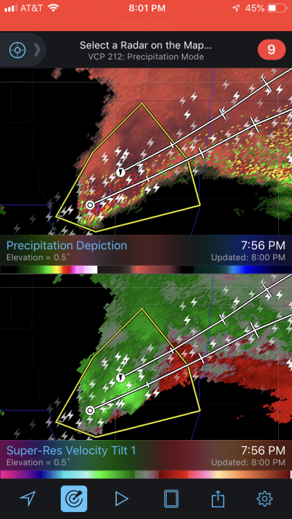
-
MO/KS/AR/OK 2019-2020 Winter Wonderland Discussion
Weatherdemon replied to JoMo's topic in Central/Western States
Looks like a chance of freezing drizzle Tuesday night/Wed morning. Worse kind of precip at the worse time in terms of roads. -
MO/KS/AR/OK 2019-2020 Winter Wonderland Discussion
Weatherdemon replied to JoMo's topic in Central/Western States
V3 coming in with ice for SE OK. I’m kind of liking having one N and one S. maybe they’ll meet in the middle! -
MO/KS/AR/OK 2019-2020 Winter Wonderland Discussion
Weatherdemon replied to JoMo's topic in Central/Western States
Looks like 3 potential systems Thurs-Sun on this run. Shallow cold air going to make things interesting. Knowing this season, we’ll be 33 and get 2 inches of rain, LOL. -
MO/KS/AR/OK 2019-2020 Winter Wonderland Discussion
Weatherdemon replied to JoMo's topic in Central/Western States
V3 does except it puts some some decent snow N of I44. Hammers NE TX with ice though. -
MO/KS/AR/OK 2019-2020 Winter Wonderland Discussion
Weatherdemon replied to JoMo's topic in Central/Western States
00z GFS siding towards Euro -
MO/KS/AR/OK 2019-2020 Winter Wonderland Discussion
Weatherdemon replied to JoMo's topic in Central/Western States
Fair statements considering their performance this year. They pulled their chiclet snow totals down to 1/3 inch of snow. “Still some significant differences in the operational models concerning strong upper level storm system that will impact the region Thursday into Friday. Generally trended toward the more compact and progressive ECMWF solution that sweeps strong cold front through the area on Thursday. With this scenario, overall winter weather potential would remain limited as showers/thunderstorms move east before the colder air moves in behind front.” -
MO/KS/AR/OK 2019-2020 Winter Wonderland Discussion
Weatherdemon replied to JoMo's topic in Central/Western States
-
MO/KS/AR/OK 2019-2020 Winter Wonderland Discussion
Weatherdemon replied to JoMo's topic in Central/Western States
Interesting. Sleet should be closer to 3. Good to know on that model. Thanks! -
MO/KS/AR/OK 2019-2020 Winter Wonderland Discussion
Weatherdemon replied to JoMo's topic in Central/Western States
2.5 inches of liquid so I would say mostly snow. Freezing rain-->Sleet-->then Snow -
MO/KS/AR/OK 2019-2020 Winter Wonderland Discussion
Weatherdemon replied to JoMo's topic in Central/Western States
That would pretty much shut everything down. Not sure I want that but, I certainly freaking want something exciting this winter! -
MO/KS/AR/OK 2019-2020 Winter Wonderland Discussion
Weatherdemon replied to JoMo's topic in Central/Western States
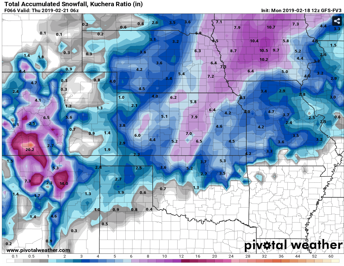
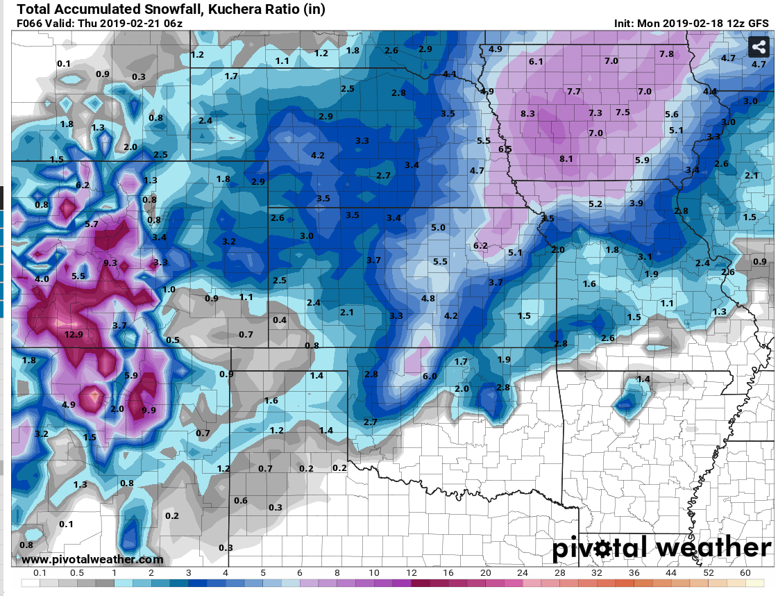
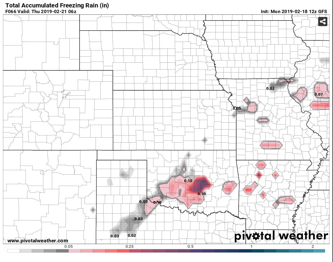
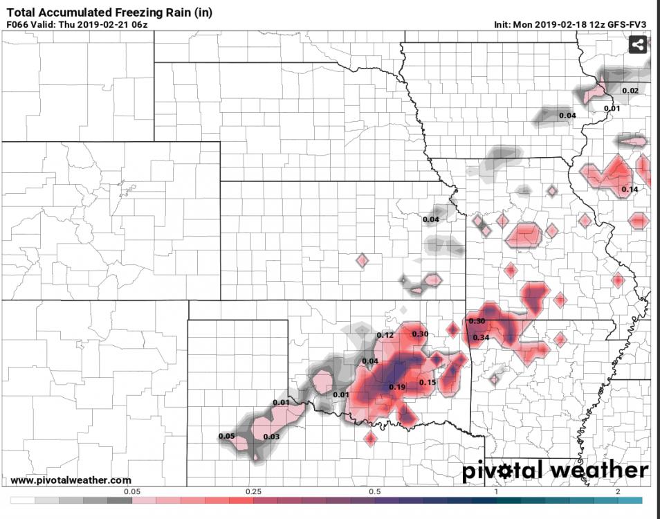
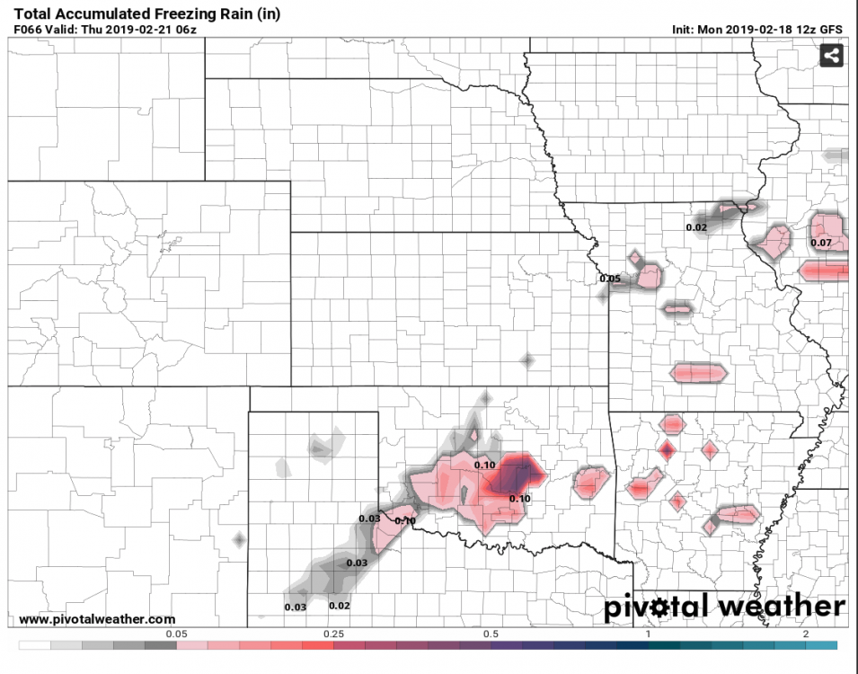
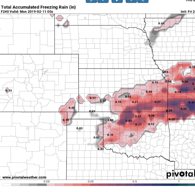
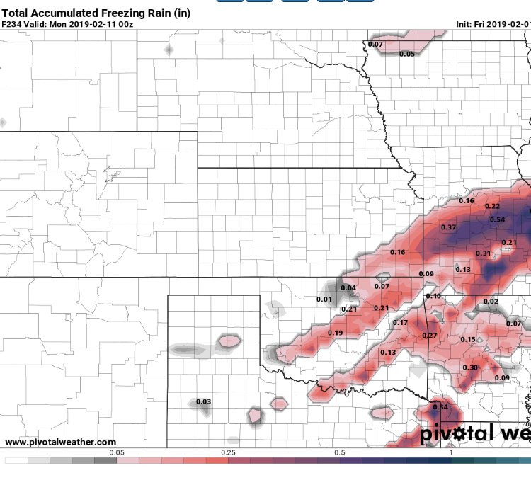
00z GFS more progressive with ice NW and S of NE OK. 00z V3 with enough ice to cause issues. 06z slower with significant ice. 06z V3 looking close to 00z. Euro brings system through fast with moisture gone before air makes in through. GFS and V3 images below. 06z GFS, 00z then 06z V3.
-
MO/KS/AR/OK 2019-2020 Winter Wonderland Discussion
Weatherdemon replied to JoMo's topic in Central/Western States
18z GFS similiar... Another storm to crush our hopes by Monday. -
MO/KS/AR/OK 2019-2020 Winter Wonderland Discussion
Weatherdemon replied to JoMo's topic in Central/Western States
It took about 30 minutes for the lower levels to saturate enough to get snow to the ground here. -
MO/KS/AR/OK 2019-2020 Winter Wonderland Discussion
Weatherdemon replied to JoMo's topic in Central/Western States
It fell fast enough to make my neighborhood road mostly white from a pic my wife sent. Made some elevated surfaces white in downtown Tulsa. Was fun walking back from lunch with some snow! -
MO/KS/AR/OK 2019-2020 Winter Wonderland Discussion
Weatherdemon replied to JoMo's topic in Central/Western States
Yep. They extended the WWA a couple of hours and expanded it then cancelled it about 30 minutes early. Models don't show anything as far out as I can see. Since forecast events dies off within a couple of days of occurrence, can we not get a modeled non-event to turn into a surprise 3-4 inches?