Weatherdemon
-
Posts
401 -
Joined
-
Last visited
Content Type
Profiles
Blogs
Forums
American Weather
Media Demo
Store
Gallery
Everything posted by Weatherdemon
-
MO/KS/AR/OK 2020-2021 "Winter" Discussion
Weatherdemon replied to JoMo's topic in Central/Western States
0z HRRR through storm 1.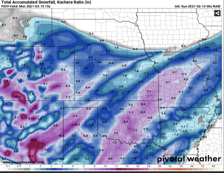
-
MO/KS/AR/OK 2020-2021 "Winter" Discussion
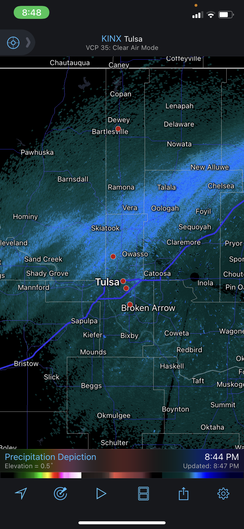
Weatherdemon replied to JoMo's topic in Central/Western States
Looks like legit returns.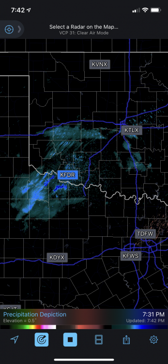
-
MO/KS/AR/OK 2020-2021 "Winter" Discussion
Weatherdemon replied to JoMo's topic in Central/Western States
From Norman NWS... The snow associated with the main storm system will move into the area Sunday morning near or just before sunrise Sunday morning. In general, the model QPF is a little lower than previous forecasts, so have adjusted the snow amounts down just a touch. We are still expecting amounts of 5 inches or more throughout the forecast area, with the highest amounts of roughly 8 to 9 inches across southwest Oklahoma and area of north Texas near Wichita Falls. The storm system looks a little quicker and have adjusted the timing of the forecast and heaviest snowfall a little bit. -
MO/KS/AR/OK 2020-2021 "Winter" Discussion
Weatherdemon replied to JoMo's topic in Central/Western States
That was actually from COD. -
MO/KS/AR/OK 2020-2021 "Winter" Discussion
Weatherdemon replied to JoMo's topic in Central/Western States
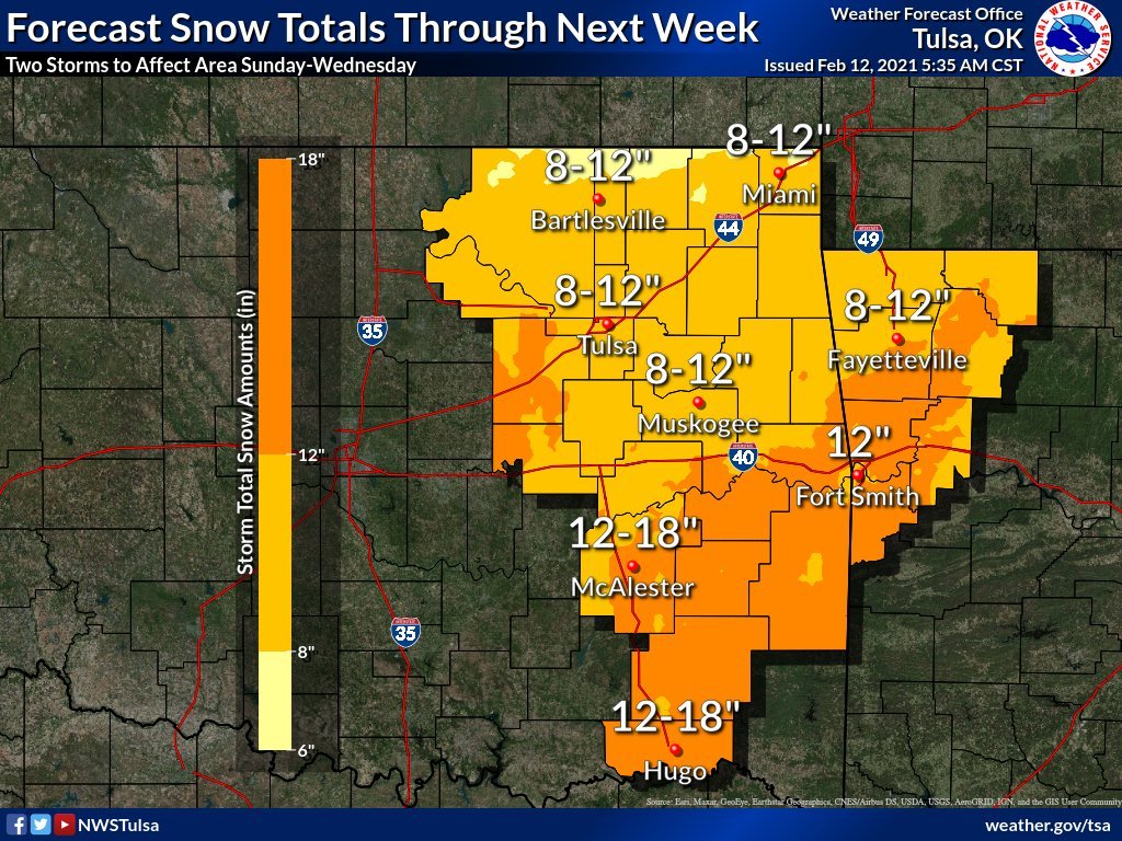
NAM3K throws down 16 in OKC -
MO/KS/AR/OK 2020-2021 "Winter" Discussion
Weatherdemon replied to JoMo's topic in Central/Western States
Tulsa NWS mentioning thunder snow in the first band... Area Forecast Discussion National Weather Service Tulsa OK 148 PM CST Sat Feb 13 2021 .DISCUSSION... The deepening and drying arctic air mass has resulted in an end to the flurries for the most part as well as the lake effect snow. There are reported sightings of the star about 92 million miles away from us. Some folks call it the sun. All I know is it's nice to see. This appearance will be brief. We're expecting the onset of the much talked about winter storm to be after midnight tonight. CAM guidance is keying in on a frontogenetic band setting up close to the I-44 corridor to the north of the 850mb frontal zone, where locally heavy snows are likely. The narrower and more intense nature of the band depicted in the CAMs suggest some CSI and maybe a rumble of thunder. This band will gradually shift east thru the day Sunday and weaken while another band along the 700mb frontal zone advances WNW to ESE across the entire region Sunday afternoon and night. The event comes to a rather quick end Monday. The upper system is expected to remain more of an open wave with the bulk of the forcing and QPF with the upper system itself to stay just to the south and east of the forecast area. This has resulted in an overall reduction in snow amounts over portions of northwest Arkansas and southeast Oklahoma. Nevertheless, expected amounts are at least close to warning criteria, then you combine that with the high impact to travel from blowing and drifting snow and the dangerous wind chills. The next system will follow quickly on its heels Tuesday night into Wednesday. There is still quite a bit of uncertainty regarding some important details. The GFS is painting the picture of an epic snowstorm for our area, while the EC is not. There are significant differences in the amount of QPF that will fall over our area. Will continue the theme of the previous forecast with the heavier snow potential south of I-40. Bottom line, this system has the potential to be a high impact to travel, but uncertainties in the details still exist so don't get too hung up on amounts at this point. A warming trend will start in the wake of this system toward the end of the week on into next weekend, slowed i -
MO/KS/AR/OK 2020-2021 "Winter" Discussion
Weatherdemon replied to JoMo's topic in Central/Western States
18z HRRR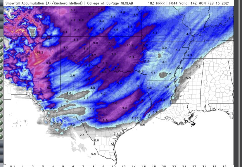
-
MO/KS/AR/OK 2020-2021 "Winter" Discussion
Weatherdemon replied to JoMo's topic in Central/Western States
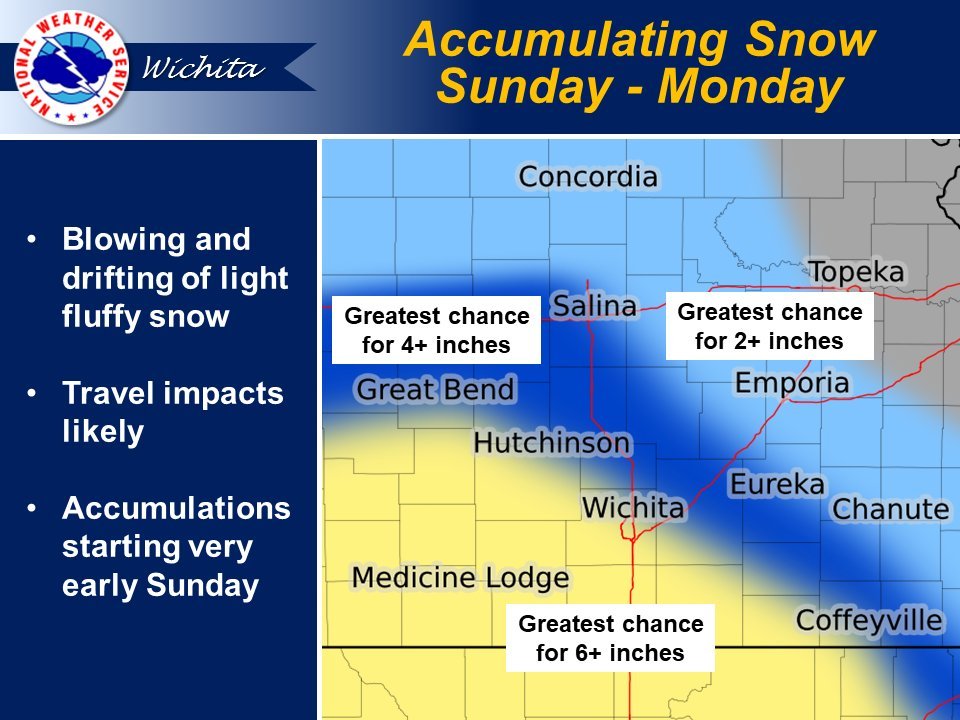
Tulsa NWS HWO 128 PM CST Sat Feb 13 2021 This Outlook is for Northwest and West Central Arkansas as well as much of Eastern Oklahoma. .DAY ONE...Today and Tonight. WINTER WEATHER. SNOW ACCUMULATION. RISK...Limited. AREA... Northeast Oklahoma. ONSET... After Midnight. Additional Accumulations in Later Periods. WIND CHILL. RISK...Significant. AREA... Northeastern Oklahoma and northwestern Arkansas. ONSET... After Midnight. DISCUSSION... With the sun coming out this afternoon, it has helped reduce the sting of the wind chills but it still remains very cold across eastern Oklahoma and northwestern Arkansas. With temperatures warming across eastern Oklahoma, the Wind Chill advisory will be cancelled early. The wind chill advisory will remain in effect across northwestern Arkansas. Dangerous wind chills will move in once again late tonight into early tomorrow morning in tandem with our winter storm system. Wind chill values may drop as low as 15 below zero across northeast Oklahoma and 10 below zero across northwestern Arkansas. As for the wintry precipitation, we are expecting a lead band to develop ahead of the main wave of snow late tonight into early tomorrow morning. There are still some questions into exactly where this band sets up but locations within this lead band will experience heavy snowfall rates likely exceeding 1 inch per hour at times. This particular band and its development will need to be watched closely as this could greatly affect snowfall totals. SPOTTER AND EMERGENCY MANAGEMENT ACTION STATEMENT... Spotter Activation Not Expected. .DAYS TWO THROUGH SEVEN...Sunday through Friday. SUNDAY...Winter Weather Potential...High Wind Potential...Dangerous Wind Chill Potential. MONDAY THROUGH THURSDAY...Winter Weather Potential...Dangerous Wind Chill Potential. FRIDAY...Dangerous Wind Chill Potential. EXTENDED DISCUSSION... Light to moderate snow will likely be ongoing Sunday morning across portions of the area, and both areal coverage and intensity should increase during the day and into Sunday night. The snow potential will decrease from west to east Monday, ending by Monday afternoon. Average storm total snowfall from 3 to 8 inches is currently forecast, with the higher end amounts favored in parts of northeastern Oklahoma generally along and near interstate 44 with lower amounts favored across far southeastern Oklahoma and west-central Arkansas. Locally higher amounts can be expected, especially for locations within the locally heavy snow band expected to develop late tonight into early tomorrow morning. Northerly winds gusting in the 20 to 25 mph range will combine with the dry nature of the snow to lead to considerable blowing and drifting snow. Significantly reduced visibilities can be expected. Travel will be difficult if not impossible at times. A second winter storm continues to look likely to bring additional significant snow to eastern Oklahoma and northwest Arkansas Tuesday night and into Wednesday. At this time, it appears that areas along and south of Interstate 40 will be more favored for higher snow totals than areas farther north. However, the location and accumulation details associated with this event contain more uncertainty than with the first storm, and as such, fine tuning can be expected over the coming days. In addition to the impactful snows, dangerous and life-threatening wind chills will continue Sunday and through most of next week. Conditions will worsen significantly Sunday and into the early part of next week, as wind chills drop well below zero areawide. Wind chills will be lowest Monday morning when most of eastern Oklahoma and far northwestern Arkansas will see values at or below 20 below zero with isolated locations nearing 30 below zero across northeast Oklahoma. -
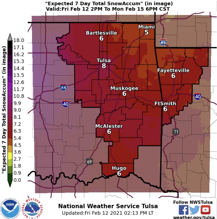
MO/KS/AR/OK 2020-2021 "Winter" Discussion
Weatherdemon replied to JoMo's topic in Central/Western States
Tulsa NWS thinking 6 for round 1 and 7 for round 2 in Tulsa.
-
MO/KS/AR/OK 2020-2021 "Winter" Discussion
Weatherdemon replied to JoMo's topic in Central/Western States
I meant inconsistency consistently. I’m talking GFS for over a week, the ICON, then the Euro then... Like I said though, it’s been an over-performing several days so I remain hopeful. -
MO/KS/AR/OK 2020-2021 "Winter" Discussion
Weatherdemon replied to JoMo's topic in Central/Western States
Man, It is frustrating that the “next” storm is always the “one”. If we get 5-10 total here, I’ll be happy. But, some much inconsistency so consistently killed at the end just sucks. Everyday has over-performed for over a week so, I remain hopeful! -
MO/KS/AR/OK 2020-2021 "Winter" Discussion
Weatherdemon replied to JoMo's topic in Central/Western States
Didn’t expect this... Already have a dusting.
-
MO/KS/AR/OK 2020-2021 "Winter" Discussion
Weatherdemon replied to JoMo's topic in Central/Western States
There has been. Depends on wind speeds. Last I saw we were about 5MPH under on the forecast winds. -
MO/KS/AR/OK 2020-2021 "Winter" Discussion
Weatherdemon replied to JoMo's topic in Central/Western States
Me likey!!!! -
MO/KS/AR/OK 2020-2021 "Winter" Discussion
Weatherdemon replied to JoMo's topic in Central/Western States
18z GFS slight better for NE/E OK but worse for SW OK for storm 1.
-
MO/KS/AR/OK 2020-2021 "Winter" Discussion
Weatherdemon replied to JoMo's topic in Central/Western States
You’re correct. I didn’t realize that. 10.3 is the week. 6.8 is Sat-Mon -
MO/KS/AR/OK 2020-2021 "Winter" Discussion
Weatherdemon replied to JoMo's topic in Central/Western States
Tulsa NWS still pulling back on amounts.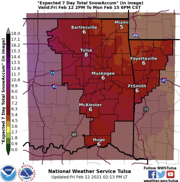
-
MO/KS/AR/OK 2020-2021 "Winter" Discussion
Weatherdemon replied to JoMo's topic in Central/Western States
Most of the other CAMS show this initial band as well. -
MO/KS/AR/OK 2020-2021 "Winter" Discussion
Weatherdemon replied to JoMo's topic in Central/Western States
-
MO/KS/AR/OK 2020-2021 "Winter" Discussion
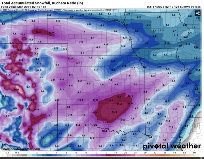
Weatherdemon replied to JoMo's topic in Central/Western States
Euro feeling generous. -
MO/KS/AR/OK 2020-2021 "Winter" Discussion
Weatherdemon replied to JoMo's topic in Central/Western States
-
MO/KS/AR/OK 2020-2021 "Winter" Discussion
Weatherdemon replied to JoMo's topic in Central/Western States

-
MO/KS/AR/OK 2020-2021 "Winter" Discussion
Weatherdemon replied to JoMo's topic in Central/Western States
That's a good point. -
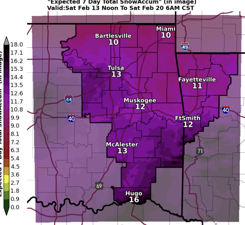
MO/KS/AR/OK 2020-2021 "Winter" Discussion
Weatherdemon replied to JoMo's topic in Central/Western States
That’s 15-16/1 for Tulsa which is in the lower range of expectations. -
MO/KS/AR/OK 2020-2021 "Winter" Discussion
Weatherdemon replied to JoMo's topic in Central/Western States
NS... Hmmmm