Weatherdemon
-
Posts
401 -
Joined
-
Last visited
Content Type
Profiles
Blogs
Forums
American Weather
Media Demo
Store
Gallery
Everything posted by Weatherdemon
-
MO/KS/AR/OK 2020-2021 "Winter" Discussion
Weatherdemon replied to JoMo's topic in Central/Western States
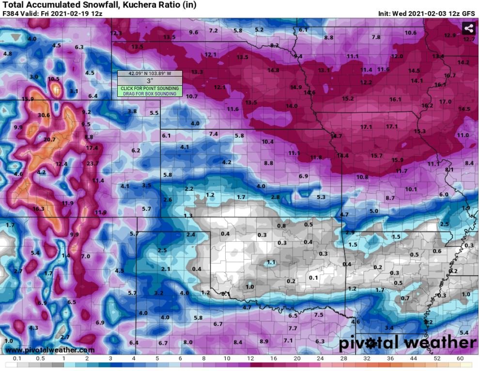
18z NAM being generous for NE OK Sat-Sun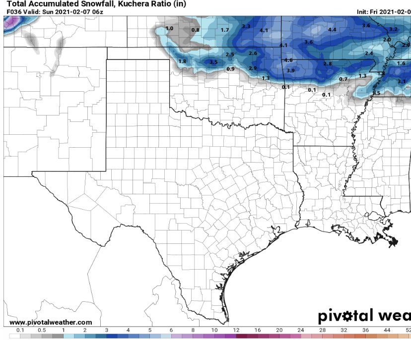
-
MO/KS/AR/OK 2020-2021 "Winter" Discussion
Weatherdemon replied to JoMo's topic in Central/Western States
It was longer than 5 years ago but, I remember a similar situation. Going 20 on 75 N of downtown in my Durango locked in 4WD. I knew it was stupid slick but I tapped my pedal and all 4 tires spun. My 25 minute drive home took over 2 hours. Cars were off the road everywhere. A school bus got stuck outside my house at like 7:30 that night. I threw down sand and cat litter to help when the school folks could there and my wife was shuttling elementary kids in and out of our bathroom since they had been on the bus for almost 4 hours. .1-.2 of freezing drizzle in the 20’s is a nightmare for drivers. -
MO/KS/AR/OK 2020-2021 "Winter" Discussion
Weatherdemon replied to JoMo's topic in Central/Western States
UGH Snow hole in OK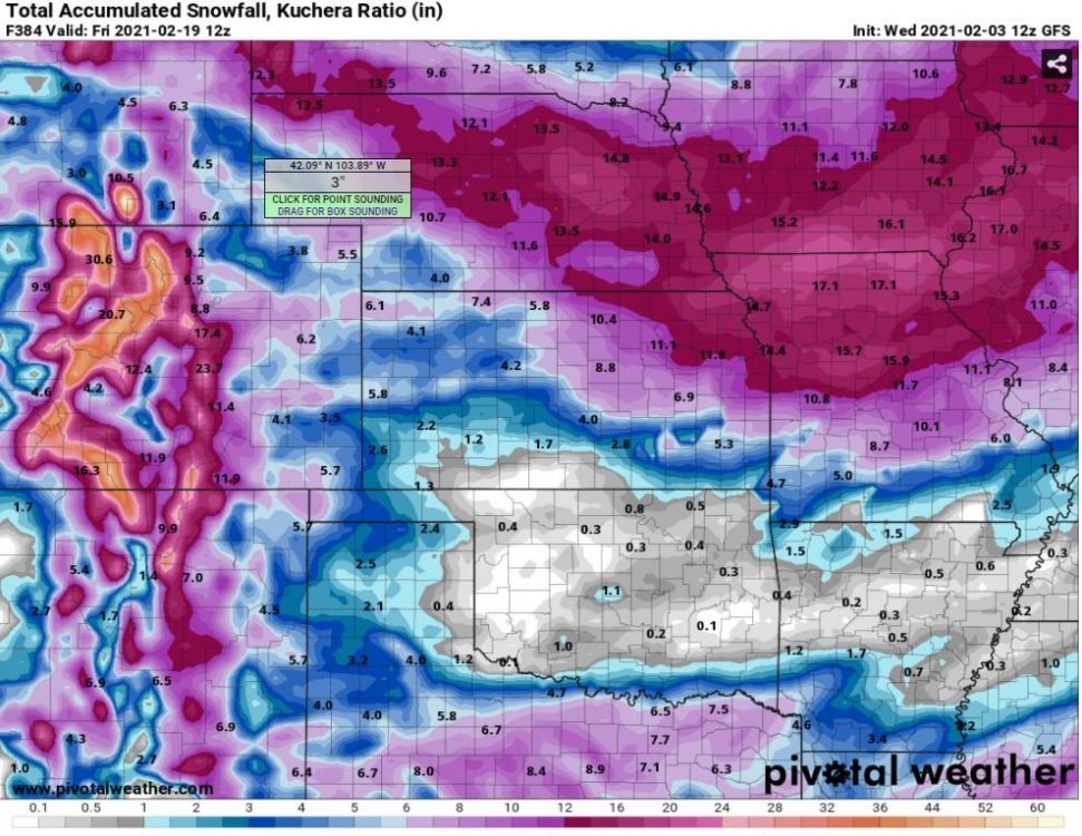
-
MO/KS/AR/OK 2020-2021 "Winter" Discussion
Weatherdemon replied to JoMo's topic in Central/Western States
My hopes for decent precip in NE OK to take advantage of the cold are not high -
MO/KS/AR/OK 2020-2021 "Winter" Discussion
Weatherdemon replied to JoMo's topic in Central/Western States
100 PM CST Tue Jan 5 2021 ...WINTER STORM WATCH IN EFFECT FROM WEDNESDAY EVENING THROUGH THURSDAY MORNING... * WHAT...Heavy snow possible. Total snow accumulations of 3 to 5 inches in the higher elevations generally at or above 2000 feet. Below that, 1 to 3 inches are possible. * WHERE...Carroll and Madison Counties. * WHEN...From Wednesday evening through Thursday morning. * IMPACTS...Plan on slippery road conditions. The hazardous conditions could impact the morning or evening commute. -
MO/KS/AR/OK 2020-2021 "Winter" Discussion
Weatherdemon replied to JoMo's topic in Central/Western States
Not liking the model trends for the weekend snow in OK -
MO/KS/AR/OK 2020-2021 "Winter" Discussion
Weatherdemon replied to JoMo's topic in Central/Western States
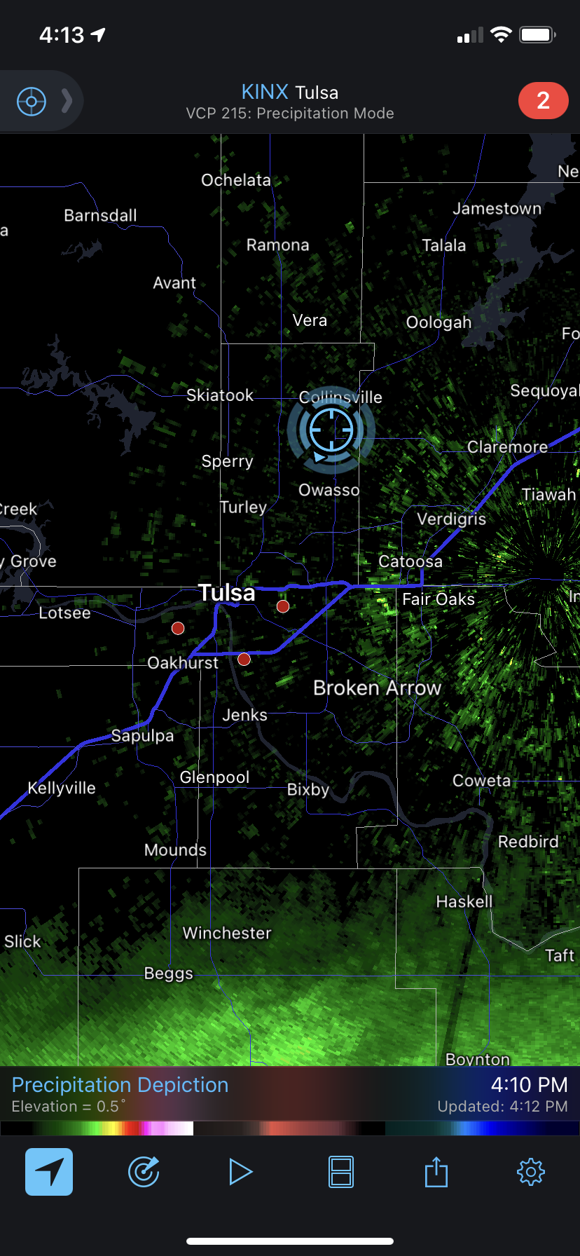
Seeing some flurries just S of Collinsville. -
MO/KS/AR/OK 2020-2021 "Winter" Discussion
Weatherdemon replied to JoMo's topic in Central/Western States
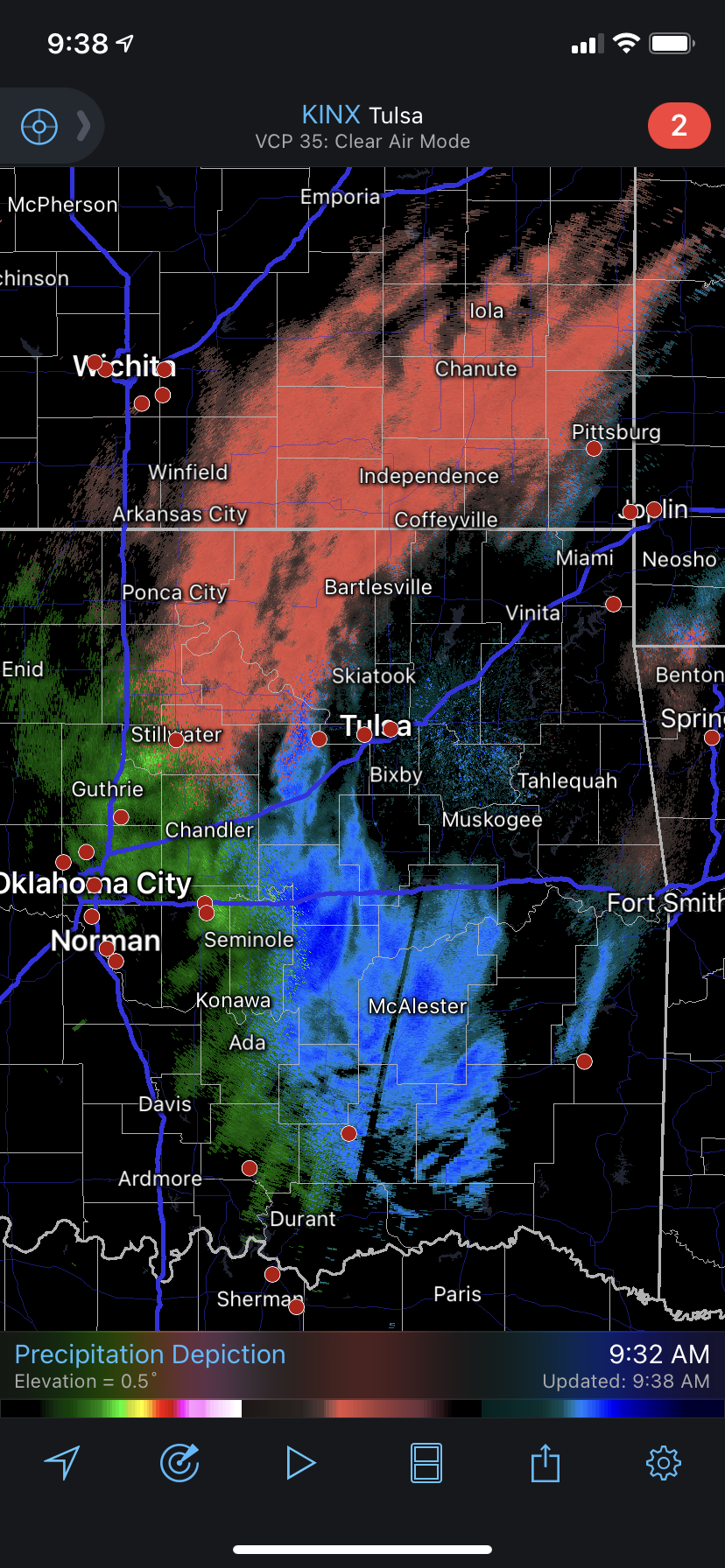
Radar more active than I expected this morning.
-
MO/KS/AR/OK 2020-2021 "Winter" Discussion
Weatherdemon replied to JoMo's topic in Central/Western States
3rd time it’s snowed here this season. Only accumulated twice but, it’s been nice! Ended up with 2 inches SW of Collinsville. -
MO/KS/AR/OK 2020-2021 "Winter" Discussion
Weatherdemon replied to JoMo's topic in Central/Western States
Just S of Collinsville -
MO/KS/AR/OK 2020-2021 "Winter" Discussion
Weatherdemon replied to JoMo's topic in Central/Western States
Tiny amounts of sleet mixing in with the rain here. -
MO/KS/AR/OK 2020-2021 "Winter" Discussion
Weatherdemon replied to JoMo's topic in Central/Western States
It’s gotta be 32.1 here. my thermometer shows 34 and it’s consistently 2 degrees too warm being on my back porch. Just a cold rain here. -
MO/KS/AR/OK 2020-2021 "Winter" Discussion
Weatherdemon replied to JoMo's topic in Central/Western States
I feel you! I’m a nut hair over 32 here and just rain -
MO/KS/AR/OK 2020-2021 "Winter" Discussion
Weatherdemon replied to JoMo's topic in Central/Western States
We’re at 122nd St N and Garnett back in Country Estates. -
MO/KS/AR/OK 2020-2021 "Winter" Discussion
Weatherdemon replied to JoMo's topic in Central/Western States
Your radar view doesn’t match up with mine.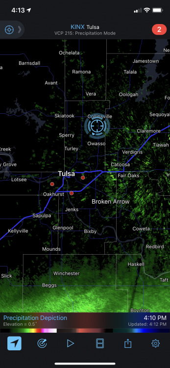
-
MO/KS/AR/OK 2020-2021 "Winter" Discussion
Weatherdemon replied to JoMo's topic in Central/Western States
Norman not real confident... “Still uncertainty about the winter weather (where/what type & how much) over the next couple of days. The forecast will likely change so check for the latest updates.” -
MO/KS/AR/OK 2020-2021 "Winter" Discussion
Weatherdemon replied to JoMo's topic in Central/Western States
For Tulsa as well! -
MO/KS/AR/OK 2020-2021 "Winter" Discussion
Weatherdemon replied to JoMo's topic in Central/Western States
Just saw an NWS report of 2.5 inches around 131st St S and Harvard. -
MO/KS/AR/OK 2020-2021 "Winter" Discussion
Weatherdemon replied to JoMo's topic in Central/Western States
LOL, you live extremely close to me. I'm at work but, my cameras show nada at home -
MO/KS/AR/OK 2020-2021 "Winter" Discussion
Weatherdemon replied to JoMo's topic in Central/Western States
My sis just sent a video from 98th and Memorial. Snow covering the neighborhood roads there. -
MO/KS/AR/OK 2020-2021 "Winter" Discussion
Weatherdemon replied to JoMo's topic in Central/Western States
URGENT - WINTER WEATHER MESSAGE National Weather Service Tulsa OK 1019 AM CST Wed Dec 30 2020 OKZ057-058-060>067-310000- /O.NEW.KTSA.WW.Y.0010.201230T1619Z-201231T0000Z/ Craig-Ottawa-Tulsa-Rogers-Mayes-Delaware-Creek-Okfuskee-Okmulgee- Wagoner- Including the cities of Vinita, Miami, Tulsa, Claremore, Pryor, Grove, Jay, Sapulpa, Okemah, Okmulgee, and Wagoner 1019 AM CST Wed Dec 30 2020 ...WINTER WEATHER ADVISORY IN EFFECT UNTIL 6 PM CST THIS EVENING... * WHAT...Snow. Additional snow accumulations of up to one inch. * WHERE...Portions of east central and northeast Oklahoma. * WHEN...Until 6 PM CST this evening. * IMPACTS...Plan on slippery road conditions in heavier snow bands. PRECAUTIONARY/PREPAREDNESS ACTIONS... -
MO/KS/AR/OK 2020-2021 "Winter" Discussion
Weatherdemon replied to JoMo's topic in Central/Western States
Coming down nice at 51st and Sheridan in Tulsa. Pretty fat flakes! -
Central/Western Medium-Long Range Discussion
Weatherdemon replied to andyhb's topic in Central/Western States
Felt a twinge if hope reviewing models today -
Central/Western Medium-Long Range Discussion
Weatherdemon replied to andyhb's topic in Central/Western States
Man, I hope so! -
Central/Western Medium-Long Range Discussion
Weatherdemon replied to andyhb's topic in Central/Western States
Ugh... just took a look at the models and this simply sucks.