Weatherdemon
-
Posts
401 -
Joined
-
Last visited
About Weatherdemon

- Birthday 06/08/1972
Recent Profile Visitors


-
Severe Weather May 26th- 28th 2021
Weatherdemon replied to weatherextreme's topic in Central/Western States
Public | Counties | Probabilities | Aviation | Warnings | Initial RADAR Hazard Tornadoes EF2+ Tornadoes Likelihood Moderate Low Severe Wind 65 kt+ Wind High Moderate Severe Hail 2"+ Hail High Moderate Note: The expiration time in the watch graphic is amended if the watch is replaced, cancelled or extended. Note: Click for Watch Status Reports. SEL5 URGENT - IMMEDIATE BROADCAST REQUESTED Tornado Watch Number 215 NWS Storm Prediction Center Norman OK 1155 AM CDT Thu May 27 2021 The NWS Storm Prediction Center has issued a * Tornado Watch for portions of Northern and Central Oklahoma * Effective this Thursday morning and evening from 1155 AM until 700 PM CDT. * Primary threats include... A couple tornadoes possible Scattered damaging winds and isolated significant gusts to 80 mph likely Scattered large hail and isolated very large hail events to 3 inches in diameter likely SUMMARY...Thunderstorms will develop and intensify through the afternoon across the watch area, with supercells possible. Very large hail and damaging winds are the main threat, but there is some concern for a few tornadoes in the most intense cells. The tornado watch area is approximately along and 65 statute miles north and south of a line from 50 miles west northwest of Clinton OK to 20 miles south southeast of Fayetteville AR. For a complete depiction of the watch see the associated watch outline update (WOUS64 KWNS WOU5). PRECAUTIONARY/PREPAREDNESS ACTIONS... REMEMBER...A Tornado Watch means conditions are favorable for tornadoes and severe thunderstorms in and close to the watch area. Persons in these areas should be on the lookout for threatening weather conditions and listen for later statements and possible warnings. -
Severe Weather May 26th- 28th 2021
Weatherdemon replied to weatherextreme's topic in Central/Western States
Mesoscale Discussion 0764 NWS Storm Prediction Center Norman OK 1129 AM CDT Thu May 27 2021 Areas affected...eastern Texas Panhandle...Oklahoma. far southern Kansas and northwest Arkansas Concerning...Severe potential...Watch likely Valid 271629Z - 271730Z Probability of Watch Issuance...80 percent SUMMARY...Thunderstorms are expected to develop across western through central Oklahoma by early afternoon and gradually spread east. Supercells with isolated large hail will be the initial main threat, but isolated damaging wind and a few tornadoes are also possible. DISCUSSION...Latest objective analysis show the atmosphere to be moderately to strongly unstable (2500-3000 J/kg MLCAPE) across western through central OK supported by steep mid-level lapse rates above rich low-level moisture with surface dewpoints in the low 70s F. Latest trends in radar show a few showers developing within a modest warm advection regime in the pre-frontal warm sector across western OK. While some remnant capping may still exist, convective inhibition should gradually weaken as temperatures rise into the low 80s F. Rap analysis data show a mid-level jet approaching this region from the west, and effective bulk shear profiles will gradually increase to between 40 and 50 kt through the afternoon. This environment should support discrete supercells as the initial storm mode with large to very large hail likely. While low-level hodographs are not particularly large with 0-1 km storm relative helicity between 100-150 m2/s2 isolated tornadoes cannot be ruled out given degree of instability and a very moist boundary layer with relatively low LCLS. Additional storms may develop along the cold front by late afternoon across southern KS into northern OK and these will also likely become severe. ..Dial/Hart.. 05/27/2021 -
Severe Weather May 26th- 28th 2021
Weatherdemon replied to weatherextreme's topic in Central/Western States
Area Forecast Discussion National Weather Service Tulsa OK 1124 AM CDT Thu May 27 2021 .DISCUSSION... Forecast has been updated this morning based on the latest trends in the data. Model soundings this morning were weakening the cap fairly quickly today, likely due to ascent from warm advection/isentropic lift evident on 305K surface. 12Z OUN sounding showed very steep mid level lapse rates and large CAPE, with decent deep layer shear. Low level shear is still fairly weak. Storms are already ongoing across NE OK, evidence of weakening cap. More storms to develop later today as daytime heating continues, even with quite a bit of cloud cover, as very rich low level moisture is in place with low 70s dewpoints. Very large hail and damaging winds main threats. Tornado potential should be localized and focused along outflow boundaries, though given the time of year and the environment, the potential does exist for a strong tornado. Storms eventually congeal into an MCS and plow southeast with wider swaths of damaging wind potential becoming main threat. A QLCS tornado threat will exist on any bowing structures that surge to the east to northeast. With multiple rounds of storms possible along and north of I40 thru tonight, a flash flood watch has been issued. -
Severe Weather May 26th- 28th 2021
Weatherdemon replied to weatherextreme's topic in Central/Western States
https://www.spc.noaa.gov/products/md/2021/md0763.html Mesoscale Discussion 0763 NWS Storm Prediction Center Norman OK 1104 AM CDT Thu May 27 2021 Areas affected...portions of southeastern Kansas and northeastern Oklahoma across the Ozarks and into parts of southern Illinois Concerning...Severe potential...Watch likely Valid 271604Z - 271730Z Probability of Watch Issuance...80 percent SUMMARY...A gradual increase in storm coverage/intensity -- and attendant severe risk -- over the next couple of hours will likely require WW issuance DISCUSSION...Latest visible satellite imagery shows widespread/ongoing convection and attendant cloud cover, and several outflow boundaries, from southeastern Kansas and Oklahoma east to the mid Mississippi Valley. The ongoing convection is occurring south and east of a cold front extending from a low in southwestern Iowa, southwestward across Kansas to the Texas Panhandle. Ahead of a loosely continuous, composite outflow boundary arcing from northwest of St. Louis westward to southwestern Missouri, and then into northeastern Oklahoma, some heating/destabilization is underway -- particularly from southern Illinois westward across the Ozarks. This trend should continue, resulting in a gradual increase in convective coverage and intensity over the next couple of hours. Area VWP data indicates around 30 kt low-level south-southwesterly flow across the warm sector, veering to west-southwesterly at mid levels. This is providing sufficient shear for organized/mixed-mode convection, and therefore expect severe potential -- mainly in the form of damaging winds and hail -- to gradually increase in concert with convective intensification. As such, expect WW issuance to be required within the next hour. -
MO/KS/AR/OK 2020-2021 "Winter" Discussion
Weatherdemon replied to JoMo's topic in Central/Western States
Partly cloudy with flurries. These systems have held in until the end around here every time the last couple of weeks! -
MO/KS/AR/OK 2020-2021 "Winter" Discussion
Weatherdemon replied to JoMo's topic in Central/Western States
LOL! I just posted about the same -
MO/KS/AR/OK 2020-2021 "Winter" Discussion
Weatherdemon replied to JoMo's topic in Central/Western States
Still having moderate snow in Owasso with medium size flakes. This round has been putting down a layer on the trees so it’s really pretty! I’m guessing this round has brought around 4 inches. -
MO/KS/AR/OK 2020-2021 "Winter" Discussion
Weatherdemon replied to JoMo's topic in Central/Western States
OG&E just had a 20K outage in OK. Arkansas may start rolling blackouts... -
MO/KS/AR/OK 2020-2021 "Winter" Discussion
Weatherdemon replied to JoMo's topic in Central/Western States
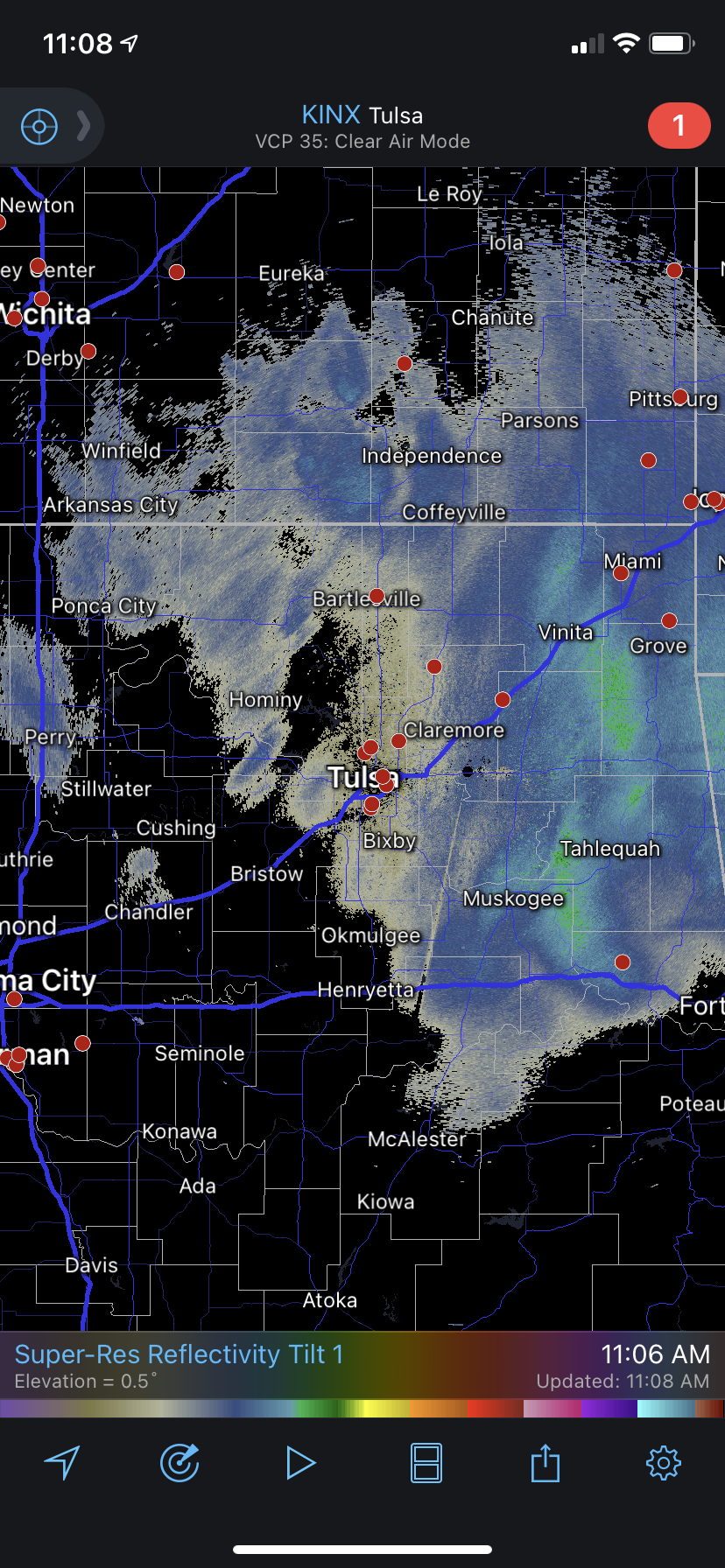
Guess we have a few flakes to go...More redevelopment W of Tulsa.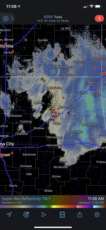
-
MO/KS/AR/OK 2020-2021 "Winter" Discussion
Weatherdemon replied to JoMo's topic in Central/Western States
Another 4-6 would be nice! -
MO/KS/AR/OK 2020-2021 "Winter" Discussion
Weatherdemon replied to JoMo's topic in Central/Western States
Seriously! if clouds don’t move in, we might hit -15. -
MO/KS/AR/OK 2020-2021 "Winter" Discussion
Weatherdemon replied to JoMo's topic in Central/Western States
Snow ending here with the sun trying to peek out. -
MO/KS/AR/OK 2020-2021 "Winter" Discussion
Weatherdemon replied to JoMo's topic in Central/Western States
Getting some decent size flakes and moderate snowfall right now! -
MO/KS/AR/OK 2020-2021 "Winter" Discussion
Weatherdemon replied to JoMo's topic in Central/Western States
I was quite surprised as well! -
MO/KS/AR/OK 2020-2021 "Winter" Discussion
Weatherdemon replied to JoMo's topic in Central/Western States
Yikes! that sucks!