

Weatherdemon
-
Posts
401 -
Joined
-
Last visited
Content Type
Profiles
Blogs
Forums
American Weather
Media Demo
Store
Gallery
Everything posted by Weatherdemon
-
MO/KS/AR/OK 2019-2020 Winter Wonderland Discussion
Weatherdemon replied to JoMo's topic in Central/Western States
Severe Thunderstorm Warning from OUN... with sleet OUN Tweet -
MO/KS/AR/OK 2019-2020 Winter Wonderland Discussion
Weatherdemon replied to JoMo's topic in Central/Western States
Tulsa NWS posted this earlier -
MO/KS/AR/OK 2019-2020 Winter Wonderland Discussion
Weatherdemon replied to JoMo's topic in Central/Western States
Temps running about +1 compared to the 17z HRRR. HRRR doesn't typically overdue freezing rain from what I remember. -
MO/KS/AR/OK 2019-2020 Winter Wonderland Discussion
Weatherdemon replied to JoMo's topic in Central/Western States
Not confident in precip amounts or temp. I would lean toward colder than shown for sure. -
MO/KS/AR/OK 2019-2020 Winter Wonderland Discussion
Weatherdemon replied to JoMo's topic in Central/Western States
Got a glaze up here but it looks like the precip is shifting east faster than models indicated -
MO/KS/AR/OK 2019-2020 Winter Wonderland Discussion
Weatherdemon replied to JoMo's topic in Central/Western States
Wouldn't surprise me to see some freezing drizzle sticking around after the main rain shield moves east tonight. -
MO/KS/AR/OK 2019-2020 Winter Wonderland Discussion
Weatherdemon replied to JoMo's topic in Central/Western States
Seriously? Wow -
MO/KS/AR/OK 2019-2020 Winter Wonderland Discussion
Weatherdemon replied to JoMo's topic in Central/Western States
Pics on Twitter in Stillawater water showing what looks like near 1/2 inch of ice on trees -
MO/KS/AR/OK 2019-2020 Winter Wonderland Discussion
Weatherdemon replied to JoMo's topic in Central/Western States
Tulsa NWS with a new Winter Weather Advisory basically along and NW of I44. 31.4 degree drop just S of Collinsville since 7:35. Temp now at 38.2 -
MO/KS/AR/OK 2019-2020 Winter Wonderland Discussion
Weatherdemon replied to JoMo's topic in Central/Western States
And now from 69.6 to 49 in 18 minutes -
MO/KS/AR/OK 2019-2020 Winter Wonderland Discussion
Weatherdemon replied to JoMo's topic in Central/Western States
Wild ride at my house last night.... -
MO/KS/AR/OK 2019-2020 Winter Wonderland Discussion
Weatherdemon replied to JoMo's topic in Central/Western States
Neither am I. Tulsa NWS sticking with hundredths of an inch but no amount of freezing rain is good. -
MO/KS/AR/OK 2019-2020 Winter Wonderland Discussion
Weatherdemon replied to JoMo's topic in Central/Western States
NAM hammering parts of E OK Tues night into Wed with accumulating freezing rain to 1.39 inches. -
MO/KS/AR/OK 2019-2020 Winter Wonderland Discussion
Weatherdemon replied to JoMo's topic in Central/Western States
&^%$# Models hung on until Sun AM and now doing their thing and killing it... which has been accurate this close but still frustrating. -
MO/KS/AR/OK 2019-2020 Winter Wonderland Discussion
Weatherdemon replied to JoMo's topic in Central/Western States
Late next week has gotten the attention of local Mets and Tulsa NWS. Looks like there is potential for as much as a 1/2 inch of ice. Not devastating but would be significant pain. -
MO/KS/AR/OK 2019-2020 Winter Wonderland Discussion
Weatherdemon replied to JoMo's topic in Central/Western States
Left downtown around 3:15 and the IDL was really slick. HWY 75 N had slick bridges and a couple wrecks. One closed 75 SB. 51 west was closed for a bit too. Sidewalks were slick when I got home as well. Things are looking better for roads at last for the N half of Tulsa as dry air works in. -
MO/KS/AR/OK 2019-2020 Winter Wonderland Discussion
Weatherdemon replied to JoMo's topic in Central/Western States
Canadian, GFS, and Euro all on an early week system next week putting down 1-4 in most of OK. -
MO/KS/AR/OK 2019-2020 Winter Wonderland Discussion
Weatherdemon replied to JoMo's topic in Central/Western States
Had a good 1.5 in Owasso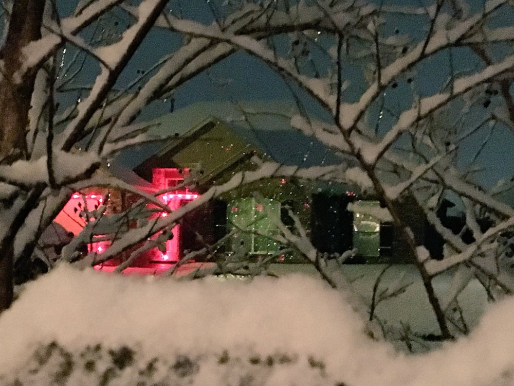
-
MO/KS/AR/OK 2019-2020 Winter Wonderland Discussion
Weatherdemon replied to JoMo's topic in Central/Western States
Owasso has had moderate sleet off and on with rain tonight. Had heavy enough sleet to accumulate on sidewalk and cars. it transitioned to freezing rain and glazed everything and has been off and on snow or sleet since. Had a 15 minute period of moderate snow with big flakes around 10 that started to accumulate before it ended. Back to sleet right now with some light accumulations on cars and roofs. -
MO/KS/AR/OK 2019-2020 Winter Wonderland Discussion
Weatherdemon replied to JoMo's topic in Central/Western States
Yea, must have had an issue that popped up that one graphic. -
MO/KS/AR/OK 2019-2020 Winter Wonderland Discussion
Weatherdemon replied to JoMo's topic in Central/Western States
Tulsa NWS with a big bump in totals.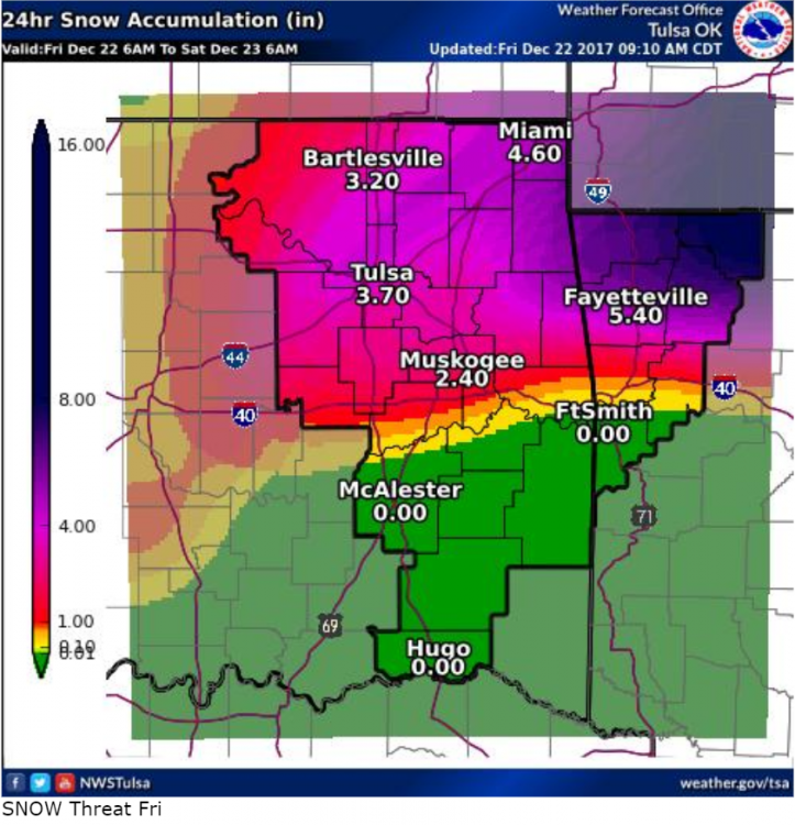
-
MO/KS/AR/OK 2019-2020 Winter Wonderland Discussion
Weatherdemon replied to JoMo's topic in Central/Western States
18z NAM saying the same thing. -
MO/KS/AR/OK 2019-2020 Winter Wonderland Discussion
Weatherdemon replied to JoMo's topic in Central/Western States
GFS seems to really like keeping a big storm on the horizon about a week out but killing each one 3-4 days out. -
MO/KS/AR/OK 2019-2020 Winter Wonderland Discussion
Weatherdemon replied to JoMo's topic in Central/Western States
12z NAM3K puts down up to 5 inches of ice in SC/SW OK and almost 8 in TX Fri/Sat. NAM more realistic at a little over an inch max mainly in SW OK. -
MO/KS/AR/OK 2019-2020 Winter Wonderland Discussion
Weatherdemon replied to JoMo's topic in Central/Western States
GFS went the way of the the Euro and killed the SW L.


