Weatherdemon
-
Posts
401 -
Joined
-
Last visited
Content Type
Profiles
Blogs
Forums
American Weather
Media Demo
Store
Gallery
Everything posted by Weatherdemon
-
MO/KS/AR/OK 2019-2020 Winter Wonderland Discussion
Weatherdemon replied to JoMo's topic in Central/Western States
12z GEM a little more tame than 00z.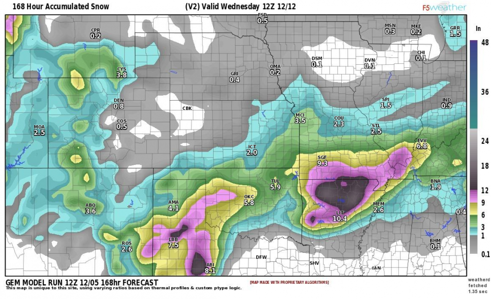
-
MO/KS/AR/OK 2019-2020 Winter Wonderland Discussion
Weatherdemon replied to JoMo's topic in Central/Western States
GFS is warmer with about 40% less QPF N of I40. -
MO/KS/AR/OK 2019-2020 Winter Wonderland Discussion
Weatherdemon replied to JoMo's topic in Central/Western States
NAM is a little different than the 12K.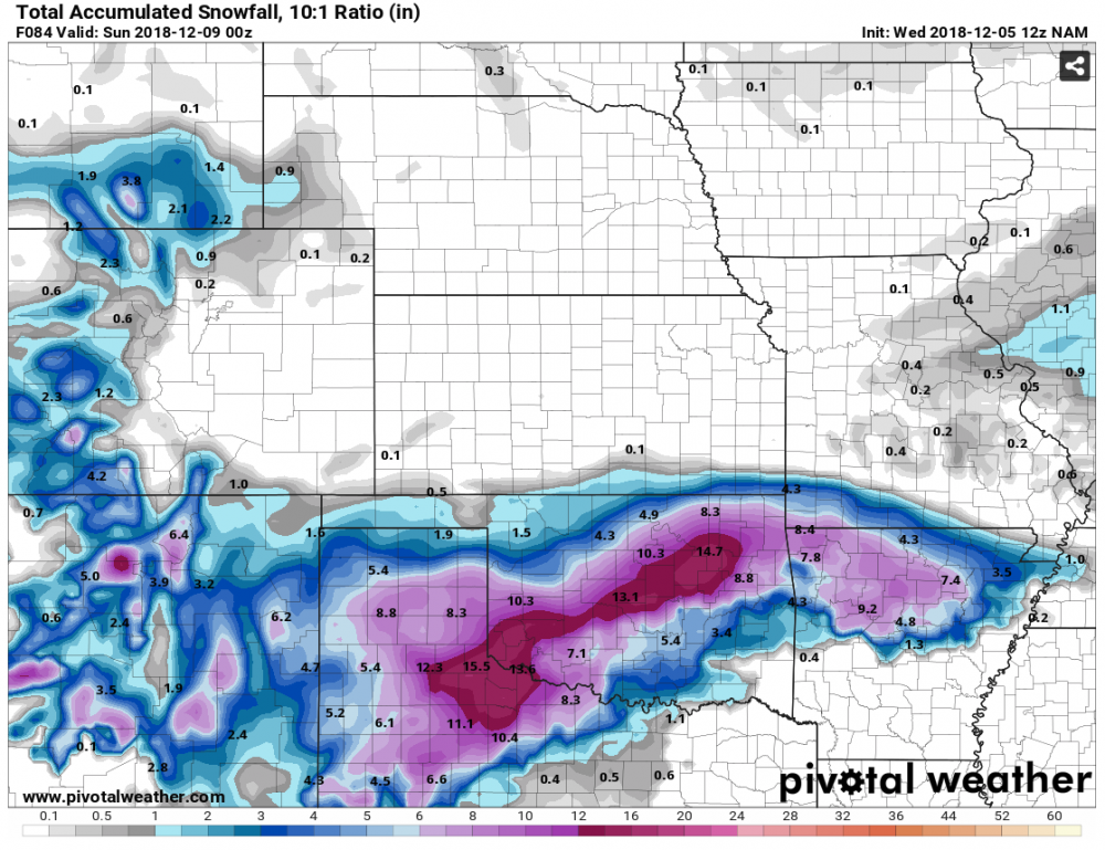
-
MO/KS/AR/OK 2019-2020 Winter Wonderland Discussion
Weatherdemon replied to JoMo's topic in Central/Western States
Yea, it's seemed out to lunch compared to most but there are some in agreement. BTW... here are the OUN graphics. -
MO/KS/AR/OK 2019-2020 Winter Wonderland Discussion
Weatherdemon replied to JoMo's topic in Central/Western States
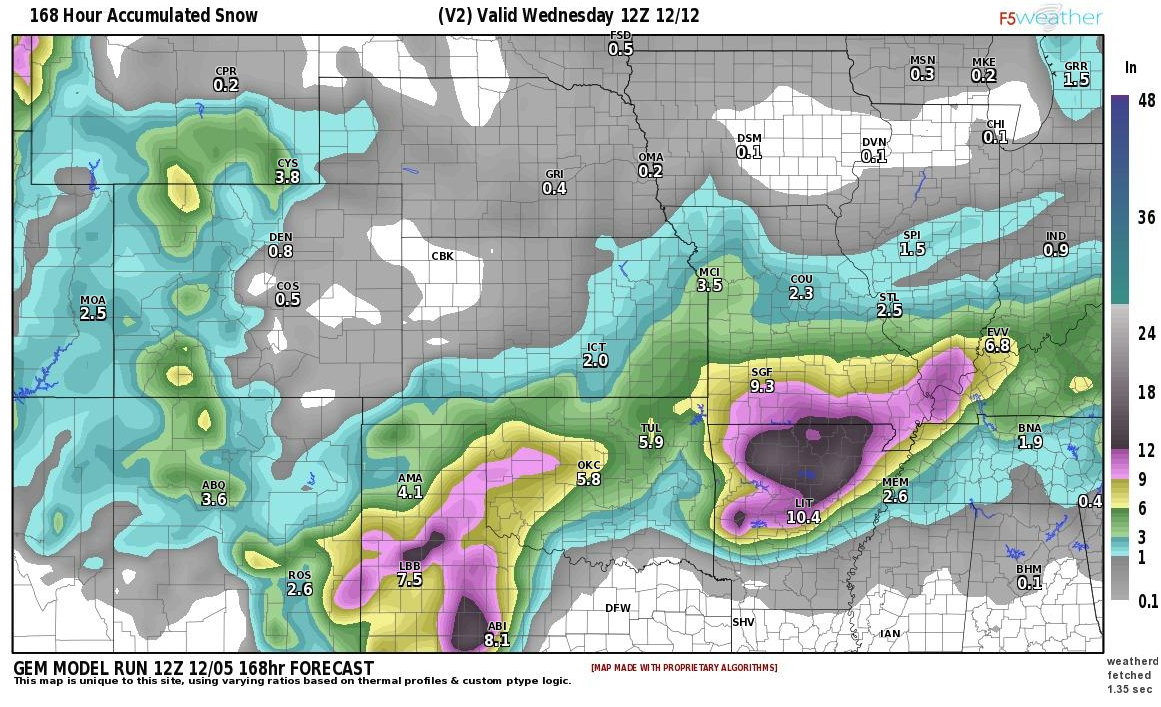
Just for giggle's I took the GDPS (6.8), UKMET-G (5.0), GEM (8.2), NAM (14.7), NAM12K (12.5), and Euro (4) to see the average forecast amount for Tulsa. 8.47 was the number. -
MO/KS/AR/OK 2019-2020 Winter Wonderland Discussion
Weatherdemon replied to JoMo's topic in Central/Western States
Thanks! Those seem more reasonable. I looked back at the last 3 NAM runs and the trend is interesting on snow amounts. 00z: 1.5 at 6am Sat 06z: 2.3 at 6am Sat 12z: 5.0 at 6am Sat. -
MO/KS/AR/OK 2019-2020 Winter Wonderland Discussion
Weatherdemon replied to JoMo's topic in Central/Western States
12Z NAM, these totals are with the storm still not out of the area just yet. We all know the NAM totals are going to be exaggerated this far out, but it corroborates with the Euro pretty well. I wonder when the GFS is going to get on board(if ever). What are the Euro amounts? NAM is just ballistic with snow N of I40 and tons of ice with some snow S. And, like you said, with precip on-going. -
MO/KS/AR/OK 2019-2020 Winter Wonderland Discussion
Weatherdemon replied to JoMo's topic in Central/Western States
OUN official is generally 2-4 inches of snow except WC OK where 4-6 is shown and ice amounts up to a .5 inch generally along and S of I44 and I40 in C and W OK with lighter amounts to the KS border. Tulsa NWS in line with them with 1-3 inches of snow and under .1 of ice for NE OK. -
MO/KS/AR/OK 2019-2020 Winter Wonderland Discussion
Weatherdemon replied to JoMo's topic in Central/Western States
06z NAM and 12K both indicating heavy snow for much of OK. 12K generally 3-11 with a sharp cutoff along the OK/KS border... through noon Sat. NAM generally in line but with high amounts of 7-8 but hits SC and SW OK with .5 to 1inch + amounts of ice. 12K precip type indicates roughly the same. -
MO/KS/AR/OK 2019-2020 Winter Wonderland Discussion
Weatherdemon replied to JoMo's topic in Central/Western States
OKZ004>031-033>040-044-TXZ083>088-052200- /O.NEW.KOUN.WS.A.0001.181207T1200Z-181209T0600Z/ Harper-Woods-Alfalfa-Grant-Kay-Ellis-Woodward-Major-Garfield- Noble-Roger Mills-Dewey-Custer-Blaine-Kingfisher-Logan-Payne- Beckham-Washita-Caddo-Canadian-Oklahoma-Lincoln-Grady-McClain- Cleveland-Pottawatomie-Seminole-Harmon-Greer-Kiowa-Jackson- Tillman-Comanche-Stephens-Garvin-Cotton-Hardeman-Foard-Wilbarger- Wichita-Knox-Baylor- Including the cities of Buffalo, Laverne, Alva, Cherokee, Helena, Carmen, Medford, Pond Creek, Lamont, Wakita, Ponca City, Blackwell, Shattuck, Arnett, Gage, Fargo, Woodward, Fairview, Enid, Perry, Cheyenne, Hammon, Seiling, Vici, Taloga, Leedey, Weatherford, Clinton, Watonga, Geary, Okeene, Kingfisher, Hennessey, Okarche, Guthrie, Stillwater, Elk City, Sayre, Cordell, Burns Flat, Sentinel, Anadarko, Hinton, Yukon, Concho, El Reno, Mustang, Oklahoma City, Chandler, Stroud, Prague, Meeker, Davenport, Wellston, Chickasha, Tuttle, Purcell, Newcastle, Blanchard, Norman, Moore, Shawnee, Seminole, Wewoka, Hollis, Mangum, Granite, Hobart, Snyder, Altus, Frederick, Lawton, Duncan, Pauls Valley, Lindsay, Wynnewood, Walters, Temple, Quanah, Crowell, Vernon, Sheppard AFB, Wichita Falls, Munday, Knox City, and Seymour 336 AM CST Wed Dec 5 2018 ...WINTER STORM WATCH IN EFFECT FROM FRIDAY MORNING THROUGH SATURDAY EVENING... * WHAT...Heavy mixed precipitation possible. Total snow accumulations of 2 to 4 inches and ice accumulations of around three tenths of an inch are possible. * WHERE...The heavier snow accumulations will mainly be across northern Oklahoma, especially near the Kansas border. The heavier ice accumulations are expected to extend from southwest Oklahoma into central Oklahoma, including Oklahoma City. * WHEN...From Friday morning through Saturday evening. * ADDITIONAL DETAILS...Power outages and tree damage are likely due to the ice. Road conditions will vary across Oklahoma and western north Texas, depending on ground temperatures and the rate of accumulation of snow and ice. Ice may accumulate on bridges and overpasses, even where main roads do not freeze.The hazardous conditions could impact the morning and evening commutes. PRECAUTIONARY/PREPAREDNESS ACTIONS... A Winter Storm Watch means there is potential for significant snow, sleet or ice accumulations that may impact travel. Continue to monitor the latest forecasts. -
MO/KS/AR/OK 2019-2020 Winter Wonderland Discussion
Weatherdemon replied to JoMo's topic in Central/Western States
OUN Discussion: DISCUSSION... No significant changes to the previous forecast. The focus continues to be primarily on winter weather that is expected late this week into Saturday. Will be a little more brief on meteorological details given time constraints today, but will try and explain our latest thinking for this complicated forecast below. Latest visible satellite shows persistent low stratus across much of the area. Mid level saturation atop the stratus layer resulted in either deep enough saturation or a seeder feeder scenario to where some reports of snow flurries were received today. Precipitation was all non-measurable today though. A weak shortwave within west- northwesterly flow helped force the mid- level saturation and is now shifting east. Low level southerly flow/veered 850-mb flow should result in warmer temperatures tomorrow and less cloud cover as stratus erodes. On Thursday, a cold front sent south by northern stream shortwave will reach the area bringing colder temperatures. Sub-freezing temperatures should cover the northeast two thirds of the area by Friday morning. We adjusted hourly temperatures to show little or no increase during the day. Northeast winds and cold advection in a shallow layer along with clouds and precipitation generally yields little diurnal swing in temperatures. Given this, we have emphasized freezing rain potential roughly along and just south of the I-40 corridor. Further north, a less pronounced warm nose and overall deeper colder air mass should support some sleet and snow. As we've been saying the last couple days, confidence in position/timing of synoptic features and resulting forcing for ascent/precip/QPF is fairly high for the time range, but the main uncertainties are with magnitude of cold air. Models may not be parameterizing boundary layer conditions optimally to guide our precipitation type forecast (i.e., rain vs freezing rain). Furthermore, they've already struggled with boundary layer conditions in the short term (i.e., moisture and stratus issues the last two days). Upstream air mass behind aforementioned cold front may not modify significantly given snow cover down to I-70, and any errors in low-level dew points will have implications for wet bulb temperatures as well. So, the precipitation type forecast remains uncertain. Even with the higher confidence in synoptic features, a slight deviation of the track to the south and/or slight slowing and deepening of the closed mid-upper low may delay or lower precipitation chances across the north on Friday. But as of now, this seems like a pretty straight forward isentropic ascent scenario with high probabilities of at least 0.10-0.25 inches of QPF widespread. Icing near or slightly below freezing temperatures wouldn't be efficient enough for a straight 1:1 correlation of icing amounts, but given potential error in QPF amounts and possibility of slightly colder air than currently anticipated, we're emphasizing the freezing rain potential. Details in boundary layer T/Tw will become more clear in subsequent forecasts as the event nears. Applying conceptual models, we're likely to see a fairly substantial TROWAL/deformation snow band into Saturday, with potential for 3-5 (locally higher) snowfall amounts. Right now given the thermal structure in Bufkit soundings and resultant ptype transition, it appears the higher amounts would be over western and northern Oklahoma. But, confidence in accumulating snow is increasing -
MO/KS/AR/OK 2019-2020 Winter Wonderland Discussion
Weatherdemon replied to JoMo's topic in Central/Western States
12z GFS is 8 degrees cooler in Tulsa than the 06z run with 36 vs 44 Friday at 06z 12z GFS still 6 degrees warmer in Tulsa than the 12z NAM at 36 vs 30 at that same time. 12z GEM warmer than the 12z NAM at 33 vs 30 but cooler than the GFS with 33 vs 36. GEM seems to be a good middle ground right now. -
MO/KS/AR/OK 2019-2020 Winter Wonderland Discussion
Weatherdemon replied to JoMo's topic in Central/Western States
12z is 8 degrees cooler in Tulsa than the 06z run with 36 vs 44 Friday at 06z but still 6 degrees warmer in Tulsa than the 12z NAM at 36 vs 30 at that same time. I do like that it is back to trending colder. -
MO/KS/AR/OK 2019-2020 Winter Wonderland Discussion
Weatherdemon replied to JoMo's topic in Central/Western States
I don't believe so. They take into account new OBS but I believe that's it. -
MO/KS/AR/OK 2019-2020 Winter Wonderland Discussion
Weatherdemon replied to JoMo's topic in Central/Western States
Tulsa NWS upping their snow totals and decreasing ice amounts to very, very low.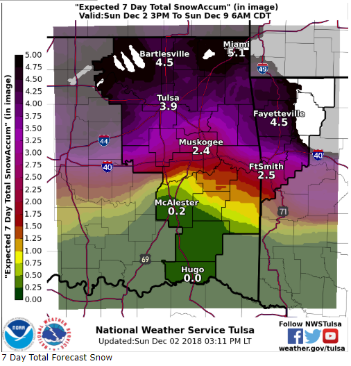
-
MO/KS/AR/OK 2019-2020 Winter Wonderland Discussion
Weatherdemon replied to JoMo's topic in Central/Western States
GFS: v3: On Ice, Euro showing no ice. Canadian hits SC OK pretty hard. GFS hits SW OK, v3 his EC OK.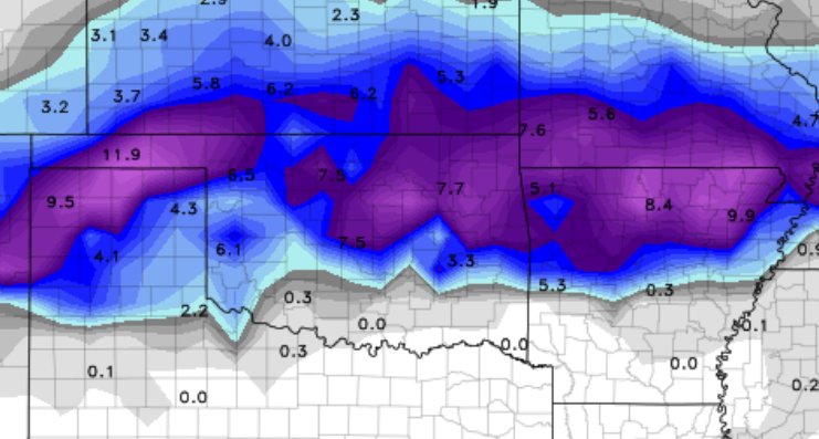
-
MO/KS/AR/OK 2019-2020 Winter Wonderland Discussion
Weatherdemon replied to JoMo's topic in Central/Western States
Canadian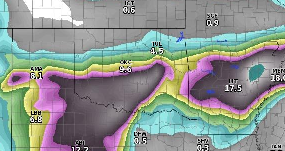
-
MO/KS/AR/OK 2019-2020 Winter Wonderland Discussion
Weatherdemon replied to JoMo's topic in Central/Western States
OUN AFD 170 FXUS64 KOUN 012117 AFDOUN Area Forecast Discussion National Weather Service Norman OK 317 PM CST Sat Dec 1 2018 .DISCUSSION... Gusty WNW winds have persisted across western and northern OK this afternoon but should decrease fairly rapidly after sunset. An area of light precipitation continues to wrap around the upper low across southern KS. This precipitation will come very close to entering northern OK around 00Z but for now will keep forecast dry as the low pivots northeastward tonight. The next chance for precipitation will accompany a elongated vort max late tomorrow night through early Mon morning over portions of western OK. Temps will be cold enough for some accumulating snowfall but with limited mid to upper moisture available do not anticipate any accumulation over an inch right now. This could change so it will be watched closely for possible advisory criteria. Warmer temperatures are expected Wed and Thu under a shortwave ridge. Warm, moist advection Thu thru Thu night should support high chance PoPs for light rainfall across central and southern OK. The main concern this forecast period will be the opportunity for a shallow, artic airmass to dive south during the day Thu and overnight into Fri AM. The ECMWF is fairly persistent with an aggressive solution, dropping temps below freezing both Fri and Sat along and north of I-40. Meanwhile, a southern stream shortwave trough is expected to move into west TX Fri. Precipitation remains possible in the extended periods, but it's still unclear how far south and how fast the cold airmass will get for wintry precipitation. For now, have opted to go with the more aggressive ECMWF which is very similar to the parallel run of the GFSFV3. These solutions both suggest a fairly significant winter storm MAY be possible by the end of the week and into next weekend across portions of OK and KS. This may include all wx types including freezing rain, sleet, and snow. Again, there is still much uncertainty regarding precipitation type and timing but the potential for widespread precip appears likely at this time. -
MO/KS/AR/OK 2019-2020 Winter Wonderland Discussion
Weatherdemon replied to JoMo's topic in Central/Western States
Their chiclet page puts 4-7 down Tulsa to the NW. Very little ice but, that’s how the models trended today with deeper cold air. i agree with the above post, someone is in for an ice storm. -
MO/KS/AR/OK 2019-2020 Winter Wonderland Discussion
Weatherdemon replied to JoMo's topic in Central/Western States
It the new day of social media, they almost have too. They don’t need to be first this far out but, they can’t be last. -
MO/KS/AR/OK 2019-2020 Winter Wonderland Discussion
Weatherdemon replied to JoMo's topic in Central/Western States
Excellent point on snowpack! I haven’t looked at that this morning and I should have! -
MO/KS/AR/OK 2019-2020 Winter Wonderland Discussion
Weatherdemon replied to JoMo's topic in Central/Western States
Good stuff! Thanks! FWIW... Tulsa NWS mentioned it at the end of their morning AFD. Your Tigers may have a long tonight with lightning delays vs the Trojans if tonight's forecast pans out. -
MO/KS/AR/OK 2019-2020 Winter Wonderland Discussion
Weatherdemon replied to JoMo's topic in Central/Western States
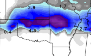
Starting to feel more like an icing event with some light snow on the back end. GFS has tracked further N and keeps most precip liquid. v3 puts down most of the precip as ice in some form generally NW of I44. Euro puts down some decent snow of 3-7 inches along I44. Canadian more in line with the GFS. Less track agreement this morning but still general agreement on the system and it's potential winter impacts so that's good. -
MO/KS/AR/OK 2019-2020 Winter Wonderland Discussion
Weatherdemon replied to JoMo's topic in Central/Western States
I like the general agreement amongst at least 6 models for a winter system for parts of OK during this time. Hope it becomes a matter of how much here and not how close it will be. Would prefer to not have ice though. -
Central/Western Medium-Long Range Discussion
Weatherdemon replied to andyhb's topic in Central/Western States
Ugh... just took a look at the models and this simply sucks.