

jewell2188
-
Posts
550 -
Joined
-
Last visited
Content Type
Profiles
Blogs
Forums
American Weather
Media Demo
Store
Gallery
Everything posted by jewell2188
-
I work for a company that has a vdot contract for snow removal in Fairfax County (merrifield) to be exact, ive been doing it for 9 years now and it amazes me the amount of complaints from citizens whether it’s a large storm or small. If most truly understood the amount of time and hard work that goes into trying to keep roads clear, not one person would say a word. Not to mention the folks who just can’t seem to stay off the roads during snow.....let’s be honest, with the amount of closings yesterday 95% of the traffic had no reason to be out lol. Rant over !!!
-
Deff mixing with sleet in falls church
-
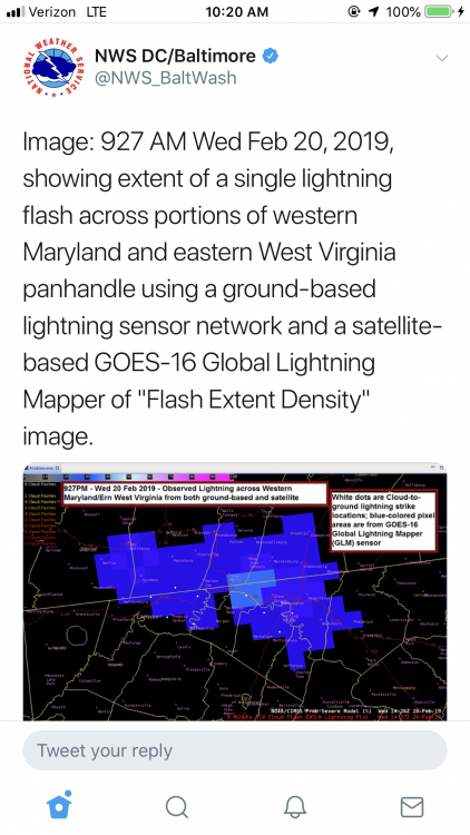
Pretty cool!!
-
Radar confirms this. All sleet in Warrenton va. It’s moving pretty quickly northward.
-
Roads caved so fast, makes you think even harder about the waste of tax payer dollars to pretreat roads.....rant over
-
Ripping in falls church.
-
So to the untrained eye, are we going to be looking at the radar to the south for precip to start filling back in?
-
And what’s that ?
-
The dry air trolling on twitter is real right now....what storm do we never account for the initial dry air battle
-
It just gives them the ability to never be “wrong”
-
Right on que, CWG lowers amounts again....dry air will delay the onset apparently.
-
I like that they are rather confident in the 3-6 95 westward.
-
Pretty sure the nams would be more useful at this range versus euro or gfs
-
Most Mets across the area have lowered or settled with 2-4 inches. Seems reasonable but I do feel the bust potential is quite real.
-
I think most can agree 2-4 inches is a good call area wide. Kinda reminds me of the mid November snow we had....I think totals ranged from 1-3 with some 4 inch amounts before it change to sleet and rain eventually.
-
Back and forth back and forth. When does this nonsense stop? “Disaster”....what were you really expecting from this? Can we let the models play out before making assumptions.
-
I guess NWS will update watches in the morning package?
-
Maybe for your location.
-
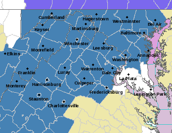
Winter storm watches are up! URGENT - WINTER WEATHER MESSAGE National Weather Service Baltimore MD/Washington DC 338 AM EST Mon Feb 18 2019 DCZ001-MDZ003>006-011-013-014-501>508-VAZ025>031-036>040-050>056- 501>508-WVZ050>053-055-501>506-181645- /O.NEW.KLWX.WS.A.0005.190220T0300Z-190221T0300Z/ District of Columbia-Washington-Frederick MD-Carroll- Northern Baltimore-Southern Baltimore-Prince Georges-Anne Arundel- Extreme Western Allegany-Central and Eastern Allegany- Northwest Montgomery-Central and Southeast Montgomery- Northwest Howard-Central and Southeast Howard-Northwest Harford- Southeast Harford-Augusta-Rockingham-Shenandoah-Frederick VA-Page- Warren-Clarke-Nelson-Albemarle-Greene-Madison-Rappahannock-Orange- Culpeper-Prince William/Manassas/Manassas Park-Fairfax- Arlington/Falls Church/Alexandria-Stafford-Spotsylvania- Northern Fauquier-Southern Fauquier-Western Highland- Eastern Highland-Western Loudoun-Eastern Loudoun- Northern Virginia Blue Ridge-Central Virginia Blue Ridge- Hampshire-Morgan-Berkeley-Jefferson-Hardy-Western Grant- Eastern Grant-Western Mineral-Eastern Mineral-Western Pendleton- Eastern Pendleton- 338 AM EST Mon Feb 18 2019 ...WINTER STORM WATCH IN EFFECT FROM TUESDAY EVENING THROUGH WEDNESDAY EVENING... * WHAT...Heavy snow, mixing with and eventually changing to sleet and then freezing rain. Snow accumulations of 5 or more inches and ice accumulations of a quarter-inch or greater are possible. * WHERE...The District of Columbia, Maryland east of the Appalachians and west of the Chesapeake Bay, central and northern Virginia, and the eastern West Virginia panhandle. * WHEN...From Tuesday evening through Wednesday evening. * ADDITIONAL DETAILS...Travel could be very difficult. The hazardous conditions could impact the morning or evening commute. PRECAUTIONARY/PREPAREDNESS ACTIONS... A Winter Storm Watch means there is potential for significant snow, sleet or ice accumulations that may impact travel. Continue to monitor the latest forecasts. && $$ HTS
-
We are either losing our thump or it was never real to begin with
-
A classic example of wasting tax payer money. And another example of “use the budget or lose it next year”
-
The main moisture plume is pushed to our north and west. SE ridge is flexing...just another way to fail...we always find a way lol
-
It’s a level 1 storm for vdot in nova. Not enough to bring all my plow trucks out of hiding....=disappointment
-
The king just said sit down
-
What are the chances of the “thump” over achieving like we’ve seen many times around here!?


