jewell2188
-
Posts
569 -
Joined
-
Last visited
Content Type
Profiles
Blogs
Forums
American Weather
Media Demo
Store
Gallery
Everything posted by jewell2188
-
2019 Mid-Atlantic Severe Wx - General Discussion
jewell2188 replied to Kmlwx's topic in Mid Atlantic
It seemed 24 hrs ago it could have been a big day today, now the overall setup seems meh -
2019 Mid-Atlantic Severe Wx - General Discussion
jewell2188 replied to Kmlwx's topic in Mid Atlantic
From where? Nothing remotely close -
2019 Mid-Atlantic Severe Wx - General Discussion
jewell2188 replied to Kmlwx's topic in Mid Atlantic
No surprise, cloudy here most of day. -
2019 Mid-Atlantic Severe Wx - General Discussion
jewell2188 replied to Kmlwx's topic in Mid Atlantic
Nudge that south a bit and I’ll take it. -
2019 Mid-Atlantic Severe Wx - General Discussion
jewell2188 replied to Kmlwx's topic in Mid Atlantic
A cold front will approach the area from the north today. The front will stall out nearby on Monday and remain nearly stationary across the area through the middle of next week. It may finally shift southeast of the region by Saturday. && .NEAR TERM /THROUGH TONIGHT/... A very warm and humid air mass will be in place today coupled with a lee-side trof and weak 500 mb wave will aid in t-storm development this afternoon. Mid-level flow will be relatively strong with 40kt at 500mb contributing to 30-40kt of 0-6km bulk shear. A few severe t- storms are expected late this afternoon through late this evening. Northern and central Maryland appears to be at greatest risk of severe thunderstorms with t-storm coverage decreasing markedly south of I-66. Damaging wind gusts appear to be the biggest threat given the moderately strong flow aloft and fast storm motions (~ 30kt). The severe wx threat should wane after 10PM or so, but risk of t- storms will likely persist well into the overnight hours. && .SHORT TERM /MONDAY THROUGH TUESDAY NIGHT/... Monday still appears as it will be the most active day this week with a slow moving front nearby and ripples of upper level energy aiding in t-storm formation. Shear and storm motions will be weaker suggesting an increased flash flood threat especially given mid- level flow becoming parallel to sfc front which will also favor training. CAPE values, on the other hand, are expected to be much higher than on Sunday, which also support a severe wx and flash flood threat. A flash flood watch may be issued for some areas at this time tomorrow once confidence in location of t-storms increases. Simulated satellite imagery from various global models indicate convection will be more widespread and intense than today.- 2,802 replies
-
- 1
-

-
- severe
- thunderstorms
- (and 4 more)
-
2019 Mid-Atlantic Severe Wx - General Discussion
jewell2188 replied to Kmlwx's topic in Mid Atlantic
LWX from this morning Although more precise timing and finer scale details remain uncertain, there is increasing confidence in a heavy rain and flood threat early next week, and possibly again later next week. -
2019 Mid-Atlantic Severe Wx - General Discussion
jewell2188 replied to Kmlwx's topic in Mid Atlantic
It’s been pretty much dying off approaching the I-81 corridor all day.- 2,802 replies
-
- 1
-
-
- severe
- thunderstorms
- (and 4 more)
-
2019 Mid-Atlantic Severe Wx - General Discussion
jewell2188 replied to Kmlwx's topic in Mid Atlantic
Pretty weak sauce garden variety storms. Not even sure a watch was warranted. Drove through the cell approaching warrenton, very typical storm.- 2,802 replies
-
- 1
-
-
- severe
- thunderstorms
- (and 4 more)
-
2019 Mid-Atlantic Severe Wx - General Discussion
jewell2188 replied to Kmlwx's topic in Mid Atlantic
Round two is quickly weakening. -
2019 Mid-Atlantic Severe Wx - General Discussion
jewell2188 replied to Kmlwx's topic in Mid Atlantic
Stepped outside, feels like another meh kind of day. Seems as though we are moving away from the extreme wet pattern we’ve been in for the last year so that’s a plus lol. -
2019 Mid-Atlantic Severe Wx - General Discussion
jewell2188 replied to Kmlwx's topic in Mid Atlantic
Still haven’t had that significant outbreak area wide. -
2019 Mid-Atlantic Severe Wx - General Discussion
jewell2188 replied to Kmlwx's topic in Mid Atlantic
It’s almost like the wording they used that they have no clue lol. Seem like a typical summer day with pop up storms nothing out of the unusual. -
2019 Mid-Atlantic Severe Wx - General Discussion
jewell2188 replied to Kmlwx's topic in Mid Atlantic
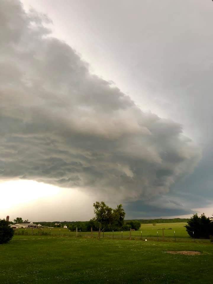
This was taken from brandy station (culpeper county) close to the fauquier county line. It certainly looks like a well defined supercell.
- 2,802 replies
-
- 4
-
-
- severe
- thunderstorms
- (and 4 more)
-
2019 Mid-Atlantic Severe Wx - General Discussion
jewell2188 replied to Kmlwx's topic in Mid Atlantic
Just drove through the town of Warrenton some pretty sizable branches sheared off of trees all within less than a half mile radius. Lots of flash flooding though. -
2019 Mid-Atlantic Severe Wx - General Discussion
jewell2188 replied to Kmlwx's topic in Mid Atlantic
Fake picture or not, i for the life of me can’t understand why or what satisfaction people get from posting photoshopped pictures.- 2,802 replies
-
- 3
-
-
- severe
- thunderstorms
- (and 4 more)
-
2019 Mid-Atlantic Severe Wx - General Discussion
jewell2188 replied to Kmlwx's topic in Mid Atlantic
All sun in Springfield since early this morning. Quite warm out. -
2019 Mid-Atlantic Severe Wx - General Discussion
jewell2188 replied to Kmlwx's topic in Mid Atlantic
Tired of slight risk!! When was the last enhanced or mod risk we had ?? -
2019 Mid-Atlantic Severe Wx - General Discussion
jewell2188 replied to Kmlwx's topic in Mid Atlantic
Incredibly weak in warrenton. Hardly no lightning or thunder....on to the next. -
2019 Mid-Atlantic Severe Wx - General Discussion
jewell2188 replied to Kmlwx's topic in Mid Atlantic
Seems interesting bc you seem to be hugging the GFS -
Deff mixing with sleet in falls church
-
Pretty cool!!

-
Radar confirms this. All sleet in Warrenton va. It’s moving pretty quickly northward.
-
Roads caved so fast, makes you think even harder about the waste of tax payer dollars to pretreat roads.....rant over
-
Ripping in falls church.
-
So to the untrained eye, are we going to be looking at the radar to the south for precip to start filling back in?