

qg_omega
-
Posts
3,053 -
Joined
-
Last visited
Content Type
Profiles
Blogs
Forums
American Weather
Media Demo
Store
Gallery
Posts posted by qg_omega
-
-
On 11/4/2023 at 1:32 PM, forkyfork said:
Finally a real post about this upcoming classic strong east based Nino
-
 1
1
-
 1
1
-
-
Zzzzz this month
-
1
-
-
Strangely cold in SI

-
2
-
-
7 hours ago, CoastalWx said:
Looks rather mundane overall after cold shot around Veterans Day. EPS has a GOAK trough, but some signs of an Aleutian low perhaps trying to build at the tail end of the run. That wouldn’t be a bad thing heading into late Monday and December.
Already backing off on the cold, likely these were the coldest anomalies nationwide of the winter season
-
 4
4
-
2
-
-
2 hours ago, Fantom X said:
I got down to 22.6 IMBY this morning down here ( Salisbury NC) To put in perspective, my 2023 low was 22.1 in January..
Likely coldest of winter
-
1
-
-
28, much lower than forecasted

-
2
-
-
16 minutes ago, bwt3650 said:
whiteface slides?
Slides on right, Parons run on left
-
1
-
-
-
Not seeing a warm sector today
-
1
-
-
terrible weather today, over a half inch so far
-
3 hours ago, the_other_guy said:
Edit: We laughed at you getting hysterical over 4 days of warm weather.
") Also, 77.2 in Westchester. Still havent hit 80
Also, 77.2 in Westchester. Still havent hit 80  in this stretch
HPN hit 80
-
1
-
-
Records all around, those who laughed at 80s earlier this week, lol

-
What time rain on Sunday? Record warmth tomorrow and Saturday
-
19 minutes ago, the_other_guy said:
44F in Southern Westchester this morning
Normal low for this time of year
-
8 hours ago, the_other_guy said:
well, you guys are a little crazy on this forum with this 4 days of 70s. Never mind that it’s freezing out right now.
I think this forum becomes an echo chamber sometimes were narratives get amplified to extremes
Record warmth is record warmth
-
1
-
-
Hello last winter:

-
Record warmth upcoming:
Expecting near record warmth mid to late week, as H5 heights reach 588 dm on Thu with H5-10 thicknesses at least 567 dm Thu-Sat. For temps took a 12Z GFS MOS/00Z ECMWF MOS blend for the most part which for the most part was even warmer than the NBM 75th percentile...with some modest downslope component to the flow (WSW) can`t see why some spots west of NYC wouldn`t push 80 for highs on at least Thu. -
5 hours ago, bluewave said:
Looks like the CPC is going with the Euro seasonal which has the warm Nino +PNA ridge to the north undercut by the -PDO trough near the southern Rockies. With a +PDO El Niño the trough would be over the Southeast. But it’s pulled west due to the -PDO in the seasonal forecasts. If we see the same error as the seasonal forecasts last winter, then the trough out West will be deeper pumping the ridge more in the East.
You can see the Euro seasonal maintaining the Niña -PDO ridge north of Hawaii. But it also has the Nino +PNA ridge in Canada. Need to lose the -PDO and ridge north of Hawaii for the El Niño to be able to be the main driver.

Classic Nino temp pattern
-
52 minutes ago, Brian5671 said:
That's actually the night before
here's 8pm Halloween night

Terrible lol
-
1 hour ago, bluewave said:
We get the highs approaching 80° while Montana goes below 0°. Same old pattern of recent years with the cold dumping into the West. Plenty of time for the cold to moderate coming east. But we’ll still probably get 30s around NYC which will feel much colder following 80°.


Great Halloween for the kids

-
80 looks likely
-
1
-
-
9 hours ago, so_whats_happening said:
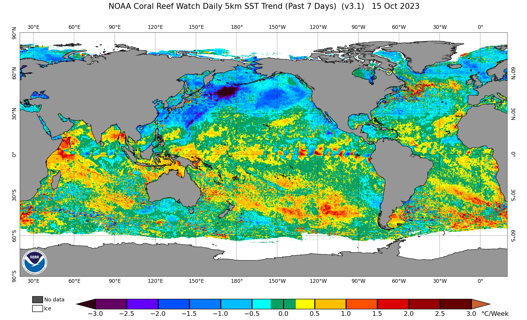
This should help with getting a more consistent look of an Aleutian low while waters off Japan are still cooling they are cooling much less than it has been, long ways to go it seems for destroying the -PDO but we should see a nice tick down for the monthly number.


Classic east based Nino
-
4
-
-
12 minutes ago, Allsnow said:
More cold for Montana
New run looks like the winter pattern with the trough out west, same old pattern
-
1
-
-
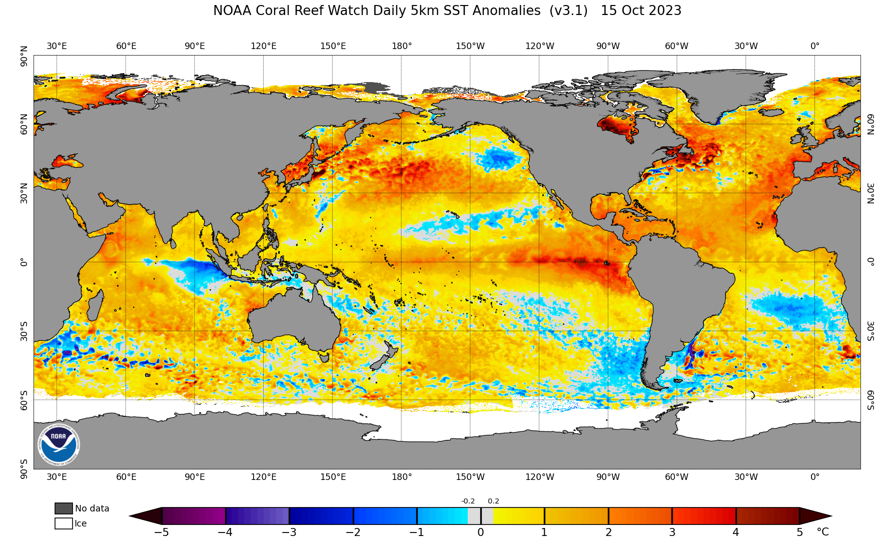
2 hours ago, bluewave said:
The Northeast is on track for another warmer October. Some parts of Maine are close to +10. Next few weeks look like more of the same.


Country flooded with warmth, classic Nino winter incoming
-
1
-
1
-


2023-2024 Winter/ENSO Disco
in New England
Posted
Brutal December look, full stop