
homedis
-
Posts
787 -
Joined
-
Last visited
Content Type
Profiles
Blogs
Forums
American Weather
Media Demo
Store
Gallery
Everything posted by homedis
-
Downtown chicago here… beating a dead horse but would much rather be on the northern fringe than the southern fringe of the defo axis for this one, especially with the warm lake. This one’s either gonna be nothing or a nice 5-6” imo.
-
Getting some light showers downtown lol
-
Gotta love to hate the lake
-
It wasnt. Yeah this things gonna ride the instability gradient just to the south of Chicago. Kankakee special
-
“Cool layer” I can barely breathe downtown Chicago right now its still 86/75
-
Lots of clearing coming - I have a good feeling about today.
-

2023 Short/Medium Range Severe Weather Discussion
homedis replied to Chicago Storm's topic in Lakes/Ohio Valley
At 6:23 saw the end of the Stickney cell https://imgur.com/a/fZAieiG -
2023 Short/Medium Range Severe Weather Discussion
homedis replied to Chicago Storm's topic in Lakes/Ohio Valley
Agreed, but I think its only a matter of when & where the storms interact with that warm front and instability that is heading northwards. -
2023 Short/Medium Range Severe Weather Discussion
homedis replied to Chicago Storm's topic in Lakes/Ohio Valley
Clouds thinning out already in loop area. I usually have no faith in strong severe after atmosphere mixing and stabilization this late in the day, but will be interested to see if SPC/forecast models are onto something. -
Warned for 90 mph Kendall and Kane Counties in IL
-
There's no way this last line can miss Chicago now... right? right?? Unless we get the I-39 special where the line hits a wall
-
Downtown Chicago in the screwhole for round 1
-
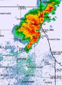
Getting a little concerned for Peoria based on the hook developing on that cell.
-
Tornado warnings starting to pop up now... here we go
-
Just measured 65/51 in downtown Chicago, this is definitely overperforming versus what the models were predicting.
-
Seems like SPC either doesnt like far NE IL for sig. wind/tornadoes or is deliberately trying to avoid showing the moderate risk over the lake And with NE storm motion (not SE) the boundaries seem a bit confusing to me.
-
Interesting that the MO storms seem to have fizzled out/coverage is less than modeled.
-
Been too long since we have had a set up not be limited by daytime clouds and/or convection. Today definitely doesn't feel like one of those days.
-
95% issuance of tornado watch in N 3/4 of Missouri and far W Central IL per SPC MD #388 for this morning cluster just exiting Kansas. Will be interesting to see how this plays out, will this wave be the main show for N IL? Are the dynamics of this system strong enough to recover quickly for the primary threat? Time will tell! Also to note, am already seeing peeks of sun here in Chicago.
-
I-290/Loop special right now with this band its rockin here in W. Loop
-
Winter 2022/23 Short/Medium Range Discussion
homedis replied to Chicago Storm's topic in Lakes/Ohio Valley
That was a top tier squall. https://imgur.com/a/gzNlfyt -
Pre-Christmas (Dec 21-23rd) Winter Storm Part 2
homedis replied to Chicago Storm's topic in Lakes/Ohio Valley
Let's keep that radar filling in with mod snow all evening -
Pre-Christmas (Dec 21-23rd) Winter Storm Part 2
homedis replied to Chicago Storm's topic in Lakes/Ohio Valley
As soon as the winds picked up here, the flakes are clearly getting pulverized to pixie dust -
Pre-Christmas (Dec 21-23rd) Winter Storm Part 2
homedis replied to Chicago Storm's topic in Lakes/Ohio Valley
Super decent sized flakes here in N Cook County w dusting on the ground already. Ready to b buried in 5" of snow -
Pre-Christmas (Dec 21-23rd) Winter Storm
homedis replied to Chicago Storm's topic in Lakes/Ohio Valley
Love the GFS just dancing around the ECMWF


