
homedis
-
Posts
787 -
Joined
-
Last visited
About homedis

Recent Profile Visitors


-

1/30-1/31 Lake Effect Snow Threat - SE WI, NE IL, and NW IN
homedis replied to A-L-E-K's topic in Lakes/Ohio Valley
Was just looking at that. It really likes the IL/IN border... its gonna be really close for downtown. I don't mind the oscillating if that means more widespread 6-10" rather than one place getting 18". -
1/30-1/31 Lake Effect Snow Threat - SE WI, NE IL, and NW IN
homedis replied to A-L-E-K's topic in Lakes/Ohio Valley
The "additional details" section clears it up. WWA covers the initial burst, WSW covers Friday evening with the main band. ADDITIONAL DETAILS...A burst of accumulating snow is expected mid to late Friday morning through early afternoon. The snow during this period may briefly fall at a rate of up to an inch per hour and make for slick travel conditions. Then, later Friday afternoon and evening, an intense band of heavy lake effect snow will develop over southern Lake Michigan, and may impact portions of central and southern Cook county near the lake for a period Friday evening before focusing eastward into northwestern Indiana later Friday night. While the residence time of this lake effect band over Cook county may only be 3 to 5 hours, the potential for heavy snow rates of 2+ inches per hour could result in localized accumulations exceeding 6 inches, particularly near the lake from the city southward. -
1/30-1/31 Lake Effect Snow Threat - SE WI, NE IL, and NW IN
homedis replied to A-L-E-K's topic in Lakes/Ohio Valley
Yeah looks like its gonna be mostly Lake Co, IN and Porter Co, but time will tell. If that band sits just a few miles to the west of where models are showing it, we could still be in play for more significant totals. Agree 2-3" is a good expectation at this time. -
1/30-1/31 Lake Effect Snow Threat - SE WI, NE IL, and NW IN
homedis replied to A-L-E-K's topic in Lakes/Ohio Valley
Agree with all on this. It’s really the more disorganized lake effect/lake enhancement scenarios that we really cash in, these single intense lake effect band scenarios take a lot of luck on this side of the lake. Low expectations but high ceiling for sure. -
1/24-1/25 Major Winter Storm - S. IL, IN, and OH
homedis replied to A-L-E-K's topic in Lakes/Ohio Valley
Averaging around 8.75” snow depth. Probably reached 10” storm total if I measured and wiped clean every few hrs since this was such a long event. -
1/24-1/25 Major Winter Storm - S. IL, IN, and OH
homedis replied to A-L-E-K's topic in Lakes/Ohio Valley
5.6” and still cranking, I’m super impressed. Is this what it regularly feels like to be on the east side of the lake? Lol -
1/24-1/25 Major Winter Storm - S. IL, IN, and OH
homedis replied to A-L-E-K's topic in Lakes/Ohio Valley
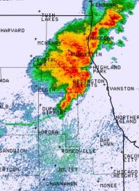
Even outside of the main “band” it seems like we’re getting some enhanced returns throughout cook county lakeshore. Even if an average of these rates can keep up until Sunday afternoon, it would be a decent hit for downtown. Around 1.5” so far ~2mi from the lake. -
1/24-1/25 Major Winter Storm - S. IL, IN, and OH
homedis replied to A-L-E-K's topic in Lakes/Ohio Valley
Still migrating west a bit, has the looks of an Evanston/Wilmette special. But its definitely east of where most hi-res guidance was placing it at this point. -
Nov 28-30th Post Turkey Day Winter Storm
homedis replied to Chicago Storm's topic in Lakes/Ohio Valley
Woke up this morning to a foot in Lake Forest. Best winter storm since Feb 2021 hands down! -
Nov 28-30th Post Turkey Day Winter Storm
homedis replied to Chicago Storm's topic in Lakes/Ohio Valley
Up to 10” snow depth, if I measured hourly and wiped a board clean each time I’m sure we’d be at 12” total accumulation. Best welcome to winter! -
Nov 28-30th Post Turkey Day Winter Storm
homedis replied to Chicago Storm's topic in Lakes/Ohio Valley
Just about 7.5” here in Lake Forest, some of the best dendrites all day right now. -
Nov 28-30th Post Turkey Day Winter Storm
homedis replied to Chicago Storm's topic in Lakes/Ohio Valley
6” and going. Bit of a dry slot coming in but looks like we still have 6”+ to go if HRRR is accurate. I think a foot may be within reach for most of Chicagoland. -
Nov 28-30th Post Turkey Day Winter Storm
homedis replied to Chicago Storm's topic in Lakes/Ohio Valley
0.5” here in Lake Forest. About as expected thus far! -
Nov 28-30th Post Turkey Day Winter Storm
homedis replied to Chicago Storm's topic in Lakes/Ohio Valley
From what I see on most guidance, it’ll increase QPF but will also reduce the ratios due to the warmer lake waters, so it’s almost a net zero. Not sure what will actually happen -
Nov 28-30th Post Turkey Day Winter Storm
homedis replied to Chicago Storm's topic in Lakes/Ohio Valley
Interesting, they even mention lake enhancement. Doesn’t match up with LOT at all. Edit: looking at it again, its actually matches up. Just a really odd look to the LOT map with the 5-9” stripe in the heart of Cook County.


