Blizzard of 93
-
Posts
12,868 -
Joined
-
Last visited
Content Type
Profiles
Blogs
Forums
American Weather
Media Demo
Store
Gallery
Everything posted by Blizzard of 93
-
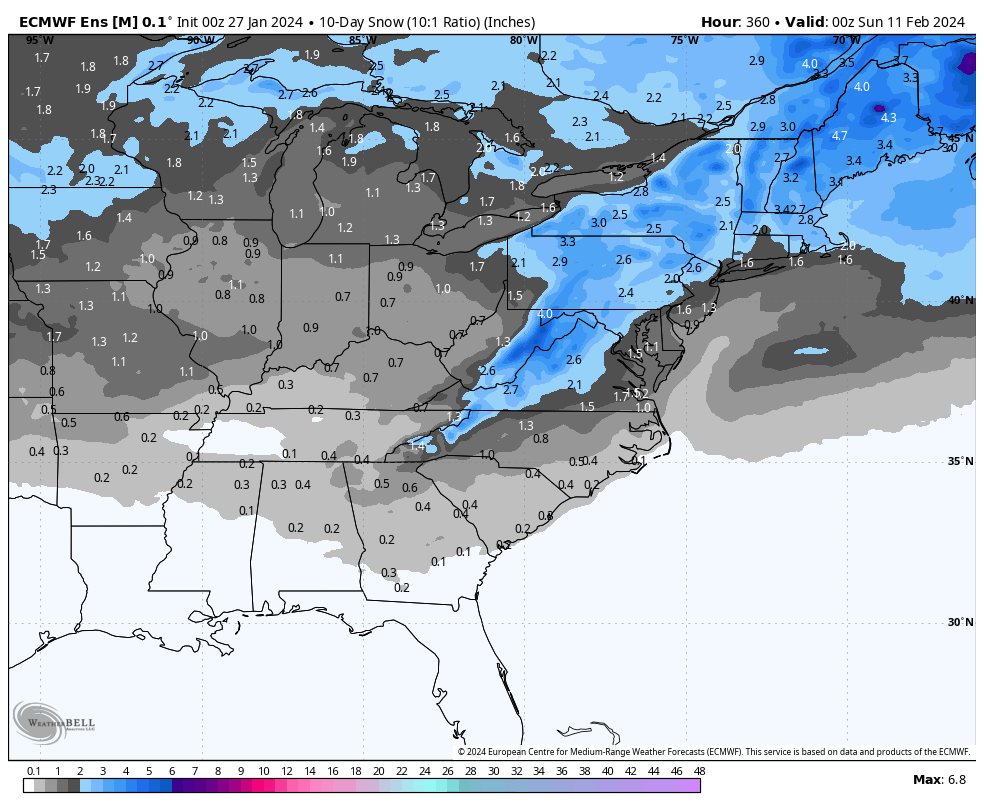
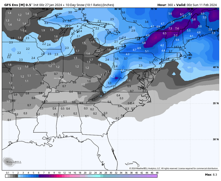
Just to show the growing potential for early February, the snow maps on the 0z GEFS & EPS are improving for the period of the first 10 days of the month.

-
The 0z EPS & 0z GEFS agree that a better pattern is coming as well. Here are their patterns for the week of February 3rd to 10th.
-
Yes, lots of time for the convoluted blocking & confluence to ease in the next 10 days. Better now to see it off of the Carolina coast instead of a low in the Lakes at this range.
-
6z GFS keeps alive the chance at some back end snow even for the LSV by Sunday evening.
-
Wow! Another 70 point night in the NBA this week.
-
Lol, no red tag here, but I love his posts. Brooklyn really knows his stuff & I’ve been learning more about pattern recognition & development from him. He has been having great post after great post today in the Mid Atlantic thread. It’s good to see PSU Hoffman fired up about the February potential as well.
-
12z EPS & 12z GEFS in the day 10 to 15 also are in agreement with the ridging shifting to central Canada & Alaska. The trough is undercutting and connecting the SW trough with the Atlantic trough. We should begin to have our chances if this look continues to hold.
-
6z GFS gets the initial low almost to the southwest PA border before the transfer off of the DelMarVa. This run gives a good chunk of CTP a chance at some backside snow. This is the Kuchera map. Hopefully the blue fills in by game time.
-
6z NAM gets decent snow this run to areas just to the north & west of Harrisburg.
-
My yard likes this map!
-
The 0z NAM does not have a primary that gets to Erie. The reason that CTP does so well this run is because the initial low is weak & does not plow too far north. The low then jumps to the coast well to our south in NC & then heads to the DelMarVa.
-
Speaking of things some of us are looking forward to… May I put in a request for you to do a “Day in the Life” of our CTP thread when you get the chance?
-
18z GFS was close for the LSV for Sunday despite the initial low tracking to northern WV before jumping the low to off of the DelMarVa. If the initial low dies in southern WV & then jumps to the coast, southern PA could get in on more snow potentially. As it stands now, northern LSV back north & west in CTP could be in for a decent snow chance if this run would verify.
-
Great to see the active pattern with more cold air around. We should have our chances in February
-
I am rooting for the @mitchnick storm on Sunday & the @Bubbler86 storm next week! Let’s go 2 for 2 in what was supposed to be a blind shutting week.
-
My handbook says to take the average of the 46 day mean & Control…. Based on this sound reasoning, I am expecting about 30 more inches at MDT by March!
-
I just looked at the 6z NAM & I like how far south the snow is showing before the coastal gets going at the end of the run.
-
We need a lot to go right for this event to work out, but at least we have a chance.
-
The full 6z GFS looks loaded with opportunities to score over the next 2 weeks. If that look holds, we should have chances.
-
Long way to go & at least we are in the game in what we originally thought would be a lost week for any chance.
-
6z Euro has a decent coastal low position. If there are good rates & you have a little elevation, some could score a little snow out of this.
-
Yes, the 6z GFS is very nice for all of CTP. The High is in a good spot up in Quebec It is the best run since the Euro yesterday. This will be very interesting to watch the models today & tomorrow as hopefully consensus builds.
-
Long way to go…soon we can add the RGEM & NAM to the mix.
-
I think the key will be to weaken the primary before WV & then jump the low to the coast in the DelMarVa.
-
Here is more from the 18z EPS with the mean low position & 6 hr. precip. I like that low position off of the coast of the DelMarVa.