

Blizzard of 93
-
Posts
13,037 -
Joined
-
Last visited
Content Type
Profiles
Blogs
Forums
American Weather
Media Demo
Store
Gallery
Everything posted by Blizzard of 93
-
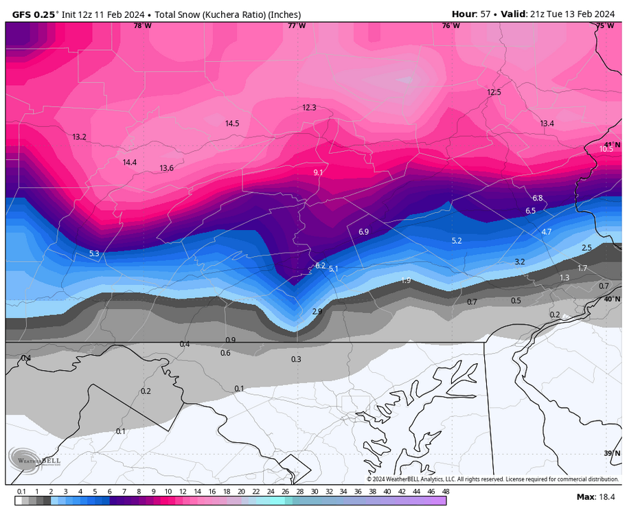
Selinsgrove PA went from 0 at 6z to 10 inches at 18z …
-
Yes, but Significant shift south from 6z to 18z Icon. 6z top 18z bottom
-
CTP freshened up the Watch & bumped amounts up again. I liked that they mentioned the 2 to 4 hour heavy snow potential Tuesday am.
-
Winter Storm Watch URGENT - WINTER WEATHER MESSAGE National Weather Service State College PA 249 PM EST Sun Feb 11 2024 PAZ025>028-034-056-057-059-121000- /O.CON.KCTP.WS.A.0003.240213T0400Z-240213T1800Z/ Blair-Huntingdon-Mifflin-Juniata-Bedford-Perry-Dauphin-Lebanon- Including the cities of Altoona, Huntingdon, Mount Union, Lewistown, Mifflintown, Bedford, Newport, Harrisburg, Hershey, and Lebanon 249 PM EST Sun Feb 11 2024 ...WINTER STORM WATCH REMAINS IN EFFECT FROM MONDAY EVENING THROUGH TUESDAY AFTERNOON... * WHAT...Heavy snow possible. Total snow accumulations of 3 to 6 inches possible. * WHERE...Portions of south-central Pennsylvania. * WHEN...From Monday evening through Tuesday afternoon. * IMPACTS...Plan on slippery road conditions. The hazardous conditions could impact the morning commute. * ADDITIONAL DETAILS...Rain will develop Monday evening and turn to snow overnight into early Tuesday morning. Snow will continue through the early afternoon hours. A two-to-four hour period of heavy snow is possible around daybreak Tuesday when snowfall rates of one to two inches per hour could occur.
-
3k NAM best run yet, but not nearly as generous as the 12k. I wouldn’t complain about the 5 it shows around Harrisburg.
-
Lol, I’d be happy with half of this!
-
Serious & thoroughly satisfying NAMing!
-
These are the 12z ensemble snow maps for day 5 through 15. These do NOT include the current early week storm. This is a great general signal for active pattern with chances in this day 5 through 15 period.
-
Beautiful!
-
Exactly, I feel we will be busy in here through mid March.
-
The 12z EPS joined the other 12z ensembles & also has higher snow amounts for the LSV with now getting the 4 inch line to Harrisburg. This is is best EPS run since early yesterday.
-
The Euro looks close to me to having a bit more snow in the LSV with the 540 line crashing with heavier precip still overhead & the low position offshore as of 12z Tuesday. The short range higher res models should help to resolve this area closer to storm time.
-
12z Euro slight improvement for the LSV over its last couple of runs, but still has less than latest GFS & Canadian in the LSV. The rest of CTP further north & west of Harrisburg still do well this run.
-
From CTP… ”A deepening low pressure system lifting out of the Gulf Coast will track across Delaware and the southern tip of New Jersey Monday night into early Tuesday bringing a Moderate to heavy snowfall across much of Central and Northern PA, while a longer period of rain for the first half of the storm leads to a slushy coating to few inches across the region east of Interstate 83 and south of the PA Turnpike.”
-
12z GEFS & 12z GEPS both brought the snow line further south than their previous run. Both now get 4.7 to Harrisburg by Tuesday evening.
-
12z Canadian similar low position as the GFS.
-
Despite being told it’s over last night & that me & apparently CTP were wishcasting….. The 12z GFS had Warning snow for the Harrisburg area on to the north.
-
CTP refreshed the Watch overnight but did mention at the end that they may cancel the Watch if amounts continue to drop in southern PA.
-
Winter Storm Watch URGENT - WINTER WEATHER MESSAGE National Weather Service State College PA 338 AM EST Sun Feb 11 2024 PAZ025>028-034-056-057-059-112045- /O.CON.KCTP.WS.A.0003.240213T0400Z-240213T1800Z/ Blair-Huntingdon-Mifflin-Juniata-Bedford-Perry-Dauphin-Lebanon- Including the cities of Altoona, Huntingdon, Mount Union, Lewistown, Mifflintown, Bedford, Newport, Harrisburg, Hershey, and Lebanon 338 AM EST Sun Feb 11 2024 ...WINTER STORM WATCH REMAINS IN EFFECT FROM MONDAY EVENING THROUGH TUESDAY AFTERNOON... * WHAT...Heavy snow possible. Total snow accumulations of 2 to 5 inches possible. * WHERE...Portions of central Pennsylvania. * WHEN...From Monday evening through Tuesday afternoon. * IMPACTS...Plan on slippery road conditions. The hazardous conditions could impact the morning commute. * ADDITIONAL DETAILS...Rain will turn to snow through the night Monday night and early Tuesday. The storm track is now expected to be slightly farther north. This should allow the precipitation to stay rain for longer during the storm. Thus, snowfall totals are expected to be less than earlier forecasts for southern PA. The watch may be cancelled if the expected snow amounts continue to drop.
-
6z EPS & 6z GEFS still keep the LSV in the game for Advisory snow & still have Warning snow for the northern half of CTP.
-
6z NAM still looks good with a coastal low track a little further offshore. It brings 3 to 4 down to even Rouzerville & Hanover.
-
6z GFS gets Advisory snow to Harrisburg & Warning snow further north on CTP.
-
0% was directed at you good sir! The visiting pot stirring posters set me off & being called a disrespectful wishcaster by that one dude put me on edge to say the least.
-
Here is some of CTP’s latest Forecast discussion: ”LONG TERM /MONDAY THROUGH SATURDAY/... KEY MESSAGES: * Increasing potential for plowable to possibly heavy snow Monday night into early Tuesday (February 12-13th) * A Winter Storm Watch has been issued for portions of central Pennsylvania Monday evening through Tuesday afternoon. * Some uncertainty still exists on the western fringe and across southern PA, where the placement of the low could allow for longer periods of rain, lowering snowfall totals. All medium range guidance phases a potent southern stream shortwave with the northern branch of the jet early Tuesday, as if lifts northeast from the Miss Valley. The bulk of model guidance tracks the associated deepening surface low just south of PA and off the Delmarva Peninsula by early Tuesday morning, placing much of Central PA in the bullseye for the heaviest precipitation associated with strong warm advection and upper level diffluence north of the low track. A dual jet streak structure favors a region of enhanced fgen forcing in this region north of the low track. Model cross section analyses are also indicating a good instability signature between 06Z-12Z Tuesday, with a layer of negative EPV located in the layer just above the frontogenesis. This scenario supports the potential of intense banding somewhere over Central or Southern PA late Monday night. As for ptype, model consensus currently points to an initial rain/snow mix changing to snow late Monday night in association with dynamic cooling initially, then cold advection on the northwest periphery of the exiting low. Although this scenario definitely supports the possibility for a period of heavy snow across a large portion of Central PA, there remains some significant model spread in the exact low track, which could alter exactly where the heaviest precipitation falls. The 18Z GEPS for instance tracks the surface low considerably further south, which could result in the heaviest precipitation falling over extreme Southeast PA with little over the northern half of the state. The current Winter Storm Watch highlights where model consensus currently supports the best chance of a 6+ inch snowfall. Locations to the north and west of the main swath will get less precip and thus less snow overall, while areas further south (closer to the low track) will have to contend with a longer period of rain before any changeover. Timing has become more clear with recent model guidance, suggesting the heaviest snow will fall during the predawn hours of Tuesday, with the most significant travel impacts expected for the Tuesday morning commute. Please stay tuned for updates to the forecast, as details continue to be ironed out in upcoming forecast cycles.”
-
Yes, just about 10 minutes away. Beautiful park there as well right along the river with scenic views.


