EHoffman
-
Posts
933 -
Joined
-
Last visited
Content Type
Profiles
Blogs
Forums
American Weather
Media Demo
Store
Gallery
Everything posted by EHoffman
-
Jebwalked up to cathedral heights, been puking the entire time. Definitely over 3” here
-
Roads have caved in AdMo
-
The real trick is to walk towards Cathedral Heights where all the roads cave and you can pretend the DC heat pump doesn't exist. Plus the church is pretty in the snow.
-
Don't I know it but starting to see some returns between CHO and here in the past hour which is a good sign. Right in line with NAM's timing thus far.
-
Yeah exactly we're gonna get our couple of inches when the sun goes down but we're not gonna accumulate like people up north during the day time. Tonight should be beautiful out.
-
If you try to compare DC metro snow with people out in Frederick you're gonna have a bad time. We'll get our couple of inches once the sun goes down and it'll be fine.
-
Steady snowtv for the past 90 mins here. Sidewalks and roads wet. Goes to show we literally need to be ripping to get any meaningful daytime accumulation in DC.
-
Heaviest of the light snow of the day just started here in Adams Morgan
-
Jan 15-16 Storm Threat Thread: The Return of Hope??
EHoffman replied to stormtracker's topic in Mid Atlantic
Nearing 3" by 03z Tuesday in DC -
Jan 15-16 Storm Threat Thread: The Return of Hope??
EHoffman replied to stormtracker's topic in Mid Atlantic
Hilarious how somehow NYC/PA is gonna beat us on this threat. -
Jan 15-16 Storm Threat Thread: The Return of Hope??
EHoffman replied to stormtracker's topic in Mid Atlantic
This generally seems like an event we can do well on. I'm just happy we don't have to battle with graupel. -
JUst got in from a nice long jebwalk. Just dumping the entire time, it was incredible. Prob like 5-6" and counting. Lots of trees down too.
-
It's white rain. Not sticking anywhere
-
Pretty impressed how far NW precipitation is spreading already.
-
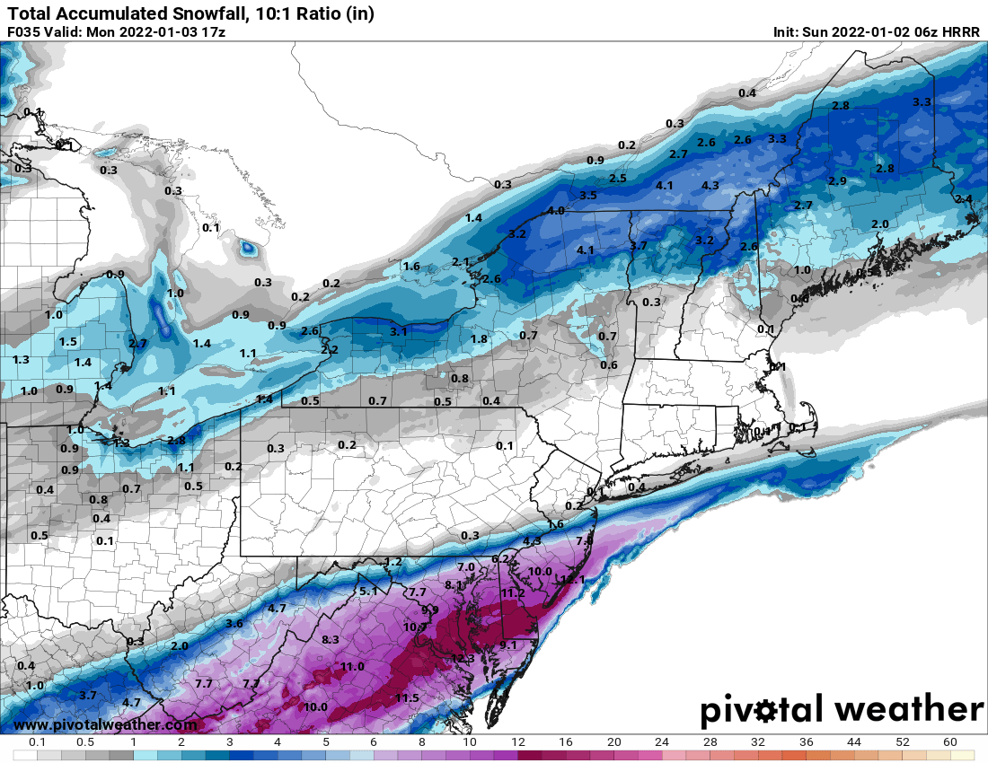
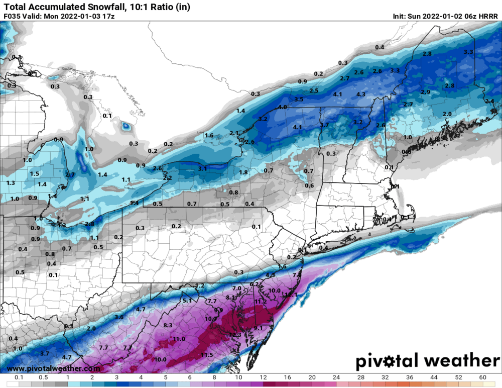
URGENT - WINTER WEATHER MESSAGE National Weather Service Baltimore MD/Washington DC 256 AM EST Mon Jan 3 2022 DCZ001-MDZ013-014-504-506-VAZ052>054-501-502-506-031600- /O.CON.KLWX.WS.W.0001.000000T0000Z-220103T2100Z/ District of Columbia-Prince Georges-Anne Arundel- Central and Southeast Montgomery-Central and Southeast Howard- Prince William/Manassas/Manassas Park-Fairfax- Arlington/Falls Church/Alexandria-Northern Fauquier- Southern Fauquier-Eastern Loudoun- 256 AM EST Mon Jan 3 2022 ...WINTER STORM WARNING REMAINS IN EFFECT UNTIL 4 PM EST THIS AFTERNOON... * WHAT...Heavy snow. Total snow accumulations 5 to 10 inches, with the heaviest amounts most likely near and south of US 50. * WHERE...The Washington Metropolitan area, portions of northern Virginia, and Washington DC. * WHEN...Until 4 PM EST this afternoon. Rain and sleet will change to all snow between 5 AM and 8 AM this morning. The heaviest snow will be through early this afternoon. * IMPACTS...Plan on snow covered and slippery roads, making travel difficult. The hazardous conditions will impact the morning commute. * ADDITIONAL DETAILS...Visibility will be reduced to below one- half mile at times in heavier bands of snow. I got my alarm set for 7 but I'm too excited to sleep
-
Starting to hear some pings in DC
-
Seems reasonable, literally always a concern around these parts. Doesn't help that it's still in the mid 40s. I'm just here for the 2"/hr rates post sunrise tho
-
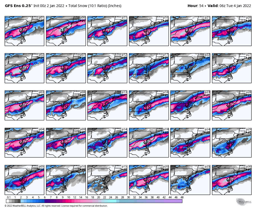
Looks more amped tho, I think it's just a little subsidence around DC metro but otherwise we still bank a foot. Good run.
-
HRRR pretty good I'd say
-
Since last year set the precedent of a constant NW march until gametime I feel like we're in a decent spot until we're not
-
I'd take 2" of graupel at this point
-
I'm no master baker but maybe it's a bit underproved...not that I wouldn't eat the hell outta this. Crust looks really nice too. Good job.
-
Cut it open and let's see that crumb structure.
-
Don't worry there will also be giant wasps eating them too https://en.wikipedia.org/wiki/Sphecius_speciosus