EHoffman
-
Posts
933 -
Joined
-
Last visited
Content Type
Profiles
Blogs
Forums
American Weather
Media Demo
Store
Gallery
Everything posted by EHoffman
-
2024 Valentines Day Who the Hell Knows - Comeback Thread
EHoffman replied to DDweatherman's topic in Mid Atlantic
Delete this -
2024 Valentines Day Who the Hell Knows - Comeback Thread
EHoffman replied to DDweatherman's topic in Mid Atlantic
We're so close. Now that it's in our sights I want it -
2024 Valentines Day Who the Hell Knows - Comeback Thread
EHoffman replied to DDweatherman's topic in Mid Atlantic
We a RAP board now? -
2024 Valentines Day Who the Hell Knows - Comeback Thread
EHoffman replied to DDweatherman's topic in Mid Atlantic
-
April 8th Eclipse- Last Easy One To See In My Lifetime
EHoffman replied to Interstate's topic in Mid Atlantic
I have a friend in Cleveland who I may go visit. Really I wanna buy a ton of eclipse glasses for cheap online and hawk them closer to the event. I remember last eclipse they were hard to come by and I paid like $10 for a pair. -
I just want a legitimate threat to track next week and this Euro run got me excited for that so mission accomplished.
-
I hate global warming so much guys
-
2024 Valentines Day Who the Hell Knows - Comeback Thread
EHoffman replied to DDweatherman's topic in Mid Atlantic
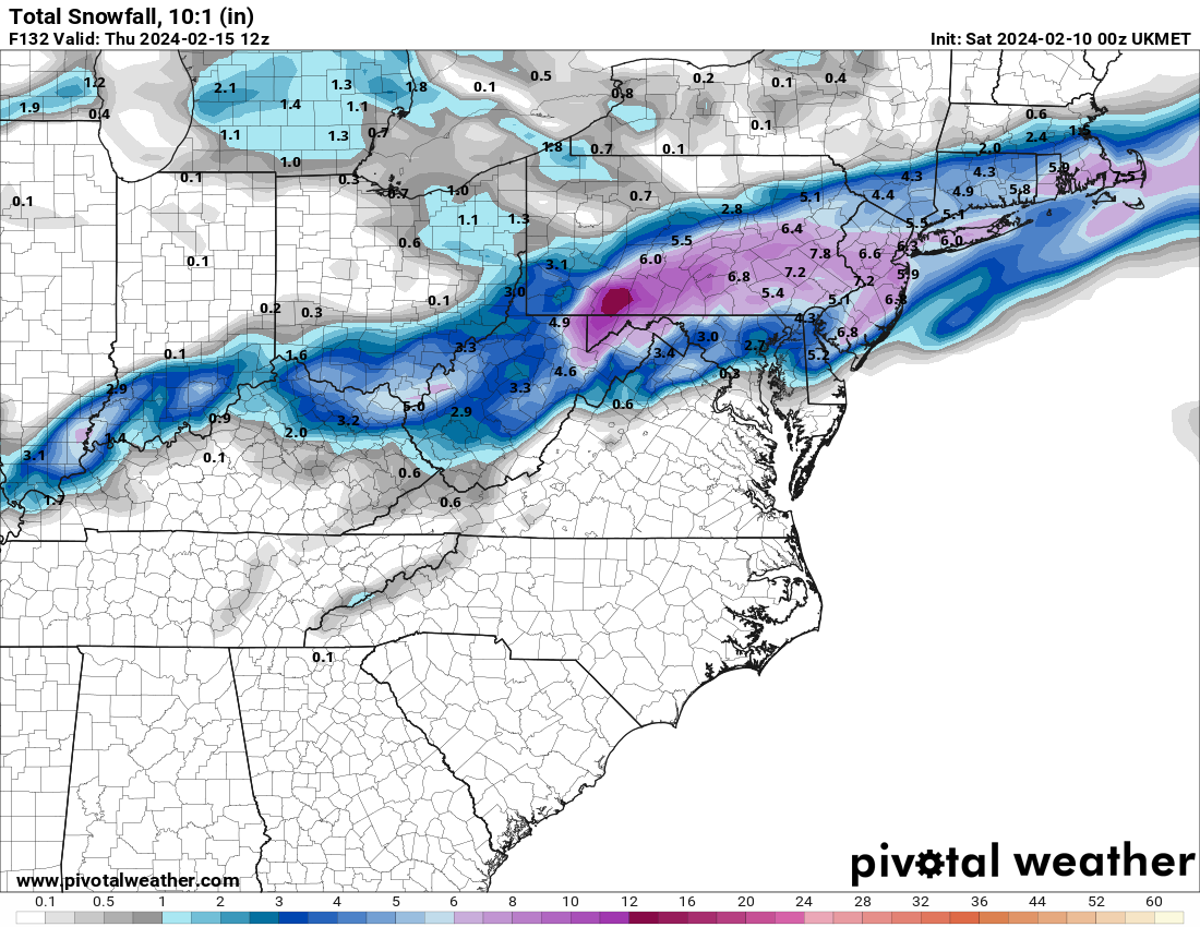
UKIE gets it close
-
2024 Valentines Day Who the Hell Knows - Comeback Thread
EHoffman replied to DDweatherman's topic in Mid Atlantic
12z Tuesday eh that's pretty good timing. -
2024 Valentines Day Who the Hell Knows - Comeback Thread
EHoffman replied to DDweatherman's topic in Mid Atlantic
It's 100% over for DC proper, maybe some white rain at the end. Northern parts of our region have a shot but the clock is definitely ticking. -
That was his name, right. Hilarious character.
-
The line about the guy who makes his own snow made me burst out loud laughing. Haven't thought about him in years.
-
2024 Valentines Day Rain/Snow/Who The Hell Knows Thread
EHoffman replied to WinterWxLuvr's topic in Mid Atlantic
Weren't you just complaining about this hobby in the other thread? -
2024 Valentines Day Rain/Snow/Who The Hell Knows Thread
EHoffman replied to WinterWxLuvr's topic in Mid Atlantic
Not too many hits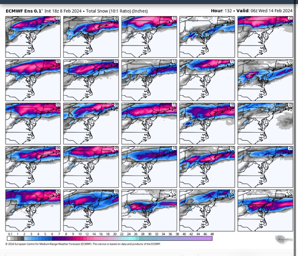
-
2024 Valentines Day Rain/Snow/Who The Hell Knows Thread
EHoffman replied to WinterWxLuvr's topic in Mid Atlantic
Toss it -
2024 Valentines Day Rain/Snow/Who The Hell Knows Thread
EHoffman replied to WinterWxLuvr's topic in Mid Atlantic
I was looking at 126, where we're also ripping. But yeah sfc gets to freezing relatively quickly. -
2024 Valentines Day Rain/Snow/Who The Hell Knows Thread
EHoffman replied to WinterWxLuvr's topic in Mid Atlantic
36 on the surface for our heaviest rates lol -
2024 Valentines Day Rain/Snow/Who The Hell Knows Thread
EHoffman replied to WinterWxLuvr's topic in Mid Atlantic
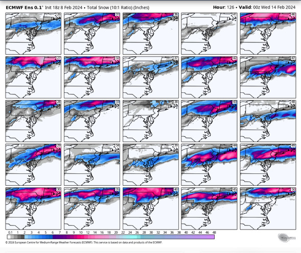
Hour 126 -
2024 Valentines Day Rain/Snow/Who The Hell Knows Thread
EHoffman replied to WinterWxLuvr's topic in Mid Atlantic
End of GEM has some nice looking potential. -
We went from 3 legit threats 3 days ago to now hoping the first two cutters don't fuck up the pattern for our alleged big dog in 3 weeks.
-
Not saying it won't be cold enough to snow, just that we're not gonna get cold smoke this late in the season, and with the sun angle being what it is we just need rates to get real accumulation. That even includes overnight precip, at least within DC. I'm not saying it's impossible, in fact I love the fact we're tracking bombs and big dogs and not some weak piddling stuff. That's what we need. But big snow in DC past mid-feb is always always an uphill battle.
- 2,509 replies
-
- 2
-

-
- weenie fest or weenie roast?
- weenies got roasted
- (and 2 more)
-
Rates rates rates is the name of the game around here once we get past mid-Feb. Temps are gonna be marginal no matter how you slice it.
-
That was one of the best weeks of winter we've had in years so I'll take it. Snow on snow was incredible.
- 2,509 replies
-
- 2
-

-
- weenie fest or weenie roast?
- weenies got roasted
- (and 2 more)
-
Start the storm thread boys
-
I actually don't disagree. I live up in Madison for winter 07-08 and they had a record 100" that winter, and by March that shit was more of a nuisance than enjoyable. But that was after like 4 straight months of snow cover.
- 2,509 replies
-
- 4
-
-
- weenie fest or weenie roast?
- weenies got roasted
- (and 2 more)