cincy.wx
-
Posts
107 -
Joined
-
Last visited
Content Type
Profiles
Blogs
Forums
American Weather
Media Demo
Store
Gallery
Everything posted by cincy.wx
-
tornado on ground, growing very fast.
-
95/90 probs. one of those kinds of days i suppose
-
-
april 14, 2012 out on the high plains. april 13's day 2 featured two separate high risks and then april 14 started out with two before they eventually became one.
-
not necessarily in this region of the forum but the southern end of the moderate will also be upgraded to high. significant day unfolding for a large part of the country.
-
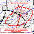
Mesoscale Discussion 0390 NWS Storm Prediction Center Norman OK 1037 AM CDT Fri Mar 31 2023 Areas affected...portions of southeastern Iowa...northwestern Illinois...and far northeastern Missouri Concerning...Outlook upgrade Valid 311537Z - 311630Z SUMMARY...Portions of the Moderate Risk over southeastern IA, northwestern IL, and far northeastern MO will be upgraded to a categorical High Risk in the 1630 UTC Convective outlook. DISCUSSION...An upgrade to a tornado-driven High Risk (30% probability) is expected for the 1630 UTC outlook. Environmental conditions are quickly becoming favorable to support the potential for numerous strong to potentially violent and long-track tornadoes across portions of southeastern IA, northwestern IL, and far northeastern MO. Please see the forthcoming Day 1 outlook update for more information. ..Lyons/Smith.. 03/31/2023
-
2023 Short/Medium Range Severe Weather Discussion
cincy.wx replied to Chicago Storm's topic in Lakes/Ohio Valley
ILN calling it a radar confirmed tornado now, heading northeast towards the dayton metro. spotter report from Germantown, OH: Source: AMATEUR RADIO UTC Valid: 2023-02-27T19:48:00ZRemark: POSSIBLE TORNADO FROM MULTIPLE SPOTTERS -
2023 Short/Medium Range Severe Weather Discussion
cincy.wx replied to Chicago Storm's topic in Lakes/Ohio Valley
miraculously nothing has been reported but that couplet passing east of brookville, IN does not want to quit EDIT: this could become a problem for the dayton metro within the next hour. -
2023 Short/Medium Range Severe Weather Discussion
cincy.wx replied to Chicago Storm's topic in Lakes/Ohio Valley
spotty sun out ahead of this one. -
2023 Short/Medium Range Severe Weather Discussion
cincy.wx replied to Chicago Storm's topic in Lakes/Ohio Valley
looks like there was a brief lil spinner about 15 miles northwest of KLOT -
2023 Short/Medium Range Severe Weather Discussion
cincy.wx replied to Chicago Storm's topic in Lakes/Ohio Valley
hrrr continues to bring more instability up to the ohio river. i think the tornado risk along the ohio river TP is being understated. cincy could very well get in on the action. -
2023 Short/Medium Range Severe Weather Discussion
cincy.wx replied to Chicago Storm's topic in Lakes/Ohio Valley
next weds/thurs could be interesting near and south of the ohio river... -
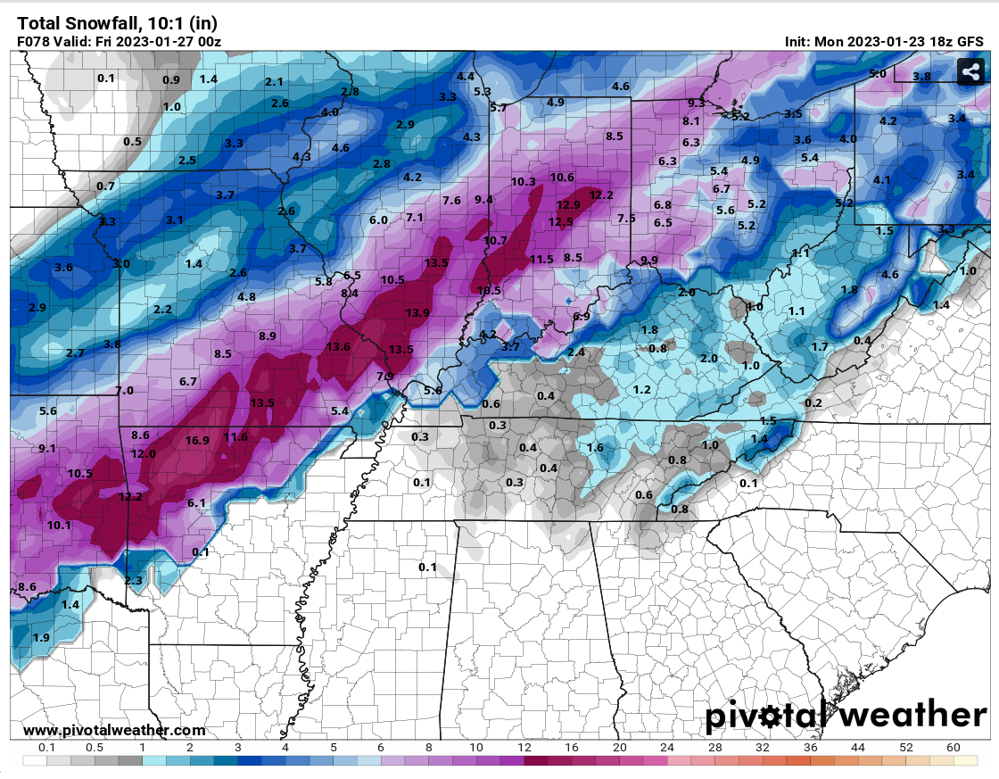
Midwest/Ohio Valley/Great Lakes Snow January 24-26
cincy.wx replied to Baum's topic in Lakes/Ohio Valley
thought we’d have rain for quite a bit longer but areas just SW of cincy are starting to see big flakes and sleet is beginning to fall inside the 275 loop … will be interesting to watch -
Midwest/Ohio Valley/Great Lakes Snow January 24-26
cincy.wx replied to Baum's topic in Lakes/Ohio Valley

-
Midwest/Ohio Valley/Great Lakes Snow January 24-26
cincy.wx replied to Baum's topic in Lakes/Ohio Valley
would love some more of it here in cincy but i have no room to complain thanks to sunday's surprise. local mets are steadily trying to raise awareness with each new model run but i dont want to bite yet. -
The Appetizer: Light Snow general 1-2 " event 1/22-1/23
cincy.wx replied to Baum's topic in Lakes/Ohio Valley
woke up to 5.5" on the ground yesterday morning, completely oblivious to the fact that it was supposed to snow. easiest 5.5" i've ever had to shovel, though, as it was the wet kind. I know a couple towns just west of Cincy saw 6"+ -
80/60 probs
-
11/29/22 MDT Outlook Issued -- Regional outbreak possible.
cincy.wx replied to CryHavoc's topic in Central/Western States
MS state trooper reported this; relayed by WLBT in Jackson, MS. live coverage: https://www.wlbt.com/livestream/ -
11/29/22 MDT Outlook Issued -- Regional outbreak possible.
cincy.wx replied to CryHavoc's topic in Central/Western States
low lcls + fast storm motion + strong tornadoes + nighttime + lack of general awareness is never what you want to see. -
Major November Outbreak Possible
cincy.wx replied to Tallis Rockwell's topic in Central/Western States
so, what’s keeping this from going off? -
Major November Outbreak Possible
cincy.wx replied to Tallis Rockwell's topic in Central/Western States
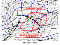
Mesoscale Discussion 1917 NWS Storm Prediction Center Norman OK 1128 AM CDT Fri Nov 04 2022 Areas affected...southeastern Oklahoma across north-central and northeastern Texas Concerning...Severe potential...Tornado Watch likely Valid 041628Z - 041730Z Probability of Watch Issuance...95 percent SUMMARY...Potential for severe/supercell storms is expected to gradually increase into the afternoon. All-hazards severe risk is expected, including likelihood for for significant tornadoes, widespread damaging winds, and large hail. A tornado watch will likely be required by early afternoon. DISCUSSION...Latest radar loop shows convection increasing in coverage/intensity along an advancing cold front now stretching from southeastern Kansas across central and southwestern Oklahoma and into western North Texas. Ahead of the front/frontal convection, a moistening boundary layer is indicated, with mid 60s dewpoints into southeastern Oklahoma and low 70s dewpoints now spreading toward the Dallas/Fort Worth Metroplex. The low-level moistening is occurring beneath a rather substantial capping inversion, revealed by the recent 15Z FWD RAOB, and which extends across the warm sector as suggested by the character of the low cloudiness as revealed by recent visible satellite imagery. This cloudiness will continue to retard heating, and thus low-level destabilization, over the next several of hours, but cooling aloft -- associated with the advancing upper system -- will allow gradual airmass destabilization, particularly above 700mb. Weak warm-advection-induced showery convection indicated across the warm sector continues to gradually increase, with some small/higher reflectivity cores beginning to become apparent. Expect a gradual ramp-up in this convection to continue -- with eventual growth into cellular/lightning-producing cells as cooling aloft continues within the capping layer and above. Once deep convection becomes established, rapid intensification to severe levels is expected, as very favorable shear -- provided by low-level southerly flow veering to south-southwesterly and increasing to 50 kt at around 1km along with additional veering above -- resides across the warm sector. Risk for strong/significant tornadoes will then ensue, as storms acquire strong rotation. Large hail and locally damaging winds are also expected. Risk for damaging winds will likely increase later this afternoon and beyond, as convection strengthens linearly along the front with time, likely merging gradually with pre-frontal cellular convection to evolve into a well-developed squall line by early evening. This anticipated evolution will likely require tornado watch issuance within the next hour or two, extending eastward across southeastern Oklahoma and North Texas toward the Arklatex region. ..Goss/Hart.. 11/04/2022 -
concerned about the north/northwest suburbs of chicago
-
2022 Short/Medium Range Severe Weather Discussion
cincy.wx replied to Chicago Storm's topic in Lakes/Ohio Valley
-
2022 Short/Medium Range Severe Weather Discussion
cincy.wx replied to Chicago Storm's topic in Lakes/Ohio Valley
-
2022 Short/Medium Range Severe Weather Discussion
cincy.wx replied to Chicago Storm's topic in Lakes/Ohio Valley
tornado on the ground northwest of springfield ohio. meanwhile, isolated tornado warnings are coming and going across the slight risk area