
AWMT30
-
Posts
320 -
Joined
-
Last visited
Content Type
Profiles
Blogs
Forums
American Weather
Media Demo
Store
Gallery
Everything posted by AWMT30
-

Winter 2025-26 Medium/Long Range Discussion
AWMT30 replied to michsnowfreak's topic in Lakes/Ohio Valley
GFS doing some wobbles back and forth with the Thursday Event. At least it still has it at this point. -
1/24-1/25 Major Winter Storm - S. IL, IN, and OH
AWMT30 replied to A-L-E-K's topic in Lakes/Ohio Valley
Small flakes are going to screw us over here in the area but still its gonna add up to near 6-7" A solid Winter Storm. -
1/24-1/25 Major Winter Storm - S. IL, IN, and OH
AWMT30 replied to A-L-E-K's topic in Lakes/Ohio Valley
Still light and fine snowflakes here closing in on 1" as of 630. Better radar returns are starting to head this way. Not expecting to see heavy snow rates here but would appreciate if the snow rate would pick up just a little bit. Good to see the CBus crew getting wrecked. -
1/24-1/25 Major Winter Storm - S. IL, IN, and OH
AWMT30 replied to A-L-E-K's topic in Lakes/Ohio Valley
You Cbus guys gonna get 12-15" -
1/24-1/25 Major Winter Storm - S. IL, IN, and OH
AWMT30 replied to A-L-E-K's topic in Lakes/Ohio Valley
What a smack job on the 6z HRRR... Snow has started here with a good dusting so far. -
1/24-1/25 Major Winter Storm - S. IL, IN, and OH
AWMT30 replied to A-L-E-K's topic in Lakes/Ohio Valley
When you step outside this evening if has that Winter Storm smell to the air. I am ready 2 be buried! -
1/24-1/25 Major Winter Storm - S. IL, IN, and OH
AWMT30 replied to A-L-E-K's topic in Lakes/Ohio Valley
Incoming Hit on SE Michigan on the 18z HRRR -
1/24-1/25 Major Winter Storm - S. IL, IN, and OH
AWMT30 replied to A-L-E-K's topic in Lakes/Ohio Valley
Christ I was kidding... I live in SE Michigan and we get burned all the time on weather events here it sucks when you do all this tracking and then boom it slips away from you. I feel for them... Anyways let's have a great 18z model suite. -
1/24-1/25 Major Winter Storm - S. IL, IN, and OH
AWMT30 replied to A-L-E-K's topic in Lakes/Ohio Valley
Another solid Euro run for the Detroit Metro I better watch what say LOL -
1/24-1/25 Major Winter Storm - S. IL, IN, and OH
AWMT30 replied to A-L-E-K's topic in Lakes/Ohio Valley
Zero tears shed for anyone on the EC.... Now tears of laughter absolutely love seeing them get pingers instead of a Big Dog. -
1/24-1/25 Major Winter Storm - S. IL, IN, and OH
AWMT30 replied to A-L-E-K's topic in Lakes/Ohio Valley
SEESH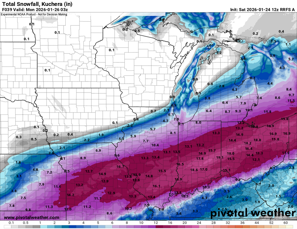
-
1/24-1/25 Major Winter Storm - S. IL, IN, and OH
AWMT30 replied to A-L-E-K's topic in Lakes/Ohio Valley
Yeah we are in a pretty good spot here hopefully. -
1/24-1/25 Major Winter Storm - S. IL, IN, and OH
AWMT30 replied to A-L-E-K's topic in Lakes/Ohio Valley
NAM looks north again. -
1/24-1/25 Major Winter Storm - S. IL, IN, and OH
AWMT30 replied to A-L-E-K's topic in Lakes/Ohio Valley
Yeah thinking Lenawee, Monroe, and Wayne should go Warning -
1/24-1/25 Major Winter Storm - S. IL, IN, and OH
AWMT30 replied to A-L-E-K's topic in Lakes/Ohio Valley
Leave us out it made the models come back north haha -
1/24-1/25 Major Winter Storm - S. IL, IN, and OH
AWMT30 replied to A-L-E-K's topic in Lakes/Ohio Valley
18z Euro going to be north -
1/24-1/25 Major Winter Storm - S. IL, IN, and OH
AWMT30 replied to A-L-E-K's topic in Lakes/Ohio Valley
Nice write up there brother hope you are doing well down there in the Great State of Ohio!!! -
1/24-1/25 Major Winter Storm - S. IL, IN, and OH
AWMT30 replied to A-L-E-K's topic in Lakes/Ohio Valley
Call of 7" here. -
1/24-1/25 Major Winter Storm - S. IL, IN, and OH
AWMT30 replied to A-L-E-K's topic in Lakes/Ohio Valley
Euro with another bounce North at 6z. -
1/24-1/25 Major Winter Storm - S. IL, IN, and OH
AWMT30 replied to A-L-E-K's topic in Lakes/Ohio Valley
Let's reel this in!! -
Winter 2025-26 Short Range Discussion
AWMT30 replied to SchaumburgStormer's topic in Lakes/Ohio Valley
Yeah we did do well here in Canton with 5.5" -
Nov 28-30th Post Turkey Day Winter Storm
AWMT30 replied to Chicago Storm's topic in Lakes/Ohio Valley
Gonna be funny with SE Michigan with an advisory and Toledo under a Winter Storm Warning, -
Nov 28-30th Post Turkey Day Winter Storm
AWMT30 replied to Chicago Storm's topic in Lakes/Ohio Valley
Classic weaken trend as it moves into the state? -
Nov 28-30th Post Turkey Day Winter Storm
AWMT30 replied to Chicago Storm's topic in Lakes/Ohio Valley
Solid start to the models today! A nice Chicago to Detroit sweeping Winter Storm with 6-10" -
Detroit Rock City


