Buffalo Bumble
-
Posts
1,613 -
Joined
-
Last visited
Content Type
Profiles
Blogs
Forums
American Weather
Media Demo
Store
Gallery
Posts posted by Buffalo Bumble
-
-
Anyone have the Canadian? Not loading on TT.
-
Seriously 18Z GFS??
-
 1
1
-
-
40 minutes ago, tim123 said:
Finally get a pattern change and still no synoptic storms. We will get em just in time for spring in April may. When it will rain.
Congrats Atlanta on 18Z GFS for the weekend system. The way that has been trending it looks like Miami should get a decent snowfall this weekend.
-
6
-
-
30 minutes ago, tombo82685 said:
Lol it's already killing me haha. That shadow suckkkkksssss. But it's a trade off. Like for wolfie's location. yes he gets crushed with lake effect but the snow retention aspect is no where close to here in lowville. The snow retention here is solid
Not to pile on but…I’ve stayed a few times in February in a cabin on the Independence River in Glenfield. That big jump in elevation after you cross the Black River and hit the ADK park boundary does wonders for snowfall. Each time I stayed there snow depth was 3+ feet. 15 minutes away in Lowville snow depth was always noticeably less. Not an area that probably gets the best radar coverage but the snow really piles up over there. So if you ever want to head a bit east/southeast there’s big snow there too.
-
 2
2
-
-
Repeat one week from today on the Euro? If yes, I’ll absolutely be there. Pains me to watch that monster band from my desk!
-
Man, wish I was here today:
-
 1
1
-
-
6 minutes ago, BuffaloWeather said:
Whatever town is just northeast of that lake has been getting pounded for a few hours already
Redfield
-
5
-
-
What the freak is happening with the Bills punter?? He can’t kick and now he can’t catch a snap. It’s actually kind of darkly hilarious.
-
1
-
-
15 minutes ago, CNY_WX said:

I’ve been meaning to post this. It’s the front page of the Syracuse Post Standard from January 5, 1994. The previous day a coastal storm dropped 17.5 inches of snow on Syracuse. Although this might not seem like a lot by lake effect standards, 9.5 inches of this fell between noon and 2 PM causing chaos on the roads as businesses dismissed their employees early and cars became stuck as plows could not make their way through the parking lots major highways had become. This resulted in new dismissal plans for future snowstorms. I also wanted to illustrate that Syracuse can get blasted by nor’easters. This storm was triggered by a negatively tilted H500 trough which transported waves of snow off the Atlantic Ocean into central New York. It seems that during the 90s we had a lot of these types of storms. Hopefully we will see storms like this in the future.
I remember this storm very well! Was on college break in Weedsport at the time. Without a doubt it was the heaviest synoptic snow I’ve ever experienced. Only heavier snow I’ve been in, and it’s close, was a lake effect storm in Fulton. Don’t recall the year (around 2010) but rates were just unreal, 5”+/hr. In a battle of full fetch southwest flow event off Erie and triple lake connection off Ontario (I’ve experienced both) I give Ontario the nod.
-
1
-
-
6 minutes ago, Thinksnow18 said:
Heavy snow in Williamsville right now with a plume off Huron! Big fluffy dendrites and the band looks stationary
Yes, it’s lovely out there!
-
1
-
-
8 minutes ago, DeltaT13 said:
Completely anomalous and fooled me. I had it all wrong. I still don’t understand where the southwest wind came from. Weird wild stuff.
I’ve been thinking about this too. When I saw the low position slide up to Quebec I thought no way the lake effect would make it to northern Erie County. I wonder if the warmer than normal lakes combined with that low not really strengthening as it moved away caused a perfect environment for something like a “Great Lakes Low” to form upstream from us. All that cold air flowing over the huge expanse of relatively warm lake water I imagine can create some unexpected air flows.
-
Pics from the neighborhood as the band moved back in
-
7
-
-
Heavy snow moved back in here about 15 minutes ago.
-
1
-
-
About 3” down here. Right on the northern edge though. Just did a “foot chase” south, walked about a mile to Main St (near Harlem). Heavy snow there, easy 2”/hr. Ah, lake effect…
-
Steady snow here, looks like about 1”/hr rate. Fantastic dendrites, big fatties.
-
4
-
-
My call, from north to south:
* My house (Snyder, just west of Williamsville): <1"
* BUF Airport: 4"
* Lancaster/Depew: 12"
* Ebenezer (West Seneca): 18"
* Orchard Park: 8"
* Hamburg: 6"
-
1
-
-
Sorry guys, Lake Erie is 95% ice covered as of this afternoon. We had an extreme latent heat release flash freeze event today when the cold temps finally came in. Caused by climate change. BUF will be dropping watches soon, max snowfall off Erie won’t exceed 1 inch.

-
4
-
-
4 minutes ago, SouthBuffaloSteve said:
KBUF dropping their first call already!

Looks like a tight gradient on this event with the absence of shortwaves rotating through and shifting winds. If you’re in you’re in and if you’re out you’re out kinda deal. Easy chasing though for those on the edge!
-
Yikes, looks like this trended north at the last second. Eyeballing about 2” here as the grass is fully covered. Steady snow currently falling so at least on the Niagara frontier winter has finally made an appearance.
-
1
-
-
2021 ending here weather wise the way 2021 went down…Sun shining and temp about 15 degrees above normal (quite a nice evening actually, people out walking, basketball court full of kids playing hoops, beautiful Buffalo babes out sunbathing…
 ).
).
-
1
-
2
-
-
31 minutes ago, rochesterdave said:
Tidewater gonna win the golden snowball this year.
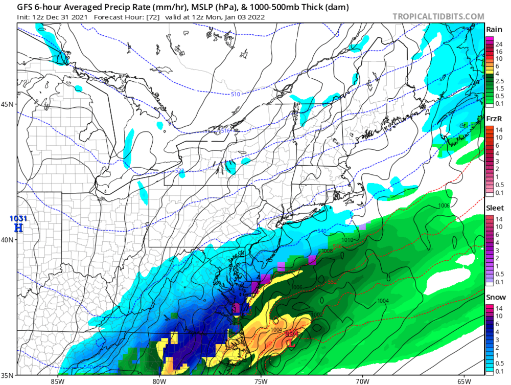
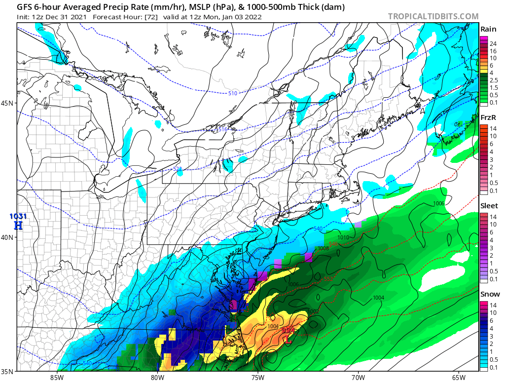
That’s some deep dark blue! 10”/hour stuff, lol…Looks like a quick hitter for them but weenies down there must be pumped right now.
-
12 minutes ago, lakeeffectkid383 said:
Thank god we have the Bills because that’s about the only good thing to look forward to with the weather pattern so darn crappy. We going to be a top 5 low snowfall winter at BUF?
I flipped through the models quickly this morning and actually thought things were looking up...Big ridge forming above then on top of Alaska, shifting the trof east towards us, opening the door for some serious cold towards end of next week with the obvious lake effect implications. Thought there would be some positive vibes in here. I'm either really bad at model interpretation (likely) or the 79th consecutive morning of temps near 40 with drizzle/low clouds has succeeded in removing all winter hope...
-
3
-
2
-
-
11 minutes ago, BuffaloWeather said:
Had tickets to Hamilton musical today, they canceled 2 hours before the show due to lead actor getting covid. Really hope I get to see before they leave.
Oh no! We have tickets for Sat night. Hope it works out for you (and us).
-
1
-
-
5 minutes ago, TugHillMatt said:
It's obviously just one run, but after whatever falls tonight, BUF, ROC, and SYR all get like ONE inch of snow through the end of next week. Just ugly.
Looks like we’re still on track for a run at 60 by end of next week though! But not to worry, a cold front will plow through thereafter and plunge our temps down to the upper 30’s.
-
3
-


Widespread Snow Potential January 16th to January 18th
in Upstate New York/Pennsylvania
Posted
Seeing as how Buffalo’s greatest Miller A snowstorm was the fabled Appalachian Spine Runner back on January 23, 1827 when 8.2” of snow fell I sadly have to pass on the model runs showing anything over 12” in WNY.